Boosmansbos Wilderness Area

Last updated
Boosmansbos Wilderness Area

Grootvadersbosch Nature Reserve PICT3779 Kopie.jpg

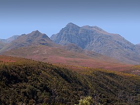
Boosmansbos Wilderness Area, with Grootberg in the background
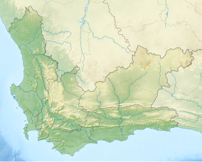
South Africa Western Cape relief location map.svg
Red pog.svg
Map of Western Cape
Location Western Cape Province, South Africa
Nearest city Heidelberg
Coordinates 33°55′S20°52′E / 33.917°S 20.867°E / -33.917; 20.867 Coordinates: 33°55′S20°52′E / 33.917°S 20.867°E / -33.917; 20.867
Area 142 km2 (55 sq mi)
UNESCO World Heritage Site
Criteria Natural: (ix), (x) Blue pencil.svg
Reference 1007-006
Inscription 2004 (28th Session)
Extensions 2015

The Boosmansbos Wilderness Area of 142 km2 (55 sq mi) is situated 20 km (12 mi) north of Heidelberg in the eastern Langeberg mountain chain of the Western Cape Province, South Africa. Boosmansbos, i.e. 'angry man's forest', is named after a resident hermit of the early 19th century who had been known to scare youngsters who visited his apiaries.

Heidelberg, Western Cape Place in Western Cape, South Africa

Heidelberg is a town in the Western Cape, South Africa. It is located near South Africa's south coast, on the N2 highway, 274 km east of Cape Town. Heidelberg is just east of the Overberg region, and some consider it the beginning of the Garden Route. Heidelberg is part of the Hessequa Local Municipality. Fourie House on Fourie Street is the oldest house in Heidelberg.

Langeberg

The Langeberg Range is a mountain range in the Western Cape province of South Africa. Its highest peak is Keeromsberg at 2075m and 15 km NE of the town of Worcester. Some of the highest peaks of the range are located just to the north of Swellendam, in a subrange known as the Clock Peaks whose highest point is 1710 m high Misty Point. Local lore states one can tell the time by means of the shadows cast by the seven summits of the Clock Peaks.

South Africa Republic in the southernmost part of Africa

South Africa, officially the Republic of South Africa (RSA), is the southernmost country in Africa. It is bounded to the south by 2,798 kilometres (1,739 mi) of coastline of Southern Africa stretching along the South Atlantic and Indian Oceans; to the north by the neighbouring countries of Namibia, Botswana, and Zimbabwe; and to the east and northeast by Mozambique and Eswatini (Swaziland); and it surrounds the enclaved country of Lesotho. South Africa is the largest country in Southern Africa and the 25th-largest country in the world by land area and, with over 57 million people, is the world's 24th-most populous nation. It is the southernmost country on the mainland of the Old World or the Eastern Hemisphere. About 80 percent of South Africans are of Sub-Saharan African ancestry, divided among a variety of ethnic groups speaking different African languages, nine of which have official status. The remaining population consists of Africa's largest communities of European (White), Asian (Indian), and multiracial (Coloured) ancestry.

The elevation reaches 1,637 m (5,371 ft) at Grootberg peak, located at the center of the wilderness area. The tributaries of the Duiwenhoks River, which drain its southern slopes, tumble along precipitous gorges to 200 m (660 ft) above sea level on the southern perimeter. In the southwest the wilderness area encloses the Grootvadersbosch Nature Reserve of 250 ha (620 acres), the most western natural forest in South Africa.

Duiwenhoks River, located in Western Cape, South Africa, drains the Langeberg Mountains and flows south to the coast, entering the sea west of Mossel Bay in the Southern Cape. The river is approximately 83 km long with a catchment area of 1 340 km2. The Noukrans River is a tributary.

Sea level Average level for the surface of the ocean at any given geographical position on the planetary surface

Mean sea level (MSL) is an average level of the surface of one or more of Earth's oceans from which heights such as elevation may be measured. MSL is a type of vertical datum – a standardised geodetic datum – that is used, for example, as a chart datum in cartography and marine navigation, or, in aviation, as the standard sea level at which atmospheric pressure is measured to calibrate altitude and, consequently, aircraft flight levels. A common and relatively straightforward mean sea-level standard is the midpoint between a mean low and mean high tide at a particular location.

The wilderness area conserves mountain fynbos and valley forest. Among the special fynbos plants conserved are Erica and everlasting species as well as the rare Langeberg rambling aloe. Important forest tree species occurring in the valleys are sickle-leaved yellowwood, stinkwood and red alder.

Fynbos shrubland and heathland vegetation of southwestern South Africa

Fynbos is a small belt of natural shrubland or heathland vegetation located in the Western Cape and Eastern Cape provinces of South Africa. This area is predominantly winter rainfall coastal and mountainous areas with a Mediterranean climate. The fynbos ecoregion is within the Mediterranean forests, woodlands, and scrub biome. In fields related to biogeography, fynbos is known for its exceptional degree of biodiversity and endemism, consisting about 80% species of the Cape floral kingdom where nearly 6,000 of them are endemic. This land has faced severe threats and still does, but due to the many economic uses conservation efforts are being made to help restore it.

Ericaceae family of plants

The Ericaceae are a family of flowering plants, commonly known as the heath or heather family, found most commonly in acid and infertile growing conditions. The family is large, with c. 4250 known species spread across 124 genera, making it the 14th most species-rich family of flowering plants. The many well-known and economically important members of the Ericaceae include the cranberry, blueberry, huckleberry, rhododendron, and various common heaths and heathers.

<i>Aloiampelos decumbens</i> species of plant

Aloiampelos decumbens, formerly Aloe decumbens, the Langeberg rambling-aloe, is a sprawling, succulent plant that is endemic to the fynbos vegetation of the Langeberg Mountains near Swellendam and Riversdale in the Western Cape, South Africa.

The area receives rain in any month of the year, although mid summer and mid winter are the driest, when hot bergwind conditions may occur. 64 km (40 mi) of footpaths allow access to the wilderness, among which a circular 27 km (17 mi) section which can be completed in two days.

See also

The protected areas of South Africa include national parks and marine protected areas managed by the national government, public nature reserves managed by provincial and local governments, and private nature reserves managed by private landowners. Most protected areas are intended for the conservation of flora and fauna. National parks are maintained by South African National Parks (SANParks). A number of national parks have been incorporated in transfrontier conservation areas.

South African National Parks The body responsible for managing South Africas national parks.

South African National Parks (SANParks) is the body responsible for managing South Africa's national parks. SANParks was formed in 1926, and currently manages 21 parks consisting of over 4,000,000 hectares (40,000 km2), over 3% of the total area of South Africa.

Related Research Articles

Table Mountain A flat-topped mountain overlooking the city of Cape Town

Table Mountain is a flat-topped mountain forming a prominent landmark overlooking the city of Cape Town in South Africa. It is a significant tourist attraction, with many visitors using the cableway or hiking to the top. The mountain forms part of the Table Mountain National Park. Table Mountain is home to a large array of fauna and flora, most of which is endemic.

Cape Peninsula Rocky peninsula in the Western Cape, South Africa

The Cape Peninsula is a generally rocky peninsula that juts out into the Atlantic Ocean at the south-western extremity of the African continent. At the southern end of the peninsula are Cape Point and the Cape of Good Hope. On the northern end is Table Mountain, overlooking Cape Town, South Africa. The peninsula is 52 km long from Mouille point in the north to Cape Point in the south.

Table Mountain National Park A national park on tha Cape Peninsula in the vicinity of Cape Town, South Africa

Table Mountain National Park, previously known as the Cape Peninsula National Park, is a national park in Cape Town, South Africa, proclaimed on 29 May 1998, for the purpose of protecting the natural environment of the Table Mountain Chain, and in particular the rare fynbos vegetation. The park is managed by South African National Parks. The property is included as part of the UNESCO Cape Floral Region World Heritage Site.

Cape Floristic Region Smallest of the six recognised floral kingdoms of the world

The Cape Floristic Region is a floristic region located near the southern tip of South Africa. It is the only floristic region of the Cape Floristic Kingdom, and includes only one floristic province, known as the Cape Floristic Province.

Du Toits Peak Mountain range in South Africa

The Du Toitskloof Mountains (Dutoitsberge) are a range in the Cape Fold Belt in the Western Cape Province of South Africa. The highest point is Du Toits Peak (Dutoitspiek) which is the highest seaward facing peak in the Cape Fold Belt ranges, i.e. the highest peak in the Western Cape within direct sight of the ocean.

Kogelberg mountain range in the Western Cape, South Africa

The Kogelberg is a range of mountains along the False Bay coast in the Western Cape of South Africa. They form part of the Cape Fold Belt, starting south of the Elgin valley and forming a steep coastal range as far as Kleinmond.

Outeniqua Mountains mountain range

The Outeniqua Mountains, named after the Outeniqua Khoikhoi who lived there, is a mountain range that runs a parallel to the southern coast of South Africa, and forms a continuous range with the Langeberg to the west and the Tsitsikamma Mountains to the east. It was known as "Serra de Estrella" to the Portuguese. The mountains are part of the Garden Route of South Africa.

Garden Route National Park Coastal national park in the Garden Route region of the Western Cape and Eastern Cape provinces in South Africa

The Garden Route National Park is a national park in the Garden Route region of the Western Cape and Eastern Cape provinces in South Africa. It is a coastal reserve well known for its indigenous forests, dramatic coastline, and the Otter Trail. It was established on 6 March 2009 by amalgamating the existing Tsitsikamma and Wilderness National Parks, the Knysna National Lake Area, and various other areas of state-owned land.

<i>Aloiampelos gracilis</i> species of plant

Aloiampelos gracilis, formerly Aloe gracilis, the rocket aloe, is a succulent plant, endemic to the area around the city of Port Elizabeth, South Africa. Its natural range lies just to the west of the related Aloiampelos ciliaris, and it occurs in bushy fynbos and thickets, and clustered on rocky outcrops at all altitudes.

Peninsula Granite Fynbos

Peninsula Granite Fynbos is an endangered Fynbos vegetation type which is endemic to the city of Cape Town and occurs nowhere else. It is a unique type of tall, dense and diverse scrubland, scattered with trees. It can be found all along the belt of granite that encircles Table Mountain.

Peninsula Sandstone Fynbos

Peninsula Sandstone Fynbos is a unique and endangered vegetation type that is endemic to the Cape Peninsula in Cape Town. This type of Mountain Fynbos occurs on very poor, acidic soils but is incredibly rich in biodiversity with an enormous number of plant species – many of which occur nowhere else. Due to its poor soils and steep, inaccessible location, it has not been developed for farming or houses, and consequently it is relatively well conserved.

Cape Winelands Shale Fynbos

Cape Winelands Shale Fynbos is a vegetation type that naturally occurs in the Cape Winelands of the Western Cape, South Africa.

Kogelberg Nature Reserve Biosphere reserve in South Africa | designated in 1998

Kogelberg Nature Reserve is a nature reserve of 3,000 ha comprising the Kogelberg Mountain Range, to the east of Cape Town, South Africa.

<i>Carpobrotus mellei</i> species of plant

Carpobrotus mellei is a succulent perennial of the family Aizoaceae, native to the inland mountain ranges of the Western Cape, South Africa.

The Gouritz Cluster Biosphere Reserve is located in the southern part of South Africa. It is divided into four connected sectors ranging from sea level to 2,240 metres. The area is the only place in the world where three recognized biodiversity hotspots converge. The site is characterized by high endemism of plant species and threatened invertebrates including seven endemic species of the enigmatic beetle genus Colophon and 14 butterfly species. It provides a migratory route for large mammals such as the leopard and serves as a nursery for marine species.

The Kammanassie Mountains are a mountain range in the Western Cape, South Africa. The highest peak is Mannetjiesberg at 1,955 metres above sea level and the mountain range is one of the prominent east-west trending ranges composing the southern branch of the Cape Fold Belt.

References