The northern gannet is a seabird, the largest species of the gannet family, Sulidae. It is native to the coasts of the Atlantic Ocean, breeding in Western Europe and Northeastern North America. It is the largest seabird in the northern Atlantic. The sexes are similar in appearance. The adult northern gannet has a mainly white streamlined body with a long neck, and long and slender wings. It is 87–100 cm long with a 170–180 cm (67–71 in) wingspan. The head and nape have a buff tinge that is more prominent in breeding season, and the wings are edged with dark brown-black feathers. The long, pointed bill is blue-grey, contrasting with black, bare skin around the mouth and eyes. Juveniles are mostly grey-brown, becoming increasingly white in the five years it takes them to reach maturity.

The African penguin, also known as Cape penguin or South African penguin, is a species of penguin confined to southern African waters. Like all penguins, it is flightless, with a streamlined body and wings stiffened and flattened into flippers for a marine habitat. Adults weigh an average of 2.2–3.5 kg (4.9–7.7 lb) and are 60–70 cm (24–28 in) tall. The species has distinctive pink patches of skin above the eyes and a black facial mask. The body's upper parts are black and sharply delineated from the white underparts, which are spotted and marked with a black band.

The Australasian gannet, also known as the Australian gannet or tākapu, is a large seabird of the booby and gannet family, Sulidae. Adults are mostly white, with black flight feathers at the wingtips and lining the trailing edge of the wing. The central tail feathers are also black. The head is tinged buff-yellow, with a pearly grey bill edged in dark grey or black, and blue-rimmed eyes. Young birds have mottled plumage in their first year, dark above and light below. The head is an intermediate mottled grey, with a dark bill. The birds gradually acquire more white in subsequent seasons until they reach maturity after five years.

Farewell Spit is a narrow sand spit at the northern end of the Golden Bay, in the South Island of New Zealand. The spit includes around 25 kilometres (16 mi) of stable land and another 5 kilometres (3.1 mi) of mobile sand spit running eastwards from Cape Farewell, the northern-most point of the South Island. Farewell Spit is the longest sand spit in New Zealand, and is a legally protected Nature Reserve. The area is designated as a Ramsar wetland site and an East Asian–Australasian Flyway Shorebird Network site. Farewell Spit is administered by the New Zealand Department of Conservation as a seabird and wildlife reserve. Apart from a small area at the base of the spit, it is closed to the public except through organised tours.

Cape Kidnappers, known in Māori as Te Kauwae-a-Māui and officially gazetted as Cape Kidnappers / Te Kauwae-a-Māui, is a headland at the southeastern extremity of Hawke's Bay on the east coast of New Zealand's North Island and sits at the end of an 8 kilometres (5.0 mi) peninsula which protrudes into the Pacific Ocean. It is 20 kilometres (12 mi) south-east of the city of Napier. Access to the cape by road stops at Clifton, which is the departure point for many tourists visiting the gannet colony. The Cape Kidnappers Golf Course lies between the headland and the nearby coastal community of Te Awanga.

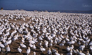
The Cape gannet is a large seabird of the gannet family, Sulidae.

Addo Elephant National Park is a diverse wildlife conservation park situated close to Gqeberha in South Africa and is one of the country's 20 national parks. It currently ranks third in size after Kruger National Park and the Kgalagadi Transfrontier Park.

Algoa Bay is a maritime bay in the Eastern Cape, South Africa. It is located in the east coast, 683 kilometres (424 mi) east of the Cape of Good Hope.

Black Pyramid Rock is an island nature reserve, with an area of 40 ha, in Bass Strait, south-eastern Australia. It is part of Tasmania’s Hunter Island Group which lies between north-west Tasmania and King Island. It is part of the Albatross Island and Black Pyramid Rock Important Bird Area. It is notable for its Australasian gannet colony which, at over 12,000 pairs, is the largest in Tasmania and supports about 20% of the world population of the species.
The Little Goose Island, part of the Badger Group within the Furneaux Group, is a 3.6-hectare (8.9-acre) unpopulated flat, round granite island, located in Bass Strait, lying west of the Flinders and Cape Barren islands, Tasmania, south of Victoria, in south-eastern Australia. The island is contained within a nature reserve and is part of the Chalky, Big Green and Badger Island Groups Important Bird Area.

The Cat Island, part of the Babel Group within the Furneaux Group, is a 39-hectare (96-acre) unpopulated granite island, located in Bass Strait, lying off the east coast of Flinders Island, Tasmania, south of Victoria, in south-eastern Australia.
Mercury Island is a small rocky island off The Diamond Coast, Namibia. Despite its small size it is recognised by BirdLife International and other global conservation groups as an Important Bird Area (IBA) for its significant coastal seabird breeding.

The West Coast National Park lies 88 km (55 mi) north of Cape Town in the Western Cape province of South Africa. The park is found inside of the Cape West Coast Biosphere Reserve, part of the UNESCO Man and the Biosphere Programme. It is bordered by the Atlantic Ocean on the west and the R27 coastal road, and runs from the town of Yzerfontein in the south, up to the Langebaan Lagoon. The park is particularly well known for its bird life and for the spring flowers which occur in the months from August to September, especially in the Postberg flower reserve section of the park. The park, with the islands in Saldanha Bay, has been identified by BirdLife International as an Important Bird Area. The park was proclaimed in 1985, and is 36,259.8 hectares (140.000 sq mi) in size.
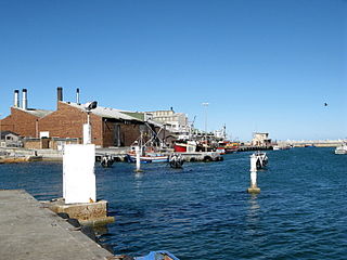
Lambert's Bay is a small fishing town in the Western Cape province of South Africa situated 280 kilometres (170 mi) north of Cape Town. It is part of the Cederberg Municipality.

The Rookery Islands are a group of rocks and small islands in western Holme Bay, north of the David and Masson Ranges, on the Mawson Coast of Mac.Robertson Land in East Antarctica. The largest in the group are Giganteus Island in the north-west, 600 m long by 400 m wide, and Rookery Island in the south, 1 km long and 250 m wide. The islands are rocky and of low relief, rising to heights of 60 m on Rookery Island, 25 m on Giganteus Island, and ranging from 10 – 30 m on the smaller islands. The nearest permanent research station is Australia's Mawson, some 15 km to the east in Holme Bay.

Ardley Island is an island 1.9 kilometres (1 nmi) long, lying in Maxwell Bay close off the south-west end of King George Island, in the South Shetland Islands of Antarctica. It was charted as a peninsula in 1935 by Discovery Investigations personnel of the Discovery II and named for Lieutenant R.A.B. Ardley, Royal Naval Reserve, an officer on the ship in 1929–31 and 1931–33. Aerial photography has since shown that the feature is an island with Braillard Point being the headland forming the northeast end of Ardley Island. It has been designated an Antarctic Specially Protected Area because of the importance of its seabird colonies.
Cape Hansen is a cape which separates Marshall Bay and Iceberg Bay on the south coast of Coronation Island, in the South Orkney Islands, Antarctica. The name appears on a chart based upon a running survey of the islands in 1912–13 by Petter Sørlle, a Norwegian whaling captain.
The Lawrence Rocks are a group of two rocky islets, 6.8 ha and 1.5 ha in area, with an associated reef, 2.4 km south-east of Point Danger in western Victoria, Australia, and about 6 km south-east of the city of Portland. Geologically, the group is formed from the remnants of an extinct volcano, with the islets composed of basalt and tuff.
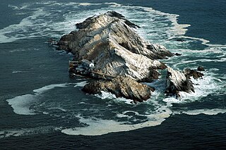
Malgas Island is a small, 8.3 hectares, uninhabited island lying in the northern part of the entrance to Saldanha Bay, in the Western Cape province of South Africa. It lies about 800 metres (2,600 ft) from the mainland in the Benguela upwelling system. It is circular in shape and flat, with the highest point about 9 metres (30 ft) above sea level. It is known for its large breeding colony of Cape gannets.

Ichaboe Island is a small rocky island off Namibia's Diamond Coast. It is recognised by BirdLife International as an Important Bird Area (IBAs) for its seabird breeding colonies.