South Africa occupies the southern tip of Africa, its coastline stretching more than 2,850 kilometres from the desert border with Namibia on the Atlantic (western) coast southwards around the tip of Africa and then northeast to the border with Mozambique on the Indian Ocean. The low-lying coastal zone is narrow for much of that distance, soon giving way to a mountainous escarpment that separates the coast from the high inland plateau. In some places, notably the province of KwaZulu-Natal in the east, a greater distance separates the coast from the escarpment. Although much of the country is classified as semi-arid, it has considerable variation in climate as well as topography. The total land area is 1,220,813 km2 (471,359 sq mi). It has the 23rd largest Exclusive Economic Zone of 1,535,538 km2 (592,875 sq mi).

The Karoo is a semi-desert natural region of South Africa. No exact definition of what constitutes the Karoo is available, so its extent is also not precisely defined. The Karoo is partly defined by its topography, geology and climate, and above all, its low rainfall, arid air, cloudless skies, and extremes of heat and cold. The Karoo also hosted a well-preserved ecosystem hundreds of million years ago which is now represented by many fossils.

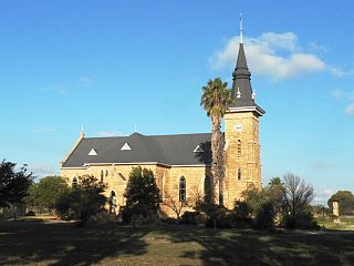
Kannaland Municipality is a local municipality located within the Garden Route District Municipality in the Western Cape province of South Africa. The municipal area is situated in the western part of the Little Karoo and includes the towns of Ladismith, Calitzdorp and Zoar. As of 2011 it has a population of 24,767. Its municipality code is WC041.

The Langeberg Range is a mountain range in the Western Cape province of South Africa. Its highest peak is Keeromsberg at 2,075 m that lies 15 km northeast of the town of Worcester. Some of the highest peaks of the range are located just to the north of Swellendam, in a subrange known as the Clock Peaks whose highest point is the 1,710 m high Misty Point. Local lore states one can tell the time by means of the shadows cast by the seven summits of the Clock Peaks.

Tankwa Karoo National Park is a national park in South Africa. The park lies about 70 km due west of Sutherland near the border of the Northern Cape and Western Cape, in one of the most arid regions of South Africa, with areas receiving less than 100 mm of average annual precipitation, moisture-bearing clouds from the Atlantic Ocean being largely stopped by the Cederberg mountains. Other low areas receive little more, as the Roodewerf station with 180 mm of mean annual rainfall. In the hottest areas of the park, the mean maximum temperature in January is 38.9 °C, and in July the mean minimum temperature ranges from about 5 to 7 °C. Before this Park's proclamation, the only protected area of Succulent Karoo was the 2 square kilometre patch of the Gamkaberg Nature Reserve. Succulent Karoo has, together with the Cape Floral Kingdom, been declared a Biodiversity Hotspot by Conservation International.

The Karoo National Park, founded in 1979, is a wildlife reserve in the Great Karoo area of the Western Cape, South Africa near Beaufort West. This semi-desert area covers an area of 750 square kilometres (290 sq mi). The Nuweveld portion of the Great Escarpment runs through the Park. It is therefore partly in the Lower Karoo, at about 850 m above sea level, and partly in the Upper Karoo at over 1300 m altitude.

The Richtersveld is a desert landscape characterised by rugged kloofs and high mountains, situated in the north-western corner of South Africa’s Northern Cape province. It is full of changing scenery from flat, sandy, coastal plains, to craggy sharp mountains of volcanic rock and the lushness of the Orange River, which forms the border with neighboring Namibia. The area ranges in altitude from sea level, to 1,377 m (4,518 ft) at Cornellberg. Located in the north-eastern side of the Northern Cape province in South Africa, the Richtersveld is regarded as the only arid biodiversity hotspot on earth and the majority of the area is inscribed on UNESCO's World Heritage List due to its cultural values.

The Succulent Karoo is a ecoregion defined by the World Wide Fund for Nature to include regions of desert in South Africa and Namibia, and a biodiversity hotspot. The geographic area chosen by the WWF for what they call 'Succulent Karoo' does not correspond to the actual Karoo.

The wildlife of South Africa consists of the flora and fauna of this country in southern Africa. The country has a range of different habitat types and an ecologically rich and diverse wildlife, vascular plants being particularly abundant, many of them endemic to the country. There are few forested areas, much savanna grassland, semi-arid Karoo vegetation and the fynbos of the Cape Floristic Region. Famed for its national parks and big game, 297 species of mammal have been recorded in South Africa, as well as 858 species of bird and over 20,000 species of vascular plants.
Namaqua National Park is a South African national park situated approximately 495 km north of Cape Town and 22 km northwest of Kamieskroon. It has an area of more than 1300 km2. The park is part of Namaqualand, an area covering 55,000 km2 located within the semi-desert Succulent Karoo biome. This biome is a biodiversity hotspot with the largest concentration of succulent plants in the world. The park also has an arid environment with succulent plants. The park was created to protect its flowers. During the spring, wildflowers bloom there in a spectacular fashion. The park's main tourist attraction is this abundant spring bloom of brightly coloured wildflowers.

The R62 is a provincial route in South Africa that connects Ashton with Humansdorp. The R62 runs through the Little Karoo and the Langkloof, passing through Montagu, Ladismith, Calitzdorp, Oudtshoorn, and Joubertina.

Touws River is a small railway town of 6,800 people in the Western Cape province of South Africa. It is located on the river of the same name, about 160 kilometres (100 mi) north-east of Cape Town. The Touwsrivier CPV Solar Project is located just outside of the town and supplies 50 MW to the national electrical grid.

Wolfgat Nature Reserve is a coastal nature reserve in Mitchells Plain on False Bay in the Western Cape, South Africa.
Nieuwoudtville is a town in Namakwa District Municipality in the Northern Cape province of South Africa. The town lies on the Bokkeveld Escarpment, and was established in 1897. The Nieuwoudtville Falls on the Doring River are located a few kilometres north of the town.

Gasteria brachyphylla is succulent plant native to the Western Cape, South Africa.
The Gouritz Cluster Biosphere Reserve is located in the southern part of South Africa. It is divided into four connected sectors ranging from sea level to 2,240 metres. The area is the only place in the world where three recognized biodiversity hotspots converge. The site is characterized by high endemism of plant species and threatened invertebrates including seven endemic species of the enigmatic beetle genus Colophon and 14 butterfly species. It provides a migratory route for large mammals such as the leopard and serves as a nursery for marine species.
The Cape Winelands Biosphere Reserve is located in the Western Cape Province of South Africa approximately 40 km east of Cape Town. The Biosphere Reserve extends from the Kogelberg Biosphere Reserve in the south, northwards along the Cape Fold Belt Mountain Chain and the adjoining valleys constituting the Cape Winelands. The Biosphere Reserve incorporates key portions of the registered Cape Floral Region Protected Areas World Heritage Site. The Reserve was designated in 2007.

The Gamkaberg Nature Reserve is situated in the Little Karoo region of the Western Cape province, South Africa.
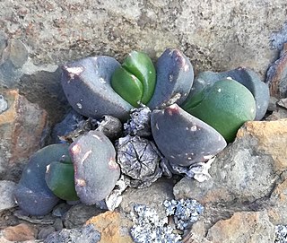
Glottiphyllum suave is a species of succulent plant, of the family Aizoaceae. It is indigenous to arid areas of the western Little Karoo, in the Western Cape, South Africa.