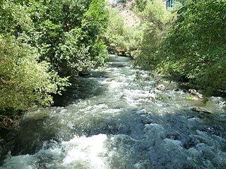
Kasagh is a river in the west-central region of modern Armenia which flows north to south. It originates near Mount Aragats in Aragatsotn province, flows south into Armavir province and into the Metsamor River, which itself is a tributary of the Aras River.

Mirbach Palace is a Rococo-style palace in the Old Town, Bratislava, built from 1768 to 1770 for Bratislava brewer Michal Spech. The palace is named after its last owner, Count Emil Mirbach. Count Emil Mirbach was shot in 1945 by the invading Russians and the palace was expropriated along with the contained Mirbach's art collections. The palace was completely renovated in 1975 and made a seat of the Bratislava City Gallery. It houses Central European baroque painting and sculptures exhibition and temporary exhibitions.

Kukuryki is a village in the administrative district of Gmina Terespol, within Biała Podlaska County, Lublin Voivodeship, in eastern Poland, close to the border with Belarus. It lies approximately 3 kilometres (2 mi) north of Terespol, 32 km (20 mi) east of Biała Podlaska, and 118 km (73 mi) north-east of the regional capital Lublin.

Żakowiec is a village in the administrative district of Gmina Dąbrowice, within Kutno County, Łódź Voivodeship, in central Poland. It lies approximately 3 kilometres (2 mi) south-east of Dąbrowice, 20 km (12 mi) north-west of Kutno, and 63 km (39 mi) north-west of the regional capital Łódź.

Byszew is a village in the administrative district of Gmina Grabów, within Łęczyca County, Łódź Voivodeship, in central Poland. It lies approximately 17 kilometres (11 mi) north-west of Łęczyca and 50 km (31 mi) north-west of the regional capital Łódź.

Gęsice is a village in the administrative district of Gmina Łagów, within Kielce County, Świętokrzyskie Voivodeship, in south-central Poland. It lies approximately 5 kilometres (3 mi) south-east of Łagów and 38 km (24 mi) south-east of the regional capital Kielce.

Stara Słupia is a village in the administrative district of Gmina Nowa Słupia, within Kielce County, Świętokrzyskie Voivodeship, in south-central Poland. It lies approximately 2 kilometres (1 mi) east of Nowa Słupia and 35 km (22 mi) east of the regional capital Kielce.

Jasieniec-Maziarze is a village in the administrative district of Gmina Iłża, within Radom County, Masovian Voivodeship, in east-central Poland. It lies approximately 8 kilometres (5 mi) south-west of Iłża, 33 km (21 mi) south of Radom, and 124 km (77 mi) south of Warsaw.
Krzekotowice is a village in the administrative district of Gmina Pępowo, within Gostyń County, Greater Poland Voivodeship, in west-central Poland.

Kuźnica Zbąska is a village in the administrative district of Gmina Rakoniewice, within Grodzisk Wielkopolski County, Greater Poland Voivodeship, in west-central Poland. It lies approximately 15 kilometres (9 mi) north-west of Rakoniewice, 18 km (11 mi) west of Grodzisk Wielkopolski, and 59 km (37 mi) west of the regional capital Poznań.
Osiecza Druga is a village in the administrative district of Gmina Rzgów, within Konin County, Greater Poland Voivodeship, in west-central Poland.
Łęgi is a village in the administrative district of Gmina Baborów, within Głubczyce County, Opole Voivodeship, in south-western Poland.

Róg Osada is a settlement in the administrative district of Gmina Studzienice, within Bytów County, Pomeranian Voivodeship, in northern Poland. It lies approximately 8 kilometres (5 mi) east of Studzienice, 13 km (8 mi) east of Bytów, and 69 km (43 mi) south-west of the regional capital Gdańsk.

Żeńsko is a village in the administrative district of Gmina Krzęcin, within Choszczno County, West Pomeranian Voivodeship, in north-western Poland. It lies approximately 4 kilometres (2 mi) north-west of Krzęcin, 8 km (5 mi) south-east of Choszczno, and 68 km (42 mi) south-east of the regional capital Szczecin.

Gościmierz is a village in the administrative district of Gmina Karnice, within Gryfice County, West Pomeranian Voivodeship, in north-western Poland. It lies approximately 6 kilometres (4 mi) south-east of Karnice, 11 km (7 mi) north-west of Gryfice, and 73 km (45 mi) north-east of the regional capital Szczecin.
Orzeń is a settlement in the administrative district of Gmina Człopa, within Wałcz County, West Pomeranian Voivodeship, in north-western Poland.

Hayter is a hamlet in central Alberta, Canada within the Municipal District of Provost No. 52. It is located 0.6 kilometres (0.37 mi) south of Highway 13, approximately 103 kilometres (64 mi) south of Lloydminster. It was founded in 1909 and named after the president of CP Hotels.

Commune II (Niamey), also known as Niamey II, is an urban commune in Niger. It is a commune of the capital city of Niamey.
Santa Mônica is a municipality in the state of Paraná in the Southern Region of Brazil.
Platzerberg is a mountain of Saxony, southeastern Germany.


