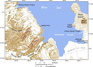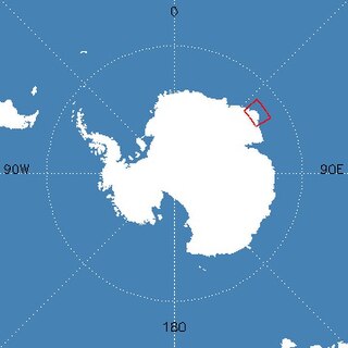
The Ross Sea is a deep bay of the Southern Ocean in Antarctica, between Victoria Land and Marie Byrd Land and within the Ross Embayment, and is the southernmost sea on Earth. It derives its name from the British explorer James Clark Ross who visited this area in 1841. To the west of the sea lies Ross Island and Victoria Land, to the east Roosevelt Island and Edward VII Peninsula in Marie Byrd Land, while the southernmost part is covered by the Ross Ice Shelf, and is about 200 miles (320 km) from the South Pole. Its boundaries and area have been defined by the New Zealand National Institute of Water and Atmospheric Research as having an area of 637,000 square kilometres (246,000 sq mi).

The McMurdo Dry Valleys are a row of largely snow-free valleys in Antarctica, located within Victoria Land west of McMurdo Sound. The Dry Valleys experience extremely low humidity and surrounding mountains prevent the flow of ice from nearby glaciers. The rocks here are granites and gneisses, and glacial tills dot this bedrock landscape, with loose gravel covering the ground. It is one of the driest places on Earth and is sometimes claimed to have not seen rain in nearly two million years, though this is highly unlikely and several anecdotal accounts of rainfall within the Dry Valleys exist.
Borchgrevink Glacier is a large glacier in the Victory Mountains, Victoria Land, Antarctica. It drains south between Malta Plateau and Daniell Peninsula, and thence projects into Glacier Strait, Ross Sea, as a floating glacier tongue.
The Napier Mountains are a group of close set peaks, the highest being Mount Elkins, at about 2,300 meters above sea level. This mountain range is located in Enderby Land, in the claimed Australian Antarctic Territory, East Antarctica.

The Fosdick Mountains are an east–west trending mountain range with marked serrate outlines, standing along the south side of Balchen Glacier at the head of Block Bay, in the Ford Ranges of Marie Byrd Land, Antarctica. They were discovered by the Byrd Antarctic Expedition in 1929, and named by Richard E. Byrd for Raymond B. Fosdick, who became president of the Rockefeller Foundation.

The geology of Australia includes virtually all known rock types, spanning a geological time period of over 3.8 billion years, including some of the oldest rocks on earth. Australia is a continent situated on the Indo-Australian Plate.

The geology of Antarctica covers the geological development of the continent through the Archean, Proterozoic and Phanerozoic eons.

Zykov Glacier is a valley glacier in northern Victoria Land, Antarctica, east of Saddle Peak and Mount Kostka in the Anare Mountains. It is about 25 miles (40 km) long, and flows northwest, reaching the Pennell Coast between Cape Williams and Cooper Bluffs. Photographed by the Soviet Antarctic Expedition from the survey ship Ob in 1958, it was named by them for student navigator Ye. Zykov, who died in Antarctica, February 3, 1957.

Cape Adare is a prominent cape of black basalt forming the northern tip of the Adare Peninsula and the north-easternmost extremity of Victoria Land, East Antarctica.
In geology ultrahigh-temperature metamorphism (UHT) is extreme crustal metamorphism with metamorphic temperatures exceeding 900 °C. Granulite-facies rocks metamorphosed at very high temperatures were identified in the early 1980s, although it took another decade for the geoscience community to recognize UHT metamorphism as a common regional phenomenon. Petrological evidence based on characteristic mineral assemblages backed by experimental and thermodynamic relations demonstrated that Earth's crust can attain and withstand very high temperatures (900–1000 °C) with or without partial melting.

Mount Elkins, also known as Jökelen is a dark, steep-sided mountain with three major peaks, the highest 2,300 meters (7,500 ft) above sea level, in the Napier Mountains of Enderby Land. Enderby Land is part of East Antarctica and is claimed by Australia as part of the Australian Antarctic Territory. The mountain was named after Terence James Elkins, an ionospheric physicist with the Australian National Antarctic Research Expeditions at Mawson Station in 1960.

Borchgrevink Nunatak is a nunatak 1.5 nautical miles (3 km) long which rises to 650 metres (2,130 ft), standing at the south side of the entrance to Richthofen Pass, on the east coast of Graham Land. It was discovered in 1902 by the Swedish Antarctic Expedition under Otto Nordenskiöld, who named it for C. E. Borchgrevink, leader of the British Antarctic Expedition, 1898–1900, to Victoria Land.

The East Antarctic Shield or Craton is a cratonic rock body that covers 10.2 million square kilometers or roughly 73% of the continent of Antarctica. The shield is almost entirely buried by the East Antarctic Ice Sheet that has an average thickness of 2200 meters but reaches up to 4700 meters in some locations. East Antarctica is separated from West Antarctica by the 100–300 kilometer wide Transantarctic Mountains, which span nearly 3,500 kilometers from the Weddell Sea to the Ross Sea. The East Antarctic Shield is then divided into an extensive central craton that occupies most of the continental interior and various other marginal cratons that are exposed along the coast.

Enderby Land is a region of Northeastern Antarctica which extends into the Southern Indian Ocean. The area is claimed by Australia as part of the Australian Antarctic Territory. The unique and diverse geological features of this region have been associated with the evolution and development of the supercontinent Gondwana. Multiple distinct geological formations are located in this region. The most prominent and important are the
- Napier Complex (Archaean)
- Rayner Complex (late-Proterozoic)
- Lützow-Holm Complex (LHC) (early-Paleozoic)
- Yamato–Belgica Complex (early-Paleozoic)

Laura Crispini is an Italian geologist and an Antarctic researcher. Her areas of expertise are for the Tectonics, Geodynamics and Geological Mapping including the Geology of Antarctica. She has been nominated among 150 International representative of female Antarctic researchers for the SCAR "Celebration of Women in Antarctic Research" wikibomb event. At present she is Professor at the University of Genoa at the Department for Earth Sciences, Envinronment and life (DISTAV).
The Chonide orogeny was a mountain building event in the Triassic, preserved in coastal accretionary complexes in southwestern Chile. The Chonos Metamorphic Complex, Madre de Dios Accretionary Complex and Diego de Almagro Complex all crop out west of the South Patagonian Batholith. Rocks in the Chonos Metamorphic Complex include turbidites as well as meta-chert and mafic schist. Some researchers propose that during the Permian, the supercontinent Gondwana moved rapidly northward leading to the formation of back-arc marginal basins. The closure of the basins then resulted in the orogeny.
The Insel orogeny was a mountain building event in the late Archean, 2.65 billion years ago, in what is now Antarctica. First identified by geologists in Queen Maud Land and the southern Prince Charles Mountains, the orogeny produced rocks that reached amphibolite-grade on the sequence of metamorphic facies, produced large areas of new continental crust and altered the large areas of older rock. In the 1970s and 1980s, Antarctic researchers Grikurov and Elliot debated whether the Insel Orogeny marked the end of craton building in East Antarctica, or whether the process continued into the Proterozoic.
The Late Ruker orogeny, also known as the Nimrod orogeny, was a mountain building event around 1 billion years ago in the Proterozoic. Large portions of West Antarctica were added to the continent during this event. The orogeny was marked by subsidence, sedimentation and underwater volcanic eruptions along the proto-Pacific Ocean margin of proto-Antarctica. This melted some older igneous plutonic rocks and metamorphic rocks and caused some new metamorphism.
The Beardmore orogeny was a mountain building event in the Neoproterozoic affecting what is now Antarctica. The event is preserved in the Trans-Antarctic Mountains, potentially in the Shackleton Range and by argillite-greywacke series in the Horlick Mountains, Queen Maud Land and the Thiel Mountains. Upright folds, asymmetric overturned or recumbent isoclinal folds first identified by Elliott in 1975 was interpreted in 1992 by Edmund Stump as indicative of compressive and convergent tectonic activity.

The geology of the Ellsworth Mountains, Antarctica, is a rock record of continuous deposition that occurred from the Cambrian to the Permian periods, with basic igneous volcanism and uplift occurring during the Middle to Late Cambrian epochs, deformation occurring in the Late Permian period or early Mesozoic era, and glacier formation occurring in the Cretaceous period and Cenozoic era. The Ellsworth Mountains are located within West Antarctica at 79°S, 85°W. In general, it is made up of mostly rugged and angular peaks such as the Vinson Massif, the highest mountain in Antarctica.


