
Roanoke County is a county located in the U.S. state of the Commonwealth of Virginia. As of the 2010 census, the population was 92,376. Its county seat is Salem.

Daleville is a census-designated place (CDP) in Botetourt County, Virginia, United States. The population was 2,557 as of the 2010 census, an increase of over 75% from the 2000 census, when the population was 1,454. It is part of the Roanoke Metropolitan Statistical Area. One of the county's two high schools, Lord Botetourt, is located in Daleville.

Lord Botetourt High School (LBHS) is one of two high schools in Botetourt County, Virginia. It was built in 1958, in suburban Daleville, Virginia, opening the fall of 1959. It currently has 73 faculty members serving over 1,000 students grades 9-12. LB, as it is commonly known, is named for Norborne Berkeley, 4th Baron Botetourt, the governor of Virginia from 1768 to 1770. LB's athletic teams are known as the "Cavaliers," and the school colors are Scarlet, Gray, White.

Norborne Berkeley, 4th Baron Botetourt, was a British courtier, member of parliament, and royal governor of the colony of Virginia from 1768 until his death in 1770.

Baron Botetourt is an abeyant title in the Peerage of England. It was created by writ of summons on 19 June 1305. It became abeyant in 1406, was recalled from abeyance in 1764 for Norborne Berkeley. However, it became abeyant again on his death in 1770. It was recalled a second time in 1803 for the 5th Duke of Beaufort, and became a subsidiary title of the Dukes of Beaufort until the death of the 10th Duke in 1984, when it became, and remains, abeyant.
The Roanoke Valley in southwest Virginia is an area adjacent to and including the Roanoke River between the Blue Ridge Mountains to the east and the Appalachian Plateau to the west. The valley includes much of Roanoke County, as well as the two independent cities of Roanoke and Salem.
Fincastle County, Virginia, was created in 1772 from Botetourt County, the boundaries of which extended all the way to the Mississippi River. Fincastle County was abolished in 1776, and divided into three new counties—Montgomery County, Washington County, and Kentucky County —by action of the Virginia General Assembly.
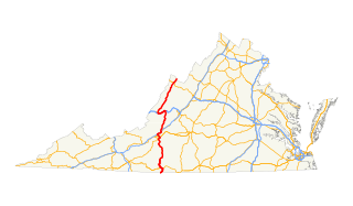
In the U.S. state of Virginia, U.S. Route 220 (US 220) is a major north-south state highway that extends from the North Carolina state line through Roanoke to the West Virginia state line. South of Roanoke, US 220 is a four-lane highway within the proposed Interstate 73 (I-73) corridor. US 220 narrows to two lanes north of Roanoke, connecting to I-64 near Clifton Forge and then paralleling the Appalachian Mountains north-northeasterly in the direction of Cumberland, Maryland.

USS Botetourt (APA-136) was a Haskell-class attack transport built and used by the US Navy in World War II and saw further service during the Korean War. She was a Victory ship design, VC2-S-AP5. She was named after Botetourt County, Virginia, United States.
Eagle Rock is an unincorporated community in Botetourt County, Virginia, United States, located along the James River between Iron Gate and Buchanan.
Arcadia is an unincorporated community in Botetourt County, Virginia, United States. It is located in the north of the county and is one of the northernmost points of the Roanoke Metropolitan Area.
Coyner Springs is an unincorporated community in Botetourt County, Virginia, United States.
Knollwood is an unincorporated community in Botetourt County, Virginia, United States.
Munford is an unincorporated community in Botetourt County, Virginia, United States.
Solitude is an unincorporated community in Botetourt County, Virginia, United States.
Strom is an unincorporated community in Botetourt County, Virginia, United States. Although there are no landmarks or signs, Strom is located in the area of what is now Roaring Run Grocery, a convenience store located across the road from Craig Creek. The entrance to the former site of Willow Bend Campground is located approximately one-half mile to the west. The Deisher family is one of the earliest families to settle in the area. Eagle Rock, located approximately five miles to the east, is the nearest town.

This is a list of the National Register of Historic Places listings in Botetourt County, Virginia.
Terry L. Austin is an American politician from Virginia. A member of the Republican Party, Austin is a member of the Virginia House of Delegates representing the 19th district. He previously served on the Botetourt County Board of Supervisors.

Fincastle Historic District is a national historic district located at Fincastle, Botetourt County, Virginia. It encompasses nine contributing buildings in the central business district of Fincastle. The district resources portray an excellent example of a typical small 19th century town. The buildings include examples of Late Victorian, Greek Revival, and Gothic Revival styles. Notable buildings include the Botetourt County Courthouse and jail, Methodist Church, Presbyterian Church, St. Mark's Episcopal Church (1837), the Peck House, Selander House, Ammen House, and Kyle House (1832).


