
James Madison Jr. was an American statesman, lawyer, diplomat, philosopher, and Founding Father who served as the fourth president of the United States from 1809 to 1817. He is hailed as the "Father of the Constitution" for his pivotal role in drafting and promoting the United States Constitution and the United States Bill of Rights. He also co-wrote The Federalist Papers, co-founded the Democratic-Republican Party, and served as the fifth United States Secretary of State from 1801 to 1809.

The Ohio River is a 981-mile (1,579 km) long river in the midwestern United States that flows southwesterly from western Pennsylvania south of Lake Erie to its mouth on the Mississippi River at the southern tip of Illinois. It is the second largest river by discharge volume in the United States and the largest tributary by volume of the north-south flowing Mississippi River that divides the eastern from western United States. The river flows through or along the border of six states, and its drainage basin includes parts of 15 states. Through its largest tributary, the Tennessee River, the basin includes several states of the southeastern U.S. It is the source of drinking water for three million people.

Thomas Jefferson was an American statesman, diplomat, lawyer, architect, and Founding Father who served as the third president of the United States from 1801 to 1809. Previously, he had served as the second vice president of the United States from 1797 to 1801. The principal author of the Declaration of Independence, Jefferson was a proponent of democracy, republicanism, and individual rights motivating American colonists to break from the Kingdom of Great Britain and form a new nation; he produced formative documents and decisions at both the state and national level.
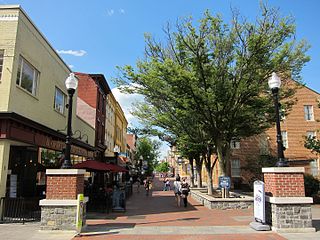
Winchester is an independent city located in the northwestern portion of the Commonwealth of Virginia in the United States. As of the 2010 census, the population was 26,203. As of 2015, its population is an estimated 27,284. It is the county seat of Frederick County, although the two are separate jurisdictions. The Bureau of Economic Analysis combines the city of Winchester with surrounding Frederick County for statistical purposes.
Green wood is unseasoned wood.
The Treaty of Paris, signed in Paris by representatives of King George III of Great Britain and representatives of the United States of America on September 3, 1783, ended the American Revolutionary War. The treaty set the boundaries between the British Empire in North America and the United States, on lines "exceedingly generous" to the latter. Details included fishing rights and restoration of property and prisoners of war.
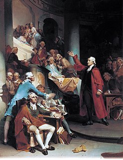
The Virginia House of Burgesses was formed in 1642/43 by the General Assembly. By its creation, the General Assembly then became bicameral.

Slavery in the colonial area which later became the United States (1600–1776) developed from complex factors, and researchers have proposed several theories to explain the development of the institution of slavery and of the slave trade. Slavery strongly correlated with Europe's American colonies' need for labor, especially for the labor-intensive plantation economies of the sugar colonies in the Caribbean, operated by Great Britain, France, Spain, and the Dutch Republic.

In the history of the United States, a slave state was a U.S. state in which the practice of slavery was legal, and a free state was one in which slavery was prohibited or being legally phased out. Historically, in the 17th century, slavery was established in a number of English overseas possessions. In the 18th century, it existed in all the British colonies of North America. In the Thirteen Colonies, the distinction between slave and free states began during the American Revolutionary War (1775–1783). Slavery became a divisive issue and was the primary cause of the American Civil War. The Thirteenth Amendment to the United States Constitution, ratified in 1865, abolished slavery throughout the United States, and the distinction between free and slave states ended.
James Wood was an officer of the U.S. Continental Army during the American Revolution and the 11th Governor of Virginia.
James Wood or Jim Wood may refer to:

The Battle of Fort Necessity took place on July 3, 1754, in what is now Farmington in Fayette County, Pennsylvania. The engagement, along with the May 28 skirmish known as the Battle of Jumonville Glen, was George Washington's first military experience and the only surrender of his military career. The Battle of Fort Necessity began the French and Indian War, which later spiraled into the global conflict known as the Seven Years' War.

Clapboard or clabbard, also called bevel siding, lap siding, and weatherboard, with regional variation in the definition of these terms, is wooden siding of a building in the form of horizontal boards, often overlapping.

False Cape State Park is a 4,321-acre (17.49 km2) state park located on the Currituck Banks Peninsula, a one-mile-wide (1.6 km) barrier spit between the Back Bay of the Currituck Sound and the Atlantic Ocean, within the city of Virginia Beach, adjacent to the state border with North Carolina, and just north of Mackay Island National Wildlife Refuge.

Chilton Woods State Forest is a 397-acre (161 ha) state forest located on the Northern Neck in Lancaster County, Virginia, near the town of Warsaw.

Big Woods State Forest is a 2,188-acre (8.85 km2) state forest in Sussex County, Virginia. It was the first state forest property to be established in southeast Virginia.
Late Extra is a 1935 British crime film directed by Albert Parker and starring James Mason, Virginia Cherrill, and Alastair Sim.

Big Woods Wildlife Management Area is a 4,173-acre (16.89 km2) Wildlife Management Area (WMA) in Sussex County, Virginia. It comprises two tracts of land; the 2,208-acre (8.94 km2) main tract, located immediately adjacent Big Woods State Forest, and the 1,965-acre (7.95 km2) Parker's Branch tract, located nearby.


