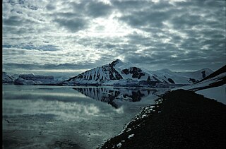
Red Rock Ridge or Morro Roca Roja or Promontorio Roca Roja is a conspicuous reddish-colored ridge or promontory which rises to 690 m and projects from the west coast of Graham Land between Neny Fjord and Rymill Bay. Red Rock Ridge is located at 68°18′S67°08′W and has an elevation of 690 m. Red Rock Ridge was surveyed in 1936 by the British Graham Land Expedition (BGLE) under John Riddoch Rymill, who so named it because of its color. Further surveys in 1948 by the Falkland Islands Dependencies Survey (FIDS) have identified this ridge as the feature first sighted in 1909 and named "Île Pavie" or "Cap Pavie" by the French Antarctic Expedition under Jean-Baptiste Charcot, but the name Red Rock Ridge is now too firmly established to alter. The name Pavie Ridge has been assigned to the prominent rocky ridge at 68°34′S66°59′W.
Mount Wilcox is a mountain with a sharp, rocky, triangular peak surmounting the southeast corner of Square Bay, 13 kilometres (8 mi) east of Camp Point on the west coast of Graham Land, Antarctica. The mountain was apparently first seen and roughly charted in 1909 by the French Antarctic Expedition under Charcot. It was surveyed in 1936 by the British Graham Land Expedition (BGLE) under John Rymill and was photographed from the air in 1940 by the United States Antarctic Service (USAS). The name, proposed by Colonel Lawrence Martin, is for Phineas Wilcox, mate on the Hero, in which Captain Nathaniel Palmer explored the Antarctic mainland south of Deception Island in 1820.
Sharp Glacier is a glacier flowing north to the head of Lallemand Fjord, close east of the Boyle Mountains, in Graham Land. Mapped by Falkland Islands Dependencies Survey (FIDS) from surveys and air photos, 1948-59. Named by United Kingdom Antarctic Place-Names Committee (UK-APC) for Robert P. Sharp, American geologist who has undertaken numerous studies on glaciers and their flow.
Shmidt Point is a point marking the north extremity of Arrowsmith Peninsula, which separates Hanusse Bay and Lallemand Fjord on the west coast of Graham Land. First seen and roughly surveyed in 1909 by the French Antarctic Expedition under Charcot. It was sketched from the air in 1937 by the British Graham Land Expedition (BGLE) under Rymill. Named in 1954 by the United Kingdom Antarctic Place-Names Committee (UK-APC) for Professor Otto Schmidt, director of the Arctic Institute at Leningrad in 1930-32, head of the Chief Administration of the Northern Sea Route in 1932-39, and leader of many Arctic expeditions.
Safety Col is a snow-covered col, 185 m high, between Red Rock Ridge and the Blackwall Mountains, on the west coast of Graham Land. First surveyed in 1936 by the British Graham Land Expedition (BGLE) under Rymill. Resurveyed in 1948-49 by the Falkland Islands Dependencies Survey (FIDS), and so named by them because the col affords a safe sledging route between Neny Fjord and Rymill Bay when there is open water off the west end of Red Rock Ridge.

Prospect Point is a headland at the west extremity of Velingrad Peninsula on Graham Coast in Graham Land, nearly 2 nautical miles (3.7 km) south of Ferin Head and immediately east of the Fish Islands. Roughly charted by the British Graham Land Expedition (BGLE) under Rymill, 1934-37. Photographed by Hunting Aerosurveys Ltd. in 1956-57. The name was suggested in 1957 by E. P. Arrowsmith, Governor of the Falkland Islands.

Bucher Glacier is a small glacier draining the west slopes of Rudozem Heights and flowing to Bourgeois Fjord just north of Bottrill Head on the German Peninsula, Fallières Coast on the west side of Graham Land, Antarctica. It was named by the UK Antarctic Place-Names Committee in 1958 for Edwin Bucher, Swiss glaciologist and author of many publications on snow and avalanches.
Wyatt Island is an island, 5 nautical miles (9 km) long and 2 nautical miles (3.7 km) wide, lying 2 nautical miles (3.7 km) south of Day Island near the center of Laubeuf Fjord, off the west coast of Graham Land. First surveyed in 1936 by the British Graham Land Expedition (BGLE) under Rymill which used the provisional name South Island for this feature. The island was resurveyed in 1948 by the Falkland Islands Dependencies Survey (FIDS) and was renamed by Vice Admiral Sir Arthur G.N. Wyatt, Hydrographer to the Navy, 1945-50.
Nautilus Head is a prominent headland rising to 975 m near the northeast extremity of Pourquoi Pas Island, off the west coast of Graham Land. It was first surveyed in 1936 by the British Graham Land Expedition (BGLE) under Rymill and resurveyed in 1948 by the Falkland Islands Dependencies Survey (FIDS) who named it after the submarine Nautilus in Jules Verne's Twenty Thousand Leagues Under The Sea. Other features on Pourquoi Pas Island are named after characters from that book.
Neny Matterhorn is a sharp, pyramid-shaped peak over 1,125 m, standing in the northwest part of the Blackwall Mountains on the south side of Neny Fjord, Graham Land. First roughly surveyed in 1936-37 by the British Graham Land Expedition (BGLE) under Rymill, and resurveyed in 1948-49 by the Falkland Islands Dependencies Survey (FIDS). The name was apparently first used by members of the Ronne Antarctic Research Expedition (RARE), 1947–48, under Ronne, and the FIDS, and derives from its location near Neny Fjord, and its resemblance to the Matterhorn.
Nicholl Head is a bold west extremity of the ridge separating Dogs Leg Fjord and Square Bay, on the west coast of Graham Land, Antarctica. First surveyed in 1936 by the British Graham Land Expedition (BGLE) under Rymill. Resurveyed in 1948 by the Falkland Islands Dependencies Survey (FIDS) and named for Timothy M. Nicholl, FIDS base leader at the Argentine Islands in 1948 and 1949.

Weir Glacier is a glacier 8 nautical miles (15 km) long, flowing north into the south part of Barilari Bay between Prestoy Point and Byaga Point, on the west coast of Graham Land. First sighted and roughly charted in 1909 by the French Antarctic Expedition under Charcot. It was surveyed in 1935-36 by the British Graham Land Expedition (BGLE) under Rymill and later named for William D. Weir, 1st Viscount Weir of Eastwood, and his son, the Hon. James K. Weir, who contributed toward the cost of the BGLE, 1934-37.

Perutz Glacier is a glacier, 10 nautical miles (18 km) long and 2 nautical miles (3.7 km) wide, which flows west-northwest from Hemimont Plateau into Bourgeois Fjord, close east of Thomson Head, on the west coast of Graham Land, Antarctica. The mouth of the glacier was first surveyed in 1936 by the British Graham Land Expedition (BGLE) under Rymill. The entire glacier was surveyed in 1946-47 and 1948-49 by the Falkland Islands Dependencies Survey (FIDS), and named by them for Max F. Perutz of the Cavendish Laboratory, Cambridge, who has made important studies on the mechanism of glacier flow.
Twig Rock is a small rocky mass, more than 90 m high, between Alamode Island and Hayrick Island in the Terra Firma Islands, off the west coast of Graham Land.
Snowshoe Glacier is a glacier 8 nautical miles (15 km) long flowing west from a col in the southwest flank of Neny Glacier into Neny Fjord, western Graham Land. Roughly surveyed from the ground (1936) and photographed from the air (1937) by British Graham Land Expedition (BGLE). Surveyed by Falkland Islands Dependencies Survey (FIDS) in 1949. The name was suggested by K.S.P. Butler of the FIDS in 1948 because the shape of the glacier with its narrow head and wide mouth resembles a snowshoe.
Thomson Head is a steep, rocky headland rising to 915 m at the east side of Bourgeois Fjord, between Perutz and Bader Glaciers, forming the north extremity of German Peninsula on Fallières Coast on the west side of Graham Land, Antarctica. First surveyed in 1936 by the British Graham Land Expedition (BGLE) under Rymill. Resurveyed in 1948-49 by the Falkland Islands Dependencies Survey (FIDS) and named for William H. Thomson, FIDS air pilot at Stonington Island in 1947.
Remus Glacier is a glacier, 8 nautical miles (15 km) long, which flows from the north slopes of Mount Lupa northwestward along the northeast side of the Blackwall Mountains into Providence Cove, Neny Fjord, on the west coast of Graham Land. The lower reaches of the glacier were first roughly surveyed in 1936 by the British Graham Land Expedition (BGLE) under Rymill. Resurveyed in 1948-49 by the Falkland Islands Dependencies Survey (FIDS), who so named it for its association with Romulus Glacier, whose head lies near the head of this glacier.
Ridge Island is a ridge-shaped island, 6 nautical miles (11 km) long and 1.5 nautical miles (2.8 km) wide lying 3 nautical miles (6 km) east of Pourquoi Pas Island in the center of Bourgeois Fjord, off the west coast of Graham Land. Discovered and named by the British Graham Land Expedition (BGLE), 1934–37, under Rymill.

Clarke Glacier is a 2-mile-wide, 20-mile-long glacier, located on the west coast of Graham Land in Antarctica. It flows west, along the north side of Sickle Mountain and the Baudin Peaksm, to Mikkelsen Bay.
The Spire is an isolated rock pinnacle at the northwest end of the Blackwall Mountains on the south side of Neny Fjord, Graham Land in Antarctica. It was probably first seen by the British Graham Land Expedition (BGLE) sledging parties in 1936-37, though not specifically mapped. The first ascend was on January 17, 1948 by members of Falkland Islands Dependencies Survey (FIDS) and Ronne Antarctic Research Expedition (RARE). The name was first used in 1949 by William Latady, aerial photographer with RARE.


