
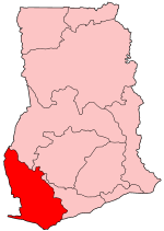
The Western Region is located in south Ghana, spreads from the Ivory Coast in the west to the Central region in the east, includes the capital and large twin city of Sekondi-Takoradi on the coast, coastal Axim, and a hilly inland area including Elubo. It includes Ghana's southernmost location, Cape Three Points, where crude oil was discovered in commercial quantities in June 2007. The region covers an area of 13,842 sq. km, and had a population of 2,060,585 at the 2021 Census.

Sekondi-Takoradi is a city in Ghana comprising the twin cities of Sekondi and Takoradi. It is the capital of Sekondi – Takoradi Metropolitan Assembly and the Western Region of Ghana. Sekondi-Takoradi is the region’s and largest Fante city as well as an industrial and commercial center, with a population of 445,205 people (2012). The chief industries in Sekondi-Takoradi are timber, cocoa processing, plywood, shipbuilding, its harbour and railway repair, and recently, sweet crude oil and crude oil. The fundamental job in Sekondi-Takoradi is fishing. Sekondi-Takoradi lies on the main railway lines to Kumasi and Accra. It is one of the most modern and cleanest cities in Ghana.
Cuyamaca is a region of eastern San Diego County. It lies east of the Capitan Grande Indian Reservation in the western Laguna Mountains, north of Descanso and south of Julian. Named for the 1845 Rancho Cuyamaca Mexican land grant, the region is now dominated by the 26,000-acre (110 km2) Cuyamaca Rancho State Park. Within the park is the prominent Cuyamaca Peak, the second-highest mountain in San Diego County at 6,512 feet (1,984.9 m).

The Brong-Ahafo region was a region in southern Ghana. Brong-Ahafo was bordered to the north by the Black Volta river and to the east by the Lake Volta, and to the south by the Ashanti, Eastern and Western regions. The capital of Brong-Ahafo is Sunyani. Brong-Ahafo was created on 14 April 1959 from the then Western Ashanti and named after the dominant and native inhabitants, Akans, Brong and Ahafo. In 2019, as a result of the 2018 Ghanaian new regions referendum, the region was divided into three, namely Bono, Bono East and Ahafo regions, and ceased to exist.

The Ashanti Region is located in southern part of Ghana and it is the third largest of 16 administrative regions, occupying a total land surface of 24,389 km2 (9,417 sq mi) or 10.2 percent of the total land area of Ghana. In terms of population, however, it is the most populated region with a population of 4,780,380 according to the 2011 census, accounting for 19.4% of Ghana's total population. The Ashanti Region is known for its major gold bar and cocoa production. The largest city and regional capital is Kumasi.

The Northern Region is one of the sixteen regions of Ghana. It is located in the north of the country and was the largest of the sixteen regions, covering an area of 70,384 square kilometres or 31 percent of Ghana's area until December 2018 when the Savannah Region and North East Region were created from it. The Northern Region is divided into 14 districts. The region's capital is Tamale.

Shama Ahanta East Metropolitan District is a former district that was located in Western Region, Ghana. Originally created as a metropolitan district assembly in 1988 when it was known as Sekondi Takoradi Metropolitan Authority Council; which was later renamed as Shama Ahanta East Metropolitan District in 1994. However, on 29 February 2008, it was split off into two new districts: Sekondi Takoradi Metropolitan District and Shama District. The metropolis was located in the southeast part of Western Region and had Sekondi-Takoradi as its capital town.
Scotia was a village in Patton Township, Centre County, Pennsylvania, at 40°47′59″N77°56′46″W. Although the community was called Scotia, the name of the local post office was Benore.
Dongola is an unincorporated community in the Canadian province of Ontario, located within the single-tier municipality of Kawartha Lakes at the intersection of Kawartha Lakes Road 45 and Road 42. The former post-office village contains several households and no businesses. Today, Dongola is all but a ghost town. The site resembles any nearby rural area, surrounded by farmland and forests, with no signs of a centralized built-up area.

Narazeni is a village in the Zugdidi Municipality of Samegrelo-Zemo Svaneti region of western Georgia. Situated 17 km east of the city Zugdidi.
Shama or Shema is a town with a fishing village, and is the capital of Shama district, a district in the Western Region of Ghana. The town lies about 20 km east of Sekondi-Takoradi, on the mouth of the Pra River. The town is home to Fort San Sebastian, in whose graveyard philosopher Anton Wilhelm Amo, the first African known to have attended a European university, is interred.

Fort São Sebastião located in Shama, Ghana, is the third oldest fortification in Ghana. Along with several other castles in Ghana, it was inscribed on the UNESCO World Heritage List in 1979 because of its testimony to the history of European trade, colonization, and exploitation in the region.
The Shama constituency is in the Western region of Ghana. The inhabitants of the town are mostly engaged in fishing and its related activities such as fish processing for local markets. The town has 20946 inhabitants. The town is in the Shama District.

Shama District is one of the fourteen districts in Western Region, Ghana. Originally it was formerly part of the then-larger Shama Ahanta East Metropolitan District in 1988, which was created from the former Sekondi Takoradi Metropolitan Authority Council, until the eastern part of the district was split off to create Shama District on 29 February 2008; thus the remaining part has been renamed as Sekondi Takoradi Metropolitan District. The district assembly is located in the southeast part of Western Region and has Shama as its capital town.

Sekondi Takoradi Metropolitan Assembly is one of the fourteen districts in Western Region, Ghana. Originally it was formerly part of the then-larger Shama Ahanta East Metropolitan District in 1988, which was created from the former Sekondi Takoradi Metropolitan Authority Council, until the eastern part of the district was split off to create Shama District on 29 February 2008; thus the remaining part has been renamed as Sekondi Takoradi Metropolitan District. However on 15 March 2018, the western part of the district was split off to become Effia Kwesimintsim Municipal District; thus the remaining part has been retained as Sekondi Takoradi Metropolitan District. The metropolis is located in the southeast part of Western Region and has Sekondi-Takoradi as its capital town.
Mpohor District is one of the fourteen districts in Western Region, Ghana. Originally it was formerly part of the then-larger Mpohor/Wassa East District in 1988, which was created from the former Wassa-Fiase-Mpohor District Council, until the southwest part of the district was split off to create Mpohor District on 28 June 2012; thus the remaining part has been renamed as Wassa East District. The district assembly is located in the eastern part of Western Region and has Mpohor as its capital town.
Angelina Baiden-Amissah is a Ghanaian politician and a former member of parliament for the Shama constituency of the Western Region of Ghana.
Richard Dornu Nartey is a Ghanaian politician and member of parliament for the first and second parliament of the fourth republic of Ghana. He represented Shama in the Western region of Ghana.
Sekondi-Takoradi Metropolitan Authority is a former district council that was located in Western Region, Ghana. Originally created as an district council in 1975. However on 1988, it was split off into two new district assemblies: Shama Ahanta East Metropolitan District and Ahanta West District. The district council was located in the southeast part of Western Region and had Sekondi-Takoradi as its capital town.
