
The City of Brussels is the largest municipality and historical centre of the Brussels-Capital Region, as well as the capital of the Flemish Region and Belgium. The City of Brussels is also the administrative centre of the European Union, as it hosts a number of principal EU institutions in its European Quarter.
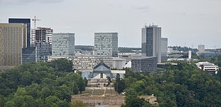
Kirchberg is a quarter in north-eastern Luxembourg City, in southern Luxembourg. It consists of a plateau overlooking the north-east of the historical city center, Ville Haute, connected to the rest of the elevated city by the Grand Duchess Charlotte Bridge, which spans the Pfaffenthal valley. It is often referred to, in reference to the geographical feature it inhabits, as the Kirchberg plateau by Luxembourgish residents. Kirchberg is the predominant location of the European Union institutions and bodies based within Luxembourg, and is sometimes used as a metonym for the EU's judiciary, which occupies the quarter. It is thus the central business district of Luxembourg.

Hollerich is a quarter in south-western Luxembourg City, in southern Luxembourg.

Belair is a quarter in western Luxembourg City, in southern Luxembourg.
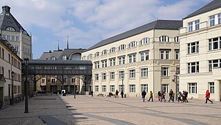
Ville Haute is a quarter in central Luxembourg City, in southern Luxembourg. It is the historic center of Luxembourg City and is involved in its UNESCO World Heritage Site status. As of 31 December 2022, Ville Haute has a population of 3,544 inhabitants.
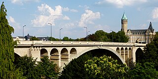
The Adolphe Bridge is a double-decked arch bridge in Luxembourg City, in southern Luxembourg. The bridge provides a one-way route for road traffic across the Pétrusse, from Boulevard Royal, in Ville Haute, to Avenue de la Liberté, on the Bourbon Plateau in Gare. Its upper deck is 153 m in length and carries two lanes of road traffic, and two pedestrian footpaths. Its lower deck, opened in 2018, suspended beneath the upper deck, is 154 m in length, and carries a dedicated bidirectional bicycle path, with access provided for pedestrian use. As of 13 December 2020, following the completion of the second phase of the construction of the city's new tramline, the bridge carries bidirectional tram traffic on its upper deck.

The Passerelle, also known as the Luxembourg Viaduct, is a viaduct in Luxembourg City, in southern Luxembourg. Nowadays it runs from the south into the city centre, Ville Haute, carrying road traffic across the Pétrusse valley and connecting Avenue de la Gare to Boulevard Franklin Delano Roosevelt. It is 290 m long, with 24 arches, and 45 m above the valley floor.

Avenue de la Liberté is a street in the Gare quarter of Luxembourg City, Luxembourg. Following significant alterations to its layout during renovation works, which occurred between 2018 and 2021, the avenue is separated into a dedicated bidirectional two-lane tramway on its eastern-side, followed by a two-lane one-way arterial road for motor vehicle traffic heading south towards Luxembourg station, and a bidirectional dedicated cycle-path on its western-side. All this is flanked by two wide tree-lined paved pedestrian footpaths. Prior to the works, which formed part of Luxembourg City's efforts to reintroduce tram transport, the avenue was a four-lane arterial road for motor vehicles with a one way designation for all traffic, excepting public buses.

The René Konen Tunnel, colloquially known as the Saint Esprit Tunnel, is a 655 m (2,149 ft) road tunnel in Luxembourg City in southern Luxembourg. It carries two lanes of one-way traffic northwards, under Ville Haute, bypassing the narrow streets and pedestrian zone in the heart of the city.

The N51 is a road in Luxembourg City, in southern Luxembourg. It is one of the city's main thoroughfares, carrying traffic from Ville Haute, through Kirchberg, to a junction with the A1. For the north-eastern three quarters of its length, on the eastern side of the Alzette, it bears the name Avenue John F. Kennedy. West of the Alzette, it is successively named Boulevard Robert Schuman ; Boulevard de la Foire; and Boulevard Grand-Duchesse Charlotte.

The N6 is a road in Luxembourg. It connects Luxembourg City, at its eastern end, to the Belgian border. At the border, it connects to the Belgian N4, which leads to Arlon, Namur, Wavre, and Brussels. It is also known by the name of route d'Arlon, due to the primary destination from Luxembourg City.

Saint Antoine Street, formerly known as Craig Street, is a street located in Montreal, Quebec, Canada. It runs to the south of Downtown Montreal and north of Old Montreal and Griffintown and Saint-Henri. It crosses the Quartier international de Montréal. Between Atwater Avenue and Greene Avenue, the north side of the street is in Westmount.

Robert Bourassa Boulevard, formerly named University Street, is a major north-south artery in downtown Montreal, Quebec, Canada that is 2.1 km (1.3 mi) in total length.
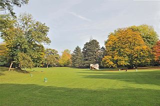
The Municipal Park is a public urban park in Luxembourg City, in southern Luxembourg. The eastern edge flanks the boulevard du Prince Henri and, along with the valleys of the Alzette and Pétrusse, forms a boundary that separates the central Ville Haute quarter from the rest of the city.
The Judiciary City is a site in Luxembourg City, in southern Luxembourg, that houses a number of courts and legal offices. It consolidates all of Luxembourg City's judicial buildings, except those related to the institutions of the European Union, on one site, and greatly expands their capacity.
The architecture of Luxembourg probably extends back to the Treveri, a Celtic tribe who prospered in the 1st century BC. A few ruins remain from the Roman occupation but the most significant contributions over the centuries have been the country's castles and churches. Today there is a veritable architectural boom as Luxembourg's economic prosperity provides a basis for developments in the financial, EU and cultural sectors with a number of world-class buildings.
The Cap-Rouge river is a river flowing on the north shore of the Saint-Laurent river at the height of the Sainte-Foy–Sillery–Cap-Rouge borough of Quebec City and in the city of Saint-Augustin-de-Desmaures, both cities in the administrative region of Capitale-Nationale, in the province of Quebec, Canada.

Côte-Sainte-Catherine Road is a street in Montreal, Quebec, Canada. It begins at the Décarie Expressway in Snowdon, part of the borough of Côte-des-Neiges–Notre-Dame-de-Grâce, and runs east and southeast along the periphery of Mount Royal to Park Avenue in the Plateau, terminating near Mount Royal Avenue. In between, it crosses Outremont completely and is one of the oldest streets in the borough, having been present at the time Outremont was incorporated in 1875. Outremont's borough hall is located on this street, as is Beaubien Park. Further west in Côte-des-Neiges, it houses the Jewish General Hospital, the CHU Sainte-Justine hospital, Collège Jean-de-Brébeuf, the Montreal Holocaust Museum, and the Segal Centre for Performing Arts.

The Bourbon Plateau is a plateau and neighbourhood of Luxembourg City that was named after the Fort Bourbon, part of the Fortress of Luxembourg.
