
Transport in Luxembourg is ensured principally by road, rail and air. There are also services along the river Moselle which forms the border with Germany. The road network has been significantly modernised in recent years with motorways to adjacent countries. The advent of the high-speed TGV link to Paris has led to renovation of the capital's main railway station while a new passenger terminal at Luxembourg Airport has recently been opened. Trams in the capital were reintroduced in December 2017 and there are plans for light-rail and/or tram-train lines in adjacent areas.

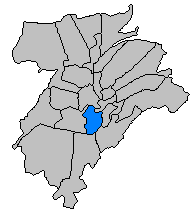
Luxembourg, also known as Luxembourg City, is the capital city of the Grand Duchy of Luxembourg and the country's most populous commune. Standing at the confluence of the Alzette and Pétrusse rivers in southern Luxembourg, the city lies at the heart of Western Europe, situated 213 km (132 mi) by road from Brussels, 372 km (231 mi) from Paris, and 209 km (130 mi) from Cologne. The city contains Luxembourg Castle, established by the Franks in the Early Middle Ages, around which a settlement developed.

Kirchberg is a quarter in north-eastern Luxembourg City, in southern Luxembourg. It consists of a plateau overlooking the north-east of the historical city center, Ville Haute, connected to the rest of the elevated city by the Grand Duchess Charlotte Bridge, which spans the Pfaffenthal valley. It is often referred to, in reference to the geographical feature it inhabits, as the Kirchberg plateau, or simply Kirchberg by Luxembourgish residents. Kirchberg is the predominant location of the European Union institutions and bodies based within Luxembourg, and is sometimes used as a metonym for the EU's judiciary, which occupies the quarter. It is thus the central business district of Luxembourg.

Limpertsberg is a quarter in north-western Luxembourg City, in the centre of Luxembourg.
Gare is a quarter in central Luxembourg City, in southern Luxembourg. The quarter has, since 1859, been the location of Luxembourg's principal railway station and terminus, Luxembourg station, around which it subsequently developed. The quarter's name translates into English, from the French Gare, to "station".
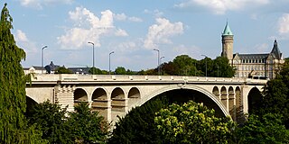
The Adolphe Bridge is a double-decked arch bridge in Luxembourg City, in southern Luxembourg. The bridge provides a one-way route for road traffic across the Pétrusse, from Boulevard Royal, in Ville Haute, to Avenue de la Liberté, in Gare. Its upper deck is 153 m in length and carries two lanes of road traffic, and two pedestrian footpaths. Its lower deck, opened in 2018, suspended beneath the upper deck, is 154 m in length, and carries a dedicated bidirectional bicycle path, with access provided for pedestrian use. As of 13 December 2020, following the completion of the second phase of the construction of the city's new tramline, the bridge carries bidirectional tram traffic on its upper deck.

The Passerelle, also known as the Luxembourg Viaduct, is a viaduct in Luxembourg City, in southern Luxembourg. Nowadays it runs from the south into the city centre, Ville Haute, carrying road traffic across the Pétrusse valley and connecting Avenue de la Gare to Boulevard Franklin Delano Roosevelt. It is 290 m long, with 24 arches, and 45 m above the valley floor.

Boulevard Royal is a street in Luxembourg City, in southern Luxembourg. The boulevard is a one-way arterial road that runs around the northern and western parts of the city centre, Ville Haute. Besides its importance as one of Luxembourg City's primary arteries, it is also the home of much of Luxembourg's large financial services industry, including the Banque Centrale du Luxembourg (No.2), Banque de Luxembourg (No.14), and Quintet Private Bank (No.43).
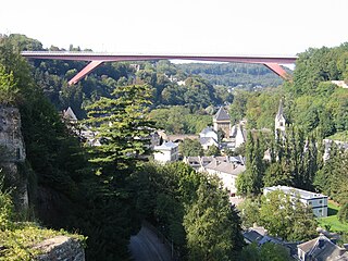
The Grand Duchess Charlotte Bridge is a road bridge in Luxembourg City, in southern Luxembourg. It carries the N51 across the Alzette, connecting Avenue John F. Kennedy, in Kirchberg, to Boulevard Robert Schuman, in Limpertsberg. The bridge is also known as the Red Bridge on account of its distinctive red paintwork. It is the main route connecting the city centre, Ville Haute, to Kirchberg, the site of the city's European Union institutions.

Avenue de la Liberté is a street in the Gare quarter of Luxembourg City, Luxembourg. Following significant alterations to its layout during renovation works, which occurred between 2018 and 2021, the avenue is separated into a dedicated bidirectional two-lane tramway on its eastern-side, followed by a two-lane one-way arterial road for motor vehicle traffic heading south towards Luxembourg station, and a bidirectional dedicated cycle-path on its western-side. All this is flanked by two wide tree-lined paved pedestrian footpaths. Prior to the works, which formed part of Luxembourg City's efforts to reintroduce tram transport, the avenue was a four-lane arterial road for motor vehicles with a one way designation for all traffic, excepting public buses.

The René Konen Tunnel, colloquially known as the Saint Esprit Tunnel, is a 655 m (2,149 ft) road tunnel in Luxembourg City in southern Luxembourg. It carries two lanes of one-way traffic northwards, under Ville Haute, bypassing the narrow streets and pedestrian zone in the heart of the city.

The N6 is a road in Luxembourg. It connects Luxembourg City, at its eastern end, to the Belgian border. At the border, it connects to the Belgian N4, which leads to Arlon, Namur, Wavre, and Brussels. It is also known by the name of route d'Arlon, due to the primary destination from Luxembourg City.
The European Parliament's presence in Kirchberg, Luxembourg currently consists of the Parliament's secretariat, although the Parliament had held plenary sessions in the city for a brief period.
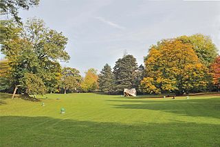
The Municipal Park is a public urban park in Luxembourg City, in southern Luxembourg. The eastern edge flanks the boulevard du Prince Henri and, along with the valleys of the Alzette and Pétrusse, forms a boundary that separates the central Ville Haute quarter from the rest of the city.

The Cercle Municipal or Cercle Cité is a building in Luxembourg City, in southern Luxembourg, It is located at the eastern end of the Place d'Armes, in the historic central Ville Haute quarter of the city.
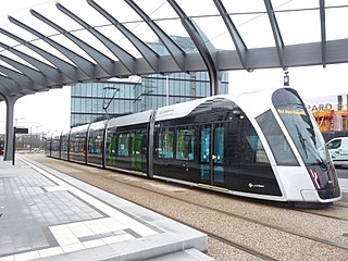
The first generation of trams in Luxembourg ran from 1875 to 1964, before being withdrawn from service and the tramways removed. A second generation of trams began operational service on 10 December 2017, along a new route that will, by 2023, run from Luxembourg Airport to the Cloche d'Or business district, in Gasperich, serving the new national stadium, via Pfaffenthal-Kirchberg and Luxembourg railway stations. Additional lines are planned for the network both within Luxembourg City, as well as extending to Strassen and Esch-sur-Alzette.

The Bock is a promontory in the north-eastern corner of Luxembourg City's old historical district. Offering a natural fortification, its rocky cliffs tower above the River Alzette, which surrounds it on three sides. It was here that Count Siegfried built his Castle of Lucilinburhuc in 963, providing a basis for the development of the town that became Luxembourg. Over the centuries, the Bock and the surrounding defenses were reinforced, attacked, and rebuilt time and time again as the armies of the Burgundians, Habsburgs, Spaniards, Prussians, and French vied for victory over one of Europe's most strategic strongholds, the Fortress of Luxembourg. Warring did not stop until the Treaty of London was signed in 1867, calling for the demolition of the fortifications. Ruins of the old castle and the vast underground system of passages and galleries known as the casemates continue to be a major tourist attraction.

Pfaffenthal-Kirchberg railway station is a rail station on CFL Line 10, in the north of Luxembourg City which opened in December 2017. It is located on Rue Saint-Mathieu in the Pfaffenthal valley, below the Grand Duchess Charlotte Bridge, overlooking the Alzette River. The Société Nationale des Chemins de Fer Luxembourgeois (CFL), the state-owned rail company, operates both it and the accompanying funicular line, which links the station to tram services on the Kirchberg plateau.

The Pfaffenthal Panoramic Elevator is a public elevator in Luxembourg City, Luxembourg which connects the city quarters of Ville Haute, the historical city center, with Pfaffenthal, in the Alzette valley below. It offers its passengers panoramic views of the Alzette River valley. The Pfaffenthal elevator, together with the Grund public elevator, and the Pfaffenthal-Kirchberg funicular, form Luxembourg City's three cable transport modes connecting its elevated city with city quarters located in the Alzette and Petrusse river valleys.


