The provinces of Burkina Faso are divided into 351 departments, whose urbanized areas are grouped into the same commune (municipality) with the same name as the department. The department also covers rural areas that are not governed locally by the elected municipal council of the commune, but by the state represented at departmental level by a prefect.

Balé is one of the 45 provinces of Burkina Faso, located in its Boucle du Mouhoun Region with Boromo as capital. Its area is 4,596 km2 (1,775 sq mi), and had a population of 297,367 in 2019. The province is known for its Deux Balé Forest, populated by savannah elephant herds. Boromo, the provincial capital, is located on the main road from Ouagadougou to Bobo-Dioulasso. In June 2007, the Canadian mining company, Semafo, open the third gold mine in the country in Mana in the province, with an investment of about $116 million.
Banwa is one of the 45 provinces of Burkina Faso and is in Boucle du Mouhoun Region. The capital of Banwa is Solenzo. In 2019 it had a population of 345,749.

Bazèga is one of the 45 provinces of Burkina Faso and is in Centre-Sud Region. The capital of Bazèga is Kombissiri. Bazèga had a population of 238,202 in 2006 and in 2011 it was estimated to be 263,603.

Bana is a department or commune of Balé Province in southern Burkina Faso. Its capital lies at the town of Bana. According to the 2019 census the department has a population of 19,787.
Pompoï is a department or commune of Balé Province in southern Burkina Faso. Its capital lies at the town of Pompoï. According to the 2019 census the commune has a total population of 14,067.

Sami is a department or commune of Banwa Province in western Burkina Faso. Its capital lies at the town of Sami. According to the 2019 census the department has a total population of 13,596.

Tiankoura is a department or commune of Bougouriba Province in south-western Burkina Faso. Its capital lies at the town of Tiankoura. According to the 2019 census the department has a total population of 14,681.

Bagré is a department or commune of Boulgou Province in eastern Burkina Faso. Its capital lies at the town of Bagré. According to the 2006 census, actualized for the municipal élections of 2019, the department has a total population of 37,855.
Bissiga is a department or commune of Boulgou Province in eastern Burkina Faso. Its capital lies at the town of Bissiga. According to the 1996 census the department has a total population of 26,183.

Komtoèga is a department or commune of Boulgou Province in eastern Burkina Faso. Its capital lies at the town of Komtoèga. According to the 2019 census the department has a total population of 27,144.

Bérégadougou is a department or commune of Comoé Province in southern Burkina Faso. Its capital lies at the town of Bérégadougou. According to the 2019 census the department has a total population of 15,164.
Moussodougou is a department or commune of Comoé Province in southern Burkina Faso. Its capital lies at the town of Moussodougou. According to the 2019 census the department has a total population of 17,288.
Ouo is a department or commune of Comoé Province in southern Burkina Faso. Its capital lies at the town of Ouo. According to the 1996 census the department has a total population of 45,170.
Soubakaniédougou is a department or commune of Comoé Province in south-western Burkina Faso. Its capital lies at the town of Soubakaniédougou. According to the 2019 census the department has a total population of 37,500.

The Bouroum Department is a department or commune of Namentenga Province in northern Burkina Faso. Its capital lies at the town of Bouroum.

Gossina is a department or commune of Nayala Province in western Burkina Faso. Its capital lies at the town of Gossina. According to the 1996 census the department has a total population of 17,945. In reference to the 2019 census, the population had seen a surge and was 26, 241. The male were 12,606 while the women were 13, 635.

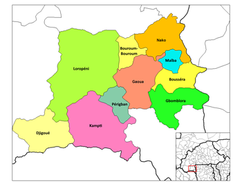
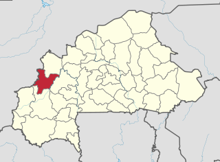
Loropeni is a department or commune of Poni Province in southern Burkina Faso. Its capital lies at the town of Loropeni.
Iolonioro is a department or commune of Bougouriba Province in south-western Burkina Faso. Its capital lies at the town of Iiolonioro. According to the 2019 census the department has a population of 35,351.
Bouroum-Bouroum is the capital of Bouroum-Bouroum Department in Poni Province, Burkina Faso. The main ethnic group is the Lobi.