The geography of France consists of a terrain that is mostly flat plains or gently rolling hills in the north and west and mountainous in the south and the east. Metropolitan France has a total size of 551,695 km2 (213,011 sq mi). It is the third largest country in Europe by area and the largest in Western Europe.

The Arctic Archipelago, also known as the Canadian Arctic Archipelago, is an archipelago lying to the north of the Canadian continental mainland, excluding Greenland and Iceland.

This is a list of the extreme points of Ireland – the points that are furthest north, south, east or west in Ireland. It includes the Republic of Ireland and Northern Ireland.

German submarine U-171 was a Type IXC U-boat of Germany's Kriegsmarine built for service during World War II. It was laid down on 1 December 1940 at the DeSchiMAG AG Weser yard at Bremen as yard number 1011, launched on 22 July 1941, and commissioned on 25 October 1941 under the command of Kapitänleutnant Günther Pfeffer.
In number theory, Mills' constant is defined as the smallest positive real number A such that the floor function of the double exponential function

Ares del Maestrat, also known as Ares del Maestre in Spanish or simply Ares, is a municipality in the province of Castelló in the Valencian Country. It is situated near the top of the Mola d'Ares mountain, at an elevation of 1,148 m.
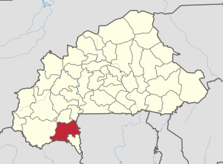
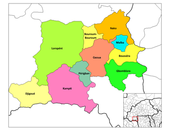
Poni is one of the 45 provinces of Burkina Faso, located in its Sud-Ouest Region.
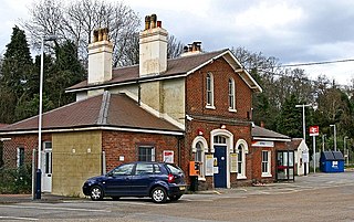
Witley railway station is a station on the Portsmouth Direct Line in Surrey, England. It is 38 miles 36 chains (61.9 km) down the line from London Waterloo via Woking.

The Royal Charter Storm of 25 and 26 October 1859 was considered to be the most severe storm to hit the Irish Sea in the 19th century, with a total death toll estimated at over 800. It takes its name from the Royal Charter ship, which was driven by the storm onto the east coast of Anglesey, Wales, with the loss of over 450 lives.

Gujranwala Division is an administrative division of Punjab province, Pakistan. The division, headquartered at the city of Gujranwala, consist of 3 districts, covers an area of 17,207 km2.

Villavaliente is a municipality in Albacete, Castile-La Mancha, Spain. It has a population of 279.
Campo de Gibraltar is a comarca (county) in the province of Cádiz, Spain, in the southwestern part of the autonomous community of Andalusia, the southernmost part of mainland Europe. It comprises the municipalities of Algeciras, La Línea de la Concepción, San Roque, Los Barrios, Castellar de la Frontera, Jimena de la Frontera and Tarifa.

Salqin is a town in Syria, administratively part of Idlib Governorate. Nearby localities include Kafr Takharim to the southeast, Abu Talha to the south, Delbiya to the southwest, al-Alani to the northwest and Isqat to the northeast. Salqin is the center of its nahiya (subdistrict). It had a population of 23,700 in 2004. Its inhabitants are predominantly Sunni Muslims, although there is also a small Alawite community.

Washington Air Route Traffic Control Center (ZDC) is an Area Control Center operated by the Federal Aviation Administration and located at Lawson Rd SE, Leesburg, Virginia, United States. The primary responsibility of ZDC is the separation of airplane flights and the expedited sequencing of arrivals and departures along STARs and SIDs for the Washington-Baltimore Metropolitan Area, the New York Metropolitan Area, and Philadelphia among many other areas.

Nenasi is a town in Pekan District, Pahang, Malaysia. Nenasi is a great area for camping, fishing and barbecue activities on the beach and forest. There are fisherman village, beach, swamps, rice fields, rivers and forest to explore. Nenasi also a famous place to watch firefly due to its natural swamps. Most of their residence work as a farmer and fisherman.
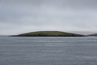
Fish Holm is a small island, 1.5 miles (2.4 km) east of Mainland, Shetland. It is near the village of Mossbank.

Công Bằng is a rural commune (xã) of Pác Nặm District, Bắc Kạn Province, in Vietnam.
Springhill is a small community in County Dublin, Ireland. It is located at a T-junction in the parish of Garristown, Dublin.
Lafond Bay is a bay, 3 nautical miles wide, which lies south of the Cockerell Peninsula, Trinity Peninsula, Antarctica.