San Pedro Columbia is a village in Toledo District, Belize, located about two miles from the ancient Maya ruins of Lubaantun. In 2000 San Pedro Columbia had a population of about 700 people. The population is mostly Q'eqchi Maya with some Mopan Maya. San Pedro Columbia has Belize's largest settlement of Kekchi. Most of the population came to Belize from the Petén region of Guatemala in the late 19th century. The village is known for the hand woven embroidery produced there.
This is a list of the extreme points of the United Kingdom: the points that are farther north, south, east or west than any other location. Traditionally the extent of the island of Great Britain has stretched "from Land's End to John o' Groats".
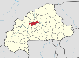
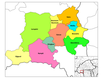
Passoré is one of the 45 provinces of Burkina Faso, located in its Nord Region. Its capital is Yako.
Aria is a village and municipality located in the province and autonomous community of Navarre, northern Spain.
The Battle of Kutná Hora (Kuttenberg) was an early battle and subsequent campaign in the Hussite Wars, fought on 21 December 1421 between German and Hungarian troops of the Holy Roman Empire and the Hussites, an early ecclesiastical reformist group that was founded in what is now the Czech Republic.
Tetsa River Provincial Park is a former provincial park in British Columbia, Canada. It is part of the larger Muskwa-Kechika Management Area. It is located on the north side of the Tetsa River at the confluence of Mill Creek, and is on the Alaska Highway.

Several air force stations and other establishments, many of them training facilities, operated in Calgary, Alberta, Canada, from the mid-1930s to the mid-1960s.
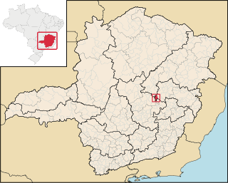
Dom Joaquim is a Brazilian municipality in the state of Minas Gerais. The city belongs to the mesoregion of Belo Horizonte and to the microregion of Conceição do Mato Dentro. As of 2020, the estimated population was 4,451.

Moussodougou is a department or commune of Comoé Province in southern Burkina Faso. Its capital lies at the town of Moussodougou. According to the 2019 census the department has a total population of 17,288.
Mebar is a village in the Diébougou Department of Bougouriba Province in south-western Burkina Faso. The village has a population of 982.
German submarine U-714 was a Type VIIC U-boat Nazi Germany's Kriegsmarine built for service during World War II. She was laid down on 29 December 1941 by H. C. Stülcken Sohn at Hamburg and commissioned on 10 February 1943. She was commanded throughout her career by Oberleutnant zur See Hans-Joachim Schwebcke.

Guinguinéo Department is one of the 45 departments of Senegal, and one of three which form the Kaolack Region. It was created by decree in 2008.
Nyanon is a town and commune in Cameroon.
Haltiala (Finnish), Tomtbacka (Swedish) is a northwestern neighborhood of Helsinki, Finland.

Kiota is a small town and rural commune in Niger in the Boboye Department, Dosso Region. As of 2012, it had a population of 25,282.
It is the seat of the most important Tijaniyyah community in Niger.
The weekly market is on Fridays.
Seykovtsi is a village in Gabrovo Municipality, in Gabrovo Province, in northern central Bulgaria.

Edru is a village in Väike-Maarja Parish, Lääne-Viru County, in northeastern Estonia.
The Prospect Hill neighborhood in North Omaha, Nebraska is one of the oldest neighborhoods in the city. In addition to being home to some of the city's oldest structures, the neighborhood is also the site of the Prospect Hill Cemetery which is located between North 31st and 33rd Streets and Parker and Grant Streets. The neighborhood's boundaries are North 30th Street from Hamilton Street to Lake and up to Creighton Boulevard; then over to Blondo and up to North 38th Street to Hamilton. The Omaha Belt Line ran near the northwest corner of the neighborhood. The neighborhood is also home to the historic Franklin Elementary School.
Dholan Railway Station is located in Pakistan.