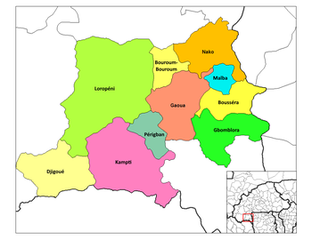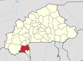
Poni is one of the 45 provinces of Burkina Faso, located in its Sud-Ouest Region.

Sanguié is one of the 45 provinces of Burkina Faso, located in its Centre-Ouest Region. In 2019 the population was 391,520. Its capital is Réo.
Dédougou is a city located in western Burkina Faso. It is the capital city of Mouhoun Province and Boucle du Mouhoun Region. The main ethnic groups are the Marka and the Bwa. The population of Dédougou was 37,793 in 2006; 18,778 were male and 19,015 were female. It is the 10th largest city in Burkina Faso.

Réo is a city located in the province of Sanguié in Burkina Faso. It is the capital of Sanguié Province, and is in its own department.

Bourzanga is a department of Bam Province in northern-central Burkina Faso. Its capital lies at Bourzanga town. According to the 2019 census the commune has a population of 103,266.

Sami is a department or commune of Banwa Province in western Burkina Faso. Its capital lies at the town of Sami. According to the 2019 census the department has a total population of 13,596.
Doulougou is a department or commune of Bazèga Province in central Burkina Faso. Its capital lies at the town of Doulougou. According to the 1996 census the department has a total population of 25,935.

Komtoèga is a department or commune of Boulgou Province in eastern Burkina Faso. Its capital lies at the town of Komtoèga. According to the 2019 census the department has a total population of 27,144.

Moussodougou is a department or commune of Comoé Province in southern Burkina Faso. Its capital lies at the town of Moussodougou. According to the 2019 census the department has a total population of 17,288.
Soubakaniédougou is a department or commune of Comoé Province in south-western Burkina Faso. Its capital lies at the town of Soubakaniédougou. According to the 2019 census the department has a total population of 37,500.
Yargo is the name of several villages in Burkina Faso, including the following:
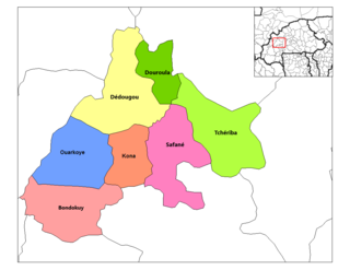
Dédougou is a department or commune of Mouhoun Province in western Burkina Faso. Its capital is the town of Dédougou. According to the 2019 census the department has a total population of 123,934.

Midebdo is a department or commune of Noumbiel Province in south-eastern Burkina Faso. Its capital lies at the town of Midebdo.

Oursi is a department or commune of Oudalan Province in northern Burkina Faso. Its capital lies at the town of Oursi.
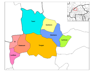
Lanfiera is a department or commune of Sourou Province in north-western Burkina Faso. Its capital lies at the town of Lanfiera.
Sangolo is a village in the Iolonioro Department of Bougouriba Province in south-western Burkina Faso. The village has a population of 502.
Batanga, Burkina Faso is a village in the Zimtenga Department of Bam Province in northern-central Burkina Faso. It has a population of 783.
Bonsiega is a town in the Liptougou Department of Gnagna Province in eastern Burkina Faso. The town has a population of 3,583.
Diaka, Burkina Faso is a town in the Thion Department of Gnagna Province in eastern Burkina Faso. The town has a population of 2,479.