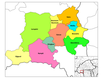
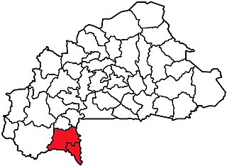
Gaoua is a market town in southern Burkina Faso known for its superstitious values and customs. The population, rested at 45,284. Located in the red earth, green hills, and fast flowing streams of southwestern Burkina Faso, Gaoua is the capital of Poni Province and forms a sort of capital for the sacred rites and bush lore of the Lobi peoples. According to local myth, Gaoua was founded when the Lobi migrated across from northern Ghana where they found the Gan people peoples occupying the territory. As a result, they named the trek across to Gaoua Gan-houo meaning "route of the Gan people".
Kekuli Bay Provincial Park, formerly Kalamalka West Provincial Park, is a provincial park in British Columbia, Canada, located on the west shore of Kalamalka Lake on BC Highway 97 south of Vernon. The lake is popular for waterskiing and boating, and the park includes a boat launch, as well as a campground with a view of the lake. The park was established in 1990. Its size is about 57 hectares.

Rebecca Spit Marine Provincial Park is a provincial park in British Columbia, Canada, located on the east side of Quadra Island, near the city of Campbell River.
Tahsish-Kwois Provincial Park is a provincial park in British Columbia, Canada. Located west of Woss Lake, it is approximately 10,829 ha. in size.

Sélibaby is a capital town and department of the Guidimaka Region, Mauritania. It is located at around 15°9′33″N12°11′00″W. It is divided into a number of "quartiers" which include "College", "Silo", 'Ferlo", "nezaha", "saada", "el jedida" "Bambaradougou" amongst many others. Selibaby also has a regional hospital, funded by the Chinese government and partially staffed by Chinese doctors and is the headquarters of the regional director of health. Selibaby is a centre for NGOs who operate in the region.
The Lower Similkameen Indian Band or Lower Smelqmix, is a First Nations band government in the Canadian province of British Columbia. Their office is located in the village of Keremeos in the Similkameen region. They are a member of the Okanagan Nation Alliance.

The Gwa'Sala-Nakwaxda'xw Nations are a union of two Kwakwaka'wakw peoples in a band government based on northern Vancouver Island in British Columbia, Canada, whose main reserve community is near the town of Port Hardy in the Queen Charlotte Strait region of the Central Coast region of British Columbia, Canada. The band government is a member of the Kwakiutl District Council and, for treaty negotiation purposes, the Winalagalis Treaty Group which includes three other members of the Kwakiutl District Council.

Río Iró is a municipality and town in the Chocó Department, Colombia.

Garden City is an unincorporated community in Columbus Township, Bartholomew County, in the U.S. state of Indiana.

Vilar de Canes is a municipality in the comarca of Alt Maestrat, Castellón, Valencia, Spain.
The Nazko First Nation is a First Nations government of the Dakelh people in the north-central Interior of British Columbia. Its reserves are located around the community of Nazko, British Columbia, which is 120 km west of Quesnel and southwest of Prince George.
The Compton Névé is an icefield in the Pacific Ranges of the Coast Mountains in southwestern British Columbia, Canada, located southeast of the Homathko Icefield and Mount Gilbert and to the south of the Bishop River. It lies west of the Lillooet Icecap and is connected to it by the Ring Glacier, which sits astride Ring Pass, the divide between the Lillooet and Bishop Rivers, and has an area of 714 km2 (276 sq mi).

The Katzie First Nation or Katzie Nation is the band government of the Katzie people of the Lower Fraser Valley region of British Columbia, Canada.
The Tahltan First Nation, also known as the Tahltan Indian Band, is a band government of the Tahltan people. Their main community and reserves are located at Telegraph Creek, British Columbia. Their language is the Tahltan language, which is an Athabaskan language also known as Nahanni, is closely related to Kaska and Dunneza. Their Indian and Northern Affairs Canada band number is 682. The Tahltan First Nation is joined with the Iskut First Nation in a combined tribal council-type organization known as the Tahltan Nation.
Serath is a hamlet in Saskatchewan.
Tlacuilotepec (municipality) is a town and municipality in Puebla in south-eastern Mexico.
The Leqʼ a꞉ mel First Nation, formerly known as the Lakahahmen First Nation, is a First Nations band government whose community and offices are located in the area near Deroche, British Columbia, Canada, about 12 kilometres east of the District of Mission. They are a member government of the Sto:lo Nation Chiefs Council, which is one of two tribal councils of the Sto:lo.
The Roman Catholic Diocese of Gaoua is a diocese located in the city of Gaoua in the Ecclesiastical province of Bobo-Dioulasso in Burkina Faso.

Fonfon Glacier is the 4 km long and 2.3 km wide glacier on the east side of the main crest of north-central Sentinel Range in Ellsworth Mountains, Antarctica. It is situated north of Gerila Glacier and south of the head of Embree Glacier. The glacier drains the northeast slopes of the northern summit of Long Gables Peak and the southeast slopes of Mount Anderson, flows northeastwards and joins upper Ellen Glacier southeast of Eyer Peak.
Division No. 1, Subdivision L is an unorganized subdivision on the Avalon Peninsula in Newfoundland and Labrador, Canada. It is in Division 1 and contains the unincorporated communities of Bareneed, Black Duck Pond, Blow Me Down, Coley's Point South, Hibb's Cove, Pick Eyes, Port de Grave, Ship Cove and The Dock