Bourtange moor

Last updated
The former Bourtange Swamp Bourtangermoeras.png
The former Bourtange Swamp
Bourtange fortification Fortbourtange.jpg
Bourtange fortification

The Bourtanger Moor (Dutch: Bourtangerveen/Bourtangermoeras, German: Bourtanger Moor, Low Saxon: Boertanger Moor) was a bog in eastern parts in the Dutch provinces of Drenthe and Groningen and the bordering German districts of Bentheim and Emsland. A remaining stretch on the border between Drenthe and the districts Emsland and Betheim is now a nature reserve, the Internationaler Naturpark Bourtanger Moor-Bargerveen.

Contents

Shape and size

The Bourtange Swamp had the shape of a V. The western leg covered the valley of the Hunze and ranged towards the city of Groningen. The western part was bordered by the Hondsrug. The eastern leg was located in the valley of the Ems. Between these two legs lays Westerwolde. At its greatest extent the swamp was about 3000 km2.

History

The swamp arose around 5000 BC. The area was already inhabited before this happened, as shown by archeological finds such as the one at Hoetsmansmeer in Groningen. These finds are attributed to nomads from the Mesolithic. Eventually these people left because of the growing swamp. Near Valthe - Ter Apel and Nieuw-Dordrecht remnants of roads through the bog were found, dating from the Neolithic to the Iron Age.

From a military point of view the swamp had an important function as a protective barrier, especially between 1580 and 1850. The swamp played an important role during the wars between Groningen and Münster In places with passages through or along the bog, strongholds were built. Bourtange, Oudeschans, Nieuweschans, Valtherschans and Emmerschans are examples of these places.

Cultivation

Initially cultivation only occurred at the edges of the swamp. The harvested peat was a source of fuel. During the second half of the Middle Ages the monasteries of Aduard and Essen played an important role in cultivating the bog. In the Middle Ages some places at the edges of the bog were drained for growing rye. The drainage caused soil settling and the area became more vulnerable to floodings. Between 1360 and 1500 parts in the northeast were washed away by the Dollart.

In the 16th century large-scale peat harvesting began. The Frisian method, using canals, was introduced. At first most peat harvesting was done at the river Hunze near the city of Groningen. The peat could be transported to the city via this small river. In the 17th century, Westerwolde came under control of the city of Groningen and the peat harvesting became more large-scaled Johan de la Haye and Johan Sems designed a line right through the western 'leg' of the bog, de Semslinie. De Semslinie is a straight line between Wolfsbarge (a village near the Zuidlaardermeer) and Ter Apel. Nowadays it is the border between Drenthe and the Province of Groningen.

The Stadskanaal (City canal), which was dug in the 18th century, largely follows the Semslinie. This canal played a significant role in the large-scale peat harvesting. The areas that were cultivated were called veenkoloniën (peat colonies).

Due to peat harvesting and drainage the remaining swamp became a lot drier. This was bad for the military function of the eastern branch. Therefore, dikes were built near Bourtange to keep water there.

Also colonists from Germany, who grew buckwheat, arrived in the Dutch part of the bog. In order to make the soil suitable to grow buckwheat the peat had to be burned. Because of the inconvenience it brought, it was banned in 1925.

During the 19th century peat as a fuel, got competition from coal and peat harvesting became less profitable. In the second half of the 19th century de another important canal was dug, the Verlengde Hoogeveensche Vaart. This resulted in more peat harvesting in the southern points of the bog. In the 20th century peat was no longer the main product from the bog, but activated charcoal, turfstrooisel (a sort of compost) and potting soil became important products. No new canals were dug and products from the bog was being largely transported to factories via narrow gauge railways. From there it was transported by ship, tram engine, train or truck. After the Amsterdamse Veld in southeast Drenthe was stripped of its peat, the harvesting of peat and other products from the bog stopped. A remaining part of the bog and surroundings including the Amsterdamse Veld are now part of the Bargerveen Nature Reserve, a Ramsar site. In Germany peat harvesting continued in the 21st century.

Bog bodies

Roter Franz Roter Franz Hannover.jpg
Roter Franz

Several bog bodies were found in the bog, including the Weerdinge Men (found near Weerdinge in Drenthe), Aschbroeken Man, also from Drenthe, Roter Franz (Neu Versen in Emsland) and the Kibbelgaarn body (Kibbelgaarn in Groningen)

Related Research Articles

<span class="mw-page-title-main">Groningen (province)</span> Northeasternmost province of the Netherlands

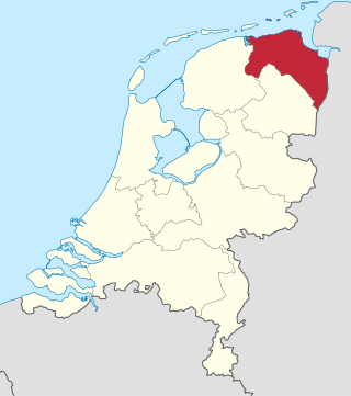
Groningen is the northeasternmost province of the Netherlands. It borders on Friesland to the west, Drenthe to the south, the German state of Lower Saxony to the east, and the Wadden Sea to the north. As of February 2020, Groningen had a population of 586,309 and a total area of 2,960 km2 (1,140 sq mi).

<span class="mw-page-title-main">Bellingwedde</span> Municipality in Groningen, Netherlands

Bellingwedde was a municipality with a population of in the province Groningen in the northeast of the Netherlands. Bellingwedde was established in 1968, when the municipalities of Bellingwolde and Wedde had merged. It contained the villages Bellingwolde, Blijham, Oudeschans, Veelerveen, Vriescheloo, and Wedde. After almost 50 year, Bellingwedde was disestablished in 2018, when the municipalities of Bellingwedde and Vlagtwedde had merged into Westerwolde.

<span class="mw-page-title-main">Hoogeveen</span> Municipality in Drenthe, Netherlands

Hoogeveen is a municipality and a town in the Dutch province of Drenthe.

Landkreis Emsland is a district in Lower Saxony, Germany named after the river Ems. It is bounded by the districts of Leer, Cloppenburg and Osnabrück, the state of North Rhine-Westphalia, the district of Bentheim in Lower Saxony, and the Netherlands.

<span class="mw-page-title-main">Bourtange</span> Village in Groningen, Netherlands

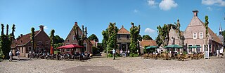
Bourtange is a village with a population of 430 in the municipality of Westerwolde in the Netherlands. It is situated in the region Westerwolde in the east of the province of Groningen near the German border. Fort Bourtange was built in 1593 during the Dutch Revolt and was used until 1851. Between 1967 and 1992 the star fort was gradually restored to its mid-18th-century state and it is currently an open-air museum.

<span class="mw-page-title-main">Barger-Compascuum</span> Village in Drenthe, Netherlands

Barger-Compascuum is a village in the Dutch municipality of Emmen. It is in a peat-producing region of Drenthe. Veenpark, an open-air museum, is dedicated to the peat history of the region.

<span class="mw-page-title-main">Ter Apel</span> Village in Groningen, Netherlands

Ter Apel is a village with a population of 8,866 residents in the municipality Westerwolde in the northern Netherlands, in the province Groningen in the region Westerwolde. The town lies on the stream Ruiten Aa, which has the valley that together with the Ter Apeler forest belongs to the national network of nature reserves, the Ecologische Hoofdstructuur. An accommodation centre for refugees is located at Ter Apel, functioning as a "departure centre" for rejected refugees and a registration point, operated by the Centraal Orgaan opvang Asielzoekers. Ter Apel lies on the roads N366, N976 and N391. It forms the southern point of the border between Groningen and Drenthe, the Semslinie.

<span class="mw-page-title-main">Twist, Germany</span> Municipality in Lower Saxony, Germany

Twist is a municipality in the Emsland district, in Lower Saxony, Germany. It is situated directly on the Dutch border.

<span class="mw-page-title-main">Eexterveenschekanaal</span> Village in Drenthe, Netherlands

Eexterveenschekanaal is a village in the Dutch province of Drenthe. It is a part of the municipality of Aa en Hunze, and lies about 19 km east of Assen.

<span class="mw-page-title-main">Sellingen</span> Village in Groningen, Netherlands

Sellingen is a village in the Dutch province of Groningen. It is a part of the municipality of Westerwolde, and lies about 25 kilometres (16 mi) northeast of Emmen. In 2021, statistical area "Sellingen", which also includes the surrounding countryside, had a population of 1,880, and the village of Sellingen had 1,045.

<span class="mw-page-title-main">Westhay Moor</span> Site of Special Scientific Interest

Westhay Moor is a 513.7-hectare (1,269-acre) biological Site of Special Scientific Interest 2.5 kilometres (1.6 mi) north-east of Westhay village and 4 kilometres (2.5 mi) from Wedmore in Somerset, England, notified in 1971. Westhay Moor is also notified as part of the Somerset Levels and Moors Special Protection Area under the EU Birds Directive and as a Ramsar site, and a National Nature Reserve.

<span class="mw-page-title-main">Emmer-Compascuum</span> Village in Drenthe, Netherlands

Emmer-Compascuum is a village in the Netherlands and is part of the Emmen municipality in Drenthe.

<span class="mw-page-title-main">Alteveer, Groningen</span> Village in Groningen, Netherlands

Alteveer is a village in the Dutch province of Groningen. It is largely located in the municipality Stadskanaal, about 7 km northeast of the centre of Stadskanaal. The houses on the western edge of the village are part of the municipality of Pekela. The name literally means "all too far".

<span class="mw-page-title-main">Raised bog</span>

Raised bogs, also called ombrotrophic bogs, are acidic, wet habitats that are poor in mineral salts and are home to flora and fauna that can cope with such extreme conditions. Raised bogs, unlike fens, are exclusively fed by precipitation (ombrotrophy) and from mineral salts introduced from the air. They thus represent a special type of bog, hydrologically, ecologically and in terms of their development history, in which the growth of peat mosses over centuries or millennia plays a decisive role. They also differ in character from blanket bogs which are much thinner and occur in wetter, cloudier climatic zones.

<span class="mw-page-title-main">Bargerveen Nature Reserve</span> Nature reserve in Drenthe, Netherlands

Bargerveen Nature Reserve is a nature reserve in the Dutch province of Drenthe that has been included in the Natura 2000 ecological network. Since 2006 it is part of the Internationaler Naturpark Bourtanger Moor-Bargerveen, a nature reserve located on both sides of the border between the Netherlands and Germany. Most of the transboundary nature reserve, some 134 km2 (52 sq mi), lies in Germany, in the west of the state of Lower Saxony. The sparsely populated landscape consists of large peat areas, heather, and small lakes.

<span class="mw-page-title-main">Semslinie</span>

The Semslinie is a part of the border between the Dutch provinces of Groningen and Drenthe that runs right through the former Bourtanger Moor. The almost straight line runs from Wolfsbarge to the Huis ter Haar at Musselkanaal. The border is slightly bent at Stadskanaal. The slightly bent line between Musselkanaal and Stadskanaal is sometimes called Koningsraai. The Semslinie is named after Johan Sems.

<span class="mw-page-title-main">Hunsingo</span>

Hunsingo is a region in the province of Groningen, Netherlands, between the Reitdiep and Maarvliet. Hunsingo was one of three Ommelanden. It is bordered to the north by the Wadden Sea, to the east Fivelingo, in the west to the Westerkwartier and Friesland and in the south, Gorecht. The region corresponds to the current municipalities De Marne, Eemsmond, the majority of the municipalities of Bedum and Winsum and the former municipality of Middelstum.

<span class="mw-page-title-main">Siege of Coevorden (1593)</span>

The siege of Coevorden was a thirty-one-week siege of the city of Coevorden in the province of Drenthe by the Spanish general Francisco Verdugo during the Eighty Years' War and the Anglo–Spanish War. The siege first commenced in October 1593, but winter and shortages of food and supplies forced the Spanish into winter quarters. The siege however recommenced in March 1594, but on May 6 Maurice of Orange arrived with an Anglo-Dutch army to relieve Coevorden, forcing the Spanish army under Francisco Verdugo to retreat.

<span class="mw-page-title-main">Zandberg, Groningen-Drenthe</span> Village in Netherlands

Zandberg is a village in the north of the Netherlands, partly located in the Groningen municipality of Westerwolde and partly in the Drenthe municipality of Borger-Odoorn. The village was created in the early nineteenth century as a settlement in the peat colonies. The first residents came from the neighboring part of Germany. Zandberg is therefore one of the Catholic enclaves in the Northern Netherlands.

<span class="mw-page-title-main">Musselkanaal</span> Town in Groningen, Netherlands

Musselkanaal is a town in the Dutch province of Groningen. It is located in the municipality of Stadskanaal. It was established by the city of Groningen in the 1840s to exploit the peat. It used to be part of the municipality of Onstwedde, but was merged into Stadskanaal in 1968.

References

    Coordinates: 52°53′45″N7°15′35″E / 52.89583°N 7.25972°E / 52.89583; 7.25972