The Kamnik–Savinja Alps are a mountain range of the Southern Limestone Alps. They lie in northern Slovenia, except for the northernmost part, which lies in Austria.

Grintovec is the highest mountain of the Kamnik–Savinja Alps, with an elevation of 2,558 metres (8,392 ft). It is a popular location for hiking, climbing and skiing. The first recorded ascent was in 1759 by the botanist Giovanni Antonio Scopoli.

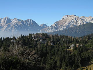
Kamniška Bistrica is a small dispersed settlement close to the source of the Kamnik Bistrica River in the Municipality of Kamnik in the Upper Carniola region of Slovenia.
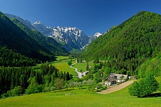
The Logar Valley is a valley in the Kamnik Alps, in the Municipality of Solčava, Slovenia. The Slovene name for the valley is of relatively recent coinage and is derived from the Logar Farm, which in turn is derived from log. In 1987, the valley received protected status as a landscape park encompassing 24.75 square kilometres (9.56 sq mi).

Logarska Dolina is a settlement in the Logar Valley in the Municipality of Solčava in northern Slovenia. The area belongs to the traditional region of Styria and is now included in the Savinja Statistical Region. 113 people lived in the settlement in 2020. The village is protected as an immovable cultural monument of local significance.
The Big Pasture Plateau is a karstified mountain plateau in the Kamnik–Savinja Alps northeast of Kamnik, Slovenia. It measures 5.8 square kilometres and has an average elevation of 1,500 metres above sea level. Its highest point is Mount Gradišče, at 1,666 m (5,466 ft). There are numerous herders' dwellings that comprise several settlement areas: Velika Planina 'Big Pasture', Mala Planina 'Little Pasture', Gojška Planina 'Gozd Pasture', Tiha Dolina 'Quiet Valley', and others. The Big Pasture Plateau is a tourist destination both in winter as a ski resort and in summer as a place for relaxation.

The Hochgolling is a mountain of the Eastern Alps, located on the border of Steiermark and Salzburg, Austria, near the ski resort of Schladming. It is the highest peak of the Lower Tauern range.

Kočna at 2,540 metres (8,330 ft) high, is the second-highest mountain in the Kamnik–Savinja Alps and the westernmost peak of the Grintovec Range. Its prominent and easily recognized peak is visible from far around. The mountain has two peaks: the higher Jezersko Kočna and the nearby lower Kokra Kočna.

Storžič is the highest mountain in the western part of the Kamnik–Savinja Alps. The top is a nicely shaped cone, from which the mountain got its name. Storžič has a good panoramic view. To the south are the Ljubljana Basin, Mount Krim, the Javornik Hills, Mount Snežnik, the Nanos Plateau, and the Škofja Loka Hills. To the west are the Julian Alps with prominent Mount Triglav. To the north are the Karawanks with Mount Stol, Mount Begunjščica, and Mount Košuta. To the east are the Jezersko Cirque, Mount Grintovec, the Kalce Ridge and Mount Krvavec.

Ojstrica is a mountain in the eastern part of the Kamnik Alps with a pyramid-shaped top that is visible from far away. The name Ojstrica derives from the Slovene word oster 'sharp'. There is a 600-meter (2,000 ft) high wall on its northern side to the bottom of the Logar Valley. The eastern side, down to the Roban Cirque, also has a high wall. There are several climbing routes.

Planjava is the highest mountain of the eastern Kamnik Alps in northern Slovenia. On the western side there is a steep wall over the Kamniško sedlo pass, on the eastern side runs a long ridge and on the northern side there is an almost 1,000-meter (3,300 ft) high wall above the Logar Valley.
Carinthia Mount Rinka or the Cross, with an elevation of 2,433 metres (7,982 ft), is a mountain in the central Kamnik–Savinja Alps in northern Slovenia. It is connected via a pass with Carniola Mount Rinka, the northern ridge descends to the Jezersko Pass and the Savinja Pass, whereas the western ridge with Styria Mount Rinka ends with the Turski Žleb Ravine. There is also the fourth Rinka, called Little Mount Rinka. The names of the mountains reflect their positions at the border between the traditional Slovene regions of Carinthia, Carniola, and Styria.
Cold Mountain is a 2,203-meter (7,228 ft) mountain in the Kamnik Alps. Cold Mountain rises over three valleys: the Logar Valley, the Matk Cirque, and the Vellach Combe. It is rarely visited because it is relatively difficult to ascend with many exposed areas. The border with Austria runs along the northern and western side, and until 1967 it was difficult to access because of political problems. Its first climbers had problems scaling it. In 1876, Robert von Lendenfeld and a guide named Matijevec from Luče reached the western peak and they descended, thinking they had reached the highest peak. In 1877, Karl Blodig tried two times, but quit due to weather well below the top. In the same year Johannes Frischauf, Piskernik, and Matek finally conquered the top. The Frischauf Lodge on Okrešelj is named after him.

Krofička is a mountain in the eastern part of the Kamnik Alps. Together with Ute Peak and nearby Strelovec Peak, it forms a barrier between the Logar Valley and the Roban Cirque. The southern part descends steeply to Škrbina, with which it is connected with Ojstrica. The eastern side is very steep, and grassy on the upper part, and on the western side it descends into a gorge. There is a nice panoramic view at the top.

The Kalce Ridge is a 2,224-metre-high (7,297 ft) mountain of the Kamnik–Savinja Alps in northern Slovenia. It is the highest peak of the Krvavec Group.

The Kamnik Saddle Lodge is a mountain hostel located just below Kamnik Saddle, with Mount Brana to its west and Mount Planjava to its east, and the Kamnik Bistrica Valley to its south. On its north is a steep descent toward the Logar Valley, home to Rinka Falls.

The Zois Lodge at Kokra Saddle is a mountain hostel that stands on Kokra Saddle, part of the Kamnik–Savinja Alps. It is named after the brothers Karl Zois (1756–1799), and Sigmund Zois (1747–1819).
The Frischauf Lodge at Okrešelj is a mountain lodge that stands above the Logar Valley in northern Slovenia. It is surrounded by the following peaks: Cold Mountain, Styria Mount Rinka, Carinthia Mount Rinka, and Mount Turska. Nearby is 80-meter (260 ft) Rinka Falls. The lodge is named after Johannes Frischauf, and the first lodge was built in 1876 by an Austro-German hiking club. In 1907 it was destroyed by an avalanche and rebuilt again in 1908. In 1991 it was expanded and modernized.

Begunjščica is a ridge mountain in the Karawanks. It rises from the western Smokuč mountain pasture to St. Anne on its eastern side. The mountain has three main peaks, the highest being Big Peak. The western Middle Peak lies a little lower, and the lowest is Begunje Mount Vrtača. Its southern slopes rise over the Draga Valley. The ascent of the mountain is relatively easy and possible throughout the year. In the winter and early spring conditions are favourable for ski touring.

The Matk Cirque, in older sources also the Jezera Valley is an Alpine glacial valley in Slovenia.


