Kvitsøy is an island municipality in Rogaland county, Norway. At only 6.29-square-kilometre (2.43 sq mi), it is the smallest municipality in Norway by area and one of the smallest by population. Kvitsøy is located in the traditional district of Ryfylke. The administrative centre of the municipality is the village of Ydstebøhamn on the island of Kvitsøy. The municipality is an archipelago located at the entrance to the large Boknafjorden. It sits about 2 nautical miles northwest of the mainland Stavanger peninsula. There are plans for the Rogfast tunnel to eventually connect Kvitsøy to the mainland road network.

Ulstein is a municipality in Møre og Romsdal county, Norway. It is part of the Sunnmøre region. The commercial and administrative centre of Ulstein is the town of Ulsteinvik. The municipality occupies the western half of the island of Hareidlandet, as well as about 30 smaller islands, four of which are populated.
Ørsta (help·info) is a municipality in Møre og Romsdal county, Norway. It is part of the Sunnmøre region of Western Norway. The administrative centre of the municipality is the village of Ørsta. Other villages in the municipality include Hovdebygda, Flåskjer, Leira, Liadal, Urke, Bjørke, Barstadvik, Åmdalen, Follestaddalen, Nordre Vartdal, Vartdal, Sæbø, Sætre, Store-Standal, and Ytre Standal.

Sula (help·info) is a municipality in Møre og Romsdal county, Norway. It is part of the Sunnmøre district. The administrative centre is the village of Langevåg. Other villages include Solevåg, Fiskarstrand, Veibust, Leirvågen, and Mauseidvågen. Sula is one of the most densely populated municipalities in Møre og Romsdal county, and it is part of the Ålesund Region since it is just south of the city of Ålesund. The municipality encompasses the island of Sula and the many small surrounding islets.

The Volcano Islands or Iwo Islands are a group of three Japanese islands south of the Bonin Islands that belong to the municipality of Ogasawara, Tokyo Metropolis, Japan. The islands are all active volcanoes lying atop an island arc that stretches south to the Marianas. They have an area of 32.55 square kilometres (12.57 sq mi), and a population of 380.
Måløy is a town and the administrative centre of the municipality of Vågsøy in Sogn og Fjordane county, Norway. Måløy is located on the southeastern side of the island of Vågsøy, about 3 kilometres (1.9 mi) northeast of the village of Holvika and about 6 kilometres (3.7 mi) south of the village of Raudeberg. The Måløy Bridge connects the town centre to the area of Deknepollen on the mainland. Sør-Vågsøy Church is located in Måløy.

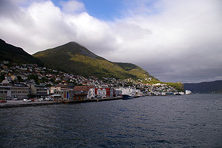
Ulsteinvik (help·info) is the commercial and administrative centre of the municipality (kommune) of Ulstein in Møre og Romsdal county, Norway. The 4.26-square-kilometre (1,050-acre) village has a population (2014) of 6,201; giving the village a population density of 1,456 inhabitants per square kilometre (3,770/sq mi). As such, Ulsteinvik contains 74% of the population of Ulstein Municipality. The town of Ulsteinvik is located on the west side of the island of Hareidlandet, about 23 kilometres (14 mi) southwest of the city of Ålesund. Ulstein Church is located in the town, serving the population of the whole municipality.

Leknes (help·info) is a town in Nordland county, Norway. The town is also the administrative centre of the municipality of Vestvågøy. Leknes was designated a "town" in 2002. The 2.52-square-kilometre (620-acre) town has a population (2018) of 3,556 which gives the town a population density of 1,411 inhabitants per square kilometre (3,650/sq mi).

Roald is a village in Giske Municipality in Møre og Romsdal county, Norway. The village is located on the northern part of the island Vigra. Roald is about 20 kilometres (12 mi) north of the city centre of Ålesund, connected via two undersea tunnels which opened in 1987. Ålesund Airport, Vigra is 2 kilometres (1.2 mi) south of the village of Roald. Vigra Church is located a short distance south of Roald.

Byrknes is a fishing village in the municipality of Gulen in Sogn og Fjordane county, Norway. It is located on the western shore of the island of Byrknesøyna. It is about 16 kilometres (9.9 mi) southwest of the municipal center of Eivindvik, about 17 kilometres (11 mi) west of the village of Dalsøyra, and about 14 kilometres (8.7 mi) northwest of the Mongstad industrial area in neighboring Lindås and Austrheim municipalities to the south. The Sognesjøen strait is located to the northwest of the village.

Raudeberg is a village in Vågsøy Municipality in Sogn og Fjordane county, Norway. It is located on the east side of the island of Vågsøy. The villages of Refvika, Vedvika, and Langeneset are located a few kilometers to the north, and the town of Måløy is about 6 kilometres (3.7 mi) to the south. The island of Silda is located about 2 kilometres (1.2 mi) northeast of the village of Raudeberg. Nord-Vågsøy Church is located on the eastern edge of the village, right along the coast.

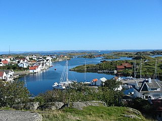
Sagvåg is a village in Stord municipality in Hordaland county, Norway. The village is located on the southwest coast of the island of Stord, about 5 kilometres (3.1 mi) west of the town of Leirvik. The Stord Airport, Sørstokken lies about 2 kilometres (1.2 mi) northwest of Sagvåg. Nysæter Church was built here in 1991 to serve the population of the village. The small mining village of Litlabø lies just northeast of Sagvåg.

Vågsvåg is a village in Vågsøy Municipality in Sogn og Fjordane county, Norway. It is located on the southern shore of the island of Vågsøy along the Vågsfjorden, a part of the main Nordfjorden. The village looks across the fjord towards the island of Husevågøy.
Haus or Hausvik is a village in Osterøy municipality in Hordaland county, Norway. The village is located on the southwestern coast of the island of Osterøy along the Sørfjorden. The village lies across the Sørfjorden from the villages of Ytre Arna and Garnes. The village of Valestrandfossen lies about 7 kilometres (4.3 mi) north along the fjord. The 0.38-square-kilometre (94-acre) village has a population (2013) of 619, giving the village a population density of 1,629 inhabitants per square kilometre (4,220/sq mi).

Rensvik is a village in Kristiansund Municipality in Møre og Romsdal county, Norway. The village is located on the northern part of the island of Frei, just west of the Omsund Bridge which connects to the island of Nordlandet to the north. The 1.65-square-kilometre (410-acre) village has a population (2013) of 2,501; which gives the village a population density of 1,516 inhabitants per square kilometre (3,930/sq mi).

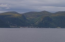
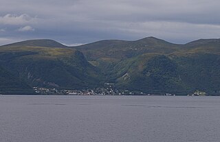
Hareid is the administrative centre of Hareid Municipality in Møre og Romsdal county, Norway. The village is located on the eastern coast of the island of Hareidlandet, along the Sulafjorden. The village has a shopping center, some industry, a hotel, and Hareid Church. The 2.53-square-kilometre (630-acre) village has a population (2013) of 3,245; giving the village a population density of 1,283 inhabitants per square kilometre (3,320/sq mi).

Sula (help·info) is an island in Sula Municipality in Møre og Romsdal county, Norway. The island are part of the Ålesund Region surrounding the city of Ålesund. The 59-square-kilometre (23 sq mi) island lies north of the Storfjorden, northeast of the Sulafjorden, and south of the Borgundfjorden. The island is connected to the nearby island of Uksenøya by a short bridge on the European route E39 highway. The island is mountainous, with almost all residents living in the northern and eastern shores. The southwestern half of the island is mountains, the highest being the 776-metre (2,546 ft) tall mountain Vardane. Most residents live in the municipal centre, Langevåg, in the north, and Fiskarstrand and Mauseidvåg are other large population centres. There are two churches on the island: Langevågen Church and Indre Sula Church.
Sulafjorden is a fjord in Sula Municipality in Møre og Romsdal county, Norway. It is located on the border of Sula Municipality and Hareid Municipality. The great Storfjorden flows out into the Sulafjorden which then flows out into the Breidsundet sound, and on into the ocean. The 9-kilometre (5.6 mi) long fjord is about 4 to 5 kilometres wide and it reaches a maximum depth of 445 metres (1,460 ft) below sea level. The island of Sula sits on the northeast side of the fjord and the island of Hareidlandet is to the southwest. The main settlements along the fjord include the villages of Brandal, Hareid, and Hjørungavåg, all on Hareidlandet. The island of Sula has very few inhabitants along the Sulafjorden.