Hareid is a municipality in Møre og Romsdal county, Norway. It is part of the Sunnmøre region. The administrative centre is the village of Hareid. The other main population centers are Brandal and Hjørungavåg.
Ørsta (help·info) is a municipality in Møre og Romsdal county, Norway. It is part of the Sunnmøre region of Western Norway. The administrative centre of the municipality is the village of Ørsta. Other villages in the municipality include Hovdebygda, Flåskjer, Leira, Liadal, Urke, Bjørke, Barstadvik, Åmdalen, Follestaddalen, Nordre Vartdal, Vartdal, Sæbø, Sætre, Store-Standal, and Ytre Standal.

Andøy is the northernmost municipality in Nordland county, Norway. It is part of the Vesterålen archipelago. The main island in the municipality is Andøya. The administrative centre of the municipality is the village of Andenes. Other villages in the municipality include Bjørnskinn, Bleik, Dverberg, Fiskenes, Fornes, Nordmela, Risøyhamn, Skarstein, Å, Åknes, and Åse.

Sula (help·info) is a municipality in Møre og Romsdal county, Norway. It is part of the Sunnmøre district. The administrative centre is the village of Langevåg. Other villages include Solevåg, Fiskarstrand, Veibust, Leirvågen, and Mauseidvågen. Sula is one of the most densely populated municipalities in Møre og Romsdal county, and it is part of the Ålesund Region since it is just south of the city of Ålesund. The municipality encompasses the island of Sula and the many small surrounding islets.
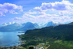
Brandal is a village in Hareid Municipality in Møre og Romsdal county, Norway. It is located on the eastern shores of the island of Hareidlandet, along the Sulafjorden. The village lies about 3.5 kilometres (2.2 mi) north of the municipal centre of Hareid and about 15 kilometres (9.3 mi) northeast of the town of Ulsteinvik on the other side of the island. The 0.3-square-kilometre (74-acre) village has a population (2013) of 346 people, giving the village a population density of 1,153 inhabitants per square kilometre (2,990/sq mi).

Gryllefjord is a fishing village and also the administrative centre of Torsken Municipality in Troms county, Norway. It is located on the island of Senja, along the Gryllefjorden in the northern part of the municipality. The 0.25-square-kilometre (62-acre) village has a population (2017) of 383 which gives the village a population density of 1,532 inhabitants per square kilometre (3,970/sq mi).

Sogndalsfjøra is the administrative center of the municipality of Sogndal in Sogn og Fjordane county, Norway. It is located where the river Sogndalselvi runs out in the Sogndalsfjorden, a branch of the large Sognefjorden. The village is located about 3.5 kilometres (2.2 mi) northwest of the village of Kjørnes, about 10 kilometres (6.2 mi) northwest of the village of Kaupanger, and about 31 kilometres (19 mi) southeast of the village of Fjærland.

Brandsøy (Brandsoy) is a village in the municipality of Flora in Sogn og Fjordane county, Norway. It is located on both sides of small strait that separates the east end of the island of Brandsøya and the mainland. The village sits along the Norwegian National Road 5 highway, about 6.9 kilometres (4.3 mi) east of the town of Florø and about 10 kilometres (6.2 mi) west of the village of Grov. The 0.4-square-kilometre (99-acre) village has a population (2013) of 420, giving the village a population density of 1,337 inhabitants per square kilometre (3,460/sq mi).

Birkeland is the administrative centre of the municipality of Birkenes in Aust-Agder county, Norway. The village is located on the eastern shore of the river Tovdalselva, across the river from the village of Flakk. The Norwegian National Road 41 runs through the village. The village is located about 30 kilometres (19 mi) northeast of the city of Kristiansand and about 14 kilometres (8.7 mi) northwest of Lillesand.

Hareidlandet is an island in Møre og Romsdal county, Norway. The island is divided between Hareid Municipality and Ulstein Municipality. The 166-square-kilometre (64 sq mi) island has a population (2008) of 11,687. The island is mentioned by Snorri in his reports about the Battle of Hjörungavágr in 986 where Haakon Jarl defeated Bue Digre and the Jomsvikings. The island is then referred to as Höð.

Huftarøy is the largest island in the municipality of Austevoll in Hordaland county, Norway. The 50.4-square-kilometre (19.5 sq mi) island lies in the Austevoll archipelago, just west of the Bjørnafjorden, south of the Korsfjorden, east of the Mokstrafjorden, and north of the Selbjørnsfjorden. The largest settlement on the island is the municipal centre of Storebø on the northern part of the island.
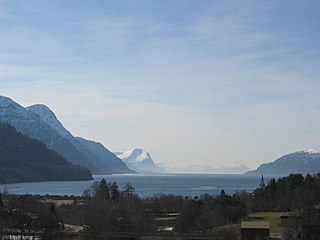
Storfjorden or Storfjord is a 110-kilometre (68 mi) long fjord in the Sunnmøre region of Møre og Romsdal county, Norway. It stretches from the village of Hareid in the west to the villages of Tafjord and Geiranger in the east. The Storfjorden system branches off into several smaller fjords including the famous Geirangerfjord and Tafjorden. At the village of Stranda, the main fjord branches off into the Sunnylvsfjorden-Geirangerfjorden to the west and the Norddalsfjorden-Tafjorden to the east.
Straume is the administrative center of Fjell municipality in Hordaland county, Norway. The village is located on the western part of the island of Litlesotra, just south of the village of Foldnes and southwest of the village of Knarrvika. Straume is the centre of government for the municipality and it is also the centre of commerce for the municipality. The large Sartor Senter, a regional shopping center is located in Straume.

Svortland or Bremnes is the administrative centre of Bømlo municipality in Hordaland county, Norway. The village is located in the north-central part of the island of Bømlo, about 6 kilometres (3.7 mi) west of the village of Rubbestadneset. The village surrounds the lake Storavatnet. The Norwegian County Road 542 runs through the village.

Aure is the administrative centre of Aure Municipality in Møre og Romsdal county, Norway. The village is located on the mainland, along the Aursundet strait. The 0.53-square-kilometre (130-acre) village has a population (2013) of 640, which gives the village a population density of 1,208 inhabitants per square kilometre (3,130/sq mi).

Sula (help·info) is an island in Sula Municipality in Møre og Romsdal county, Norway. The island are part of the Ålesund Region surrounding the city of Ålesund. The 59-square-kilometre (23 sq mi) island lies north of the Storfjorden, northeast of the Sulafjorden, and south of the Borgundfjorden. The island is connected to the nearby island of Uksenøya by a short bridge on the European route E39 highway. The island is mountainous, with almost all residents living in the northern and eastern shores. The southwestern half of the island is mountains, the highest being the 776-metre (2,546 ft) tall mountain Vardane. Most residents live in the municipal centre, Langevåg, in the north, and Fiskarstrand and Mauseidvåg are other large population centres. There are two churches on the island: Langevågen Church and Indre Sula Church.
Vartdalsfjorden is a fjord in Møre og Romsdal county, Norway. It begins at the Storfjorden and Sulafjorden in the northeast and flows through Hareid Municipality and Ulstein Municipality on the northern shore of the fjord and through Ørsta Municipality and Volda Municipality on the southern shore. The 20-kilometre (12 mi) long fjord has one road crossing, the Eiksund Tunnel. The deepest part of the fjord reaches 365 metres (1,198 ft) below sea level. The village of Vartdal lies on the southern shore of the fjord in Ørsta Municipality. From 1895 until 1964, the southern banks of the fjord were part of Vartdal Municipality.