
Sir George Gilbert Scott, known as Sir Gilbert Scott, was a prolific English Gothic Revival architect, chiefly associated with the design, building and renovation of churches and cathedrals, although he started his career as a leading designer of workhouses. Over 800 buildings were designed or altered by him.

Campion Hall is one of the six Permanent Private Halls of the University of Oxford in England. It is run by the Society of Jesus and named after St. Edmund Campion, a martyr and fellow of St John's College, Oxford. The hall is located on Brewer Street, between Christ Church and Pembroke College. The buildings, along with many of the fixtures and fittings, were designed by Sir Edwin Lutyens, his only buildings in Oxford. The hall also houses an extensive collection of religious art spanning 600 years; the pieces were collected primarily by Fr Martin D'Arcy in the 1930s.

Carfax is the junction of St Aldate's (south), Cornmarket Street (north), Queen Street (west) and the High Street (east) in Oxford, England. It is considered to be the centre of the city. The name "Carfax" derives from the Latin quadrifurcus via the French carrefour, both of which mean "crossroads". The Carfax Tower, also known as St. Martin's Tower is a prominent landmark and provides a look-out over the town.

Sir Arthur William Blomfield was an English architect. He became president of the Architectural Association in 1861; a Fellow of the Royal Institute of British Architects in 1867 and vice-president of the RIBA in 1886. He was educated at Trinity College, Cambridge, where he read Architecture.

Christ Church Meadow is a flood-meadow and popular walking and picnic spot in Oxford, England.

St Ebbe's is a Church of England parish church in central Oxford. The church is within the conservative evangelical tradition and participates in the Anglican Reform movement. It has members from many nations, many of whom are students at Oxford University. The rector is Vaughan Roberts who is also an author and conference speaker.

The Meadow Building is part of Christ Church, Oxford, England, one of the Oxford colleges, looking out south onto Christ Church Meadow on Broad Walk and then along the straight tree-lined Poplar Walk to the River Thames.

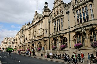
The High Street in Oxford, England, known locally as the High, runs between Carfax, generally seen as the centre of the city, and Magdalen Bridge to the east.
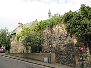
St Aldate's is a street in central Oxford, England, named after Saint Aldate, but formerly known as Fish Street.
Charles Eamer Kempe was a Victorian era designer and manufacturer of stained glass. His studios produced over 4,000 windows and also designs for altars and altar frontals, furniture and furnishings, lichgates and memorials that helped to define a later nineteenth-century Anglican style. The list of English cathedrals containing examples of his work includes: Chester, Gloucester, Hereford, Lichfield, Wells, Winchester and York. Kempe's networks of patrons and influence stretched from the Royal Family and the Church of England hierarchy to the literary and artistic beau monde.

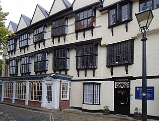
Alfred Street is a street running between the High Street to the north and the junction with Blue Boar Street and Bear Lane at the southern end, in central Oxford, England. To the south is Christ Church, one of Oxford University's historic colleges.
St Ebbes is a district of central Oxford, England, southwest of Carfax. St Ebbes Street runs south from the western end of Queen Street.

Christ Church Cathedral School is an independent preparatory school for boys in Oxford, England. It is one of three choral foundation schools in the city and educates choristers of Christ Church Cathedral, and the Chapels of Worcester College and Pembroke College. It is a member of the IAPS and the Choir Schools Association.

Oxpens Road is a road in central Oxford, England, linking west and south Oxford. It is named after the marshy area of Oxpens, next to one of the branches of the River Thames in Oxford. It forms part of the A420 road.

St Aldate's is a Church of England parish church in the centre of Oxford, in the Deanery and Diocese of Oxford. The church is on the street named St Aldate's, opposite Christ Church college and next door to Pembroke College. The church has a large congregation and has a staff team of about 30 which includes clergy, pastoral and administrative staff. The offices of the Rector and other members of staff are at 40 Pembroke Street.

New Road is a street in west central Oxford, England. It links Park End Street and Worcester Street to the west with Queen Street and Castle Street to the east. To the south is Oxford Castle and the former Oxford Prison, now a Malmaison hotel. To the north is Nuffield College, a graduate college of Oxford University. At the eastern end on the south side is New County Hall, the headquarters of Oxfordshire County Council.

Fyfield Road is a residential road in North Oxford, England, on the Norham Manor estate.

Christ Church War Memorial Garden is a garden in Oxford, England, created in 1926 to commemorate the First World War.
Oxford University Catholic Chaplaincy is based in the Old Palace, also known as Bishop King's Palace. The chaplaincy started in 1896 and moved into its current premises in 1920. The building was originally constructed in 1485 with another part added to it from 1622. It is situated on the corner of Rose Place and St Aldate's, next to Christ Church Cathedral School and Campion Hall. It is a Grade I listed building.


