Related Research Articles

Milam County is a county located in the U.S. state of Texas. As of the 2020 census, its population was 24,754. The county seat is Cameron. The county was created in 1834 as a municipality in Mexico and organized as a county in 1837. Milam County is named for Benjamin Rush Milam, an early settler and a soldier in the Texas Revolution.

Kasigluk is a census-designated place (CDP) in the Bethel Census Area in the U.S. state of Alaska. At the 2010 census the population was 569, up from 543 in 2000. Kasigluk consists of two smaller villages, called Akiuk and Akula.
Napoli is a town in Cattaraugus County, New York, United States. It is located in the western half of the county, northwest of Salamanca. The only permanent community in the town is Napoli village, formerly "Napoli Corners". The population was 1,173 at the 2020 census.

Folsom is a census-designated place (CDP) in Delaware County, Pennsylvania, United States. It is part of Ridley Township. The population was 8,323 at the 2010 census.

Clarksville is a borough in Greene County, Pennsylvania, United States. The population was 194 at the 2020 census.

Fairview is a town in Collin County, Texas, United States. It is part of the Dallas-Fort Worth metropolitan area. As of the 2017 census, the town population was 8,950. The estimated population in 2018 was 9,092. The town is adjacent to the 289-acre (1.17 km2) Heard Natural Science Museum and Wildlife Sanctuary.
Claybank is a small hamlet in the southern part of the Canadian province of Saskatchewan at the foot of the Dirt Hills. The community is named for the rich clay deposits found in the area. Claybank is best known for its National Historic Site of Canada, the Claybank Brick Plant, which closed in 1989 but remains one of the finest examples of 20th century industry. It is part of the RM of Elmsthorpe No. 100.
Ohio's 5th congressional district is in northwestern and north central Ohio and borders Indiana. The district is currently represented by Republican Bob Latta.
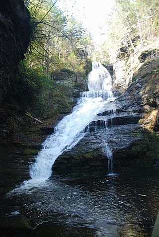
Dingmans Falls is a waterfall located in Dingmans Ferry in Delaware Township, Pennsylvania near the Silverthread Falls. It has a vertical drop of 39.6 m (130 ft). Both Silverthread Falls and Dingmans Falls are visible from a handicap-accessible trail. The trail begins at the parking lot for the Dingmans Falls Visitor Center.

Dúbravka is a village and municipality in Michalovce District in the Košice Region of eastern Slovakia.

The Brownsville & Matamoros International Bridge, also known as B&M International Bridge, Brownsville-Matamoros International Bridge and Express Bridge, is one of three international bridges that cross the U.S.-Mexico border between the cities of Brownsville, Texas, and Matamoros, Tamaulipas. This international bridge unites the Matamoros–Brownsville Metropolitan Area, which counts with a population of 1,136,995, making it the 4th largest metropolitan area in the Mexico-US border.

Lake Lashaway is a 293-acre (1.19 km2) pond located near the East Brookfield and North Brookfield, Massachusetts town line. The Lake Lashaway Community Association’s website is www.LakeLashaway.org. The town line cuts the lake approximately in half. The lake lies just to the north of state Route 9 as it passes through East Brookfield.
WMST is a radio station serving the Lexington-Fayette metropolitan area with an adult standards/soft AC format fed from Westwood One's Adult Standards satellite feed and is under ownership of Gateway Radio Works, Inc.

The Tohono Oʼodham Indian Reservation, is an Indian reservation of the Tohono Oʼodham Nation located in Arizona, United States. The reservation had a total 2000 census population of 10,787. The reservation has a land area of 4,340.984 square miles (11,243.098 km2), 97.48 percent of the Tohono Oʼodham Nation total area. The reservation encompasses portions of central Pima, southwestern Pinal, and southeastern Maricopa Counties.
Rootok Island (also called Aektok, Aiaktak, Ouektock, Aiaiepta, Veniaminof, or Goloi is the smallest member of the Krenitzin Islands, a subgroup of the Fox Islands in the eastern Aleutian Islands in Alaska, United States. The island's common spelling of Rooktok appears to have arisen from Aektok. Deviations in compass readings of up to 3 degrees from normal have been observed off the island's north-western side. The island was set aside to house a lighthouse on January 4, 1901; though no navigation aids were ever constructed. The island is uninhabited and it is 6.3 kilometres long and 6.2 kilometres wide.
Mount Tremper is a hamlet in the Town of Shandaken in Ulster County, New York, United States. Mount Tremper is situated to the east of New York State Route 28 and to the north of New York State Route 212, within the Catskill Park. The community is located at 42°02′41″N74°16′32″W. It is named for nearby Mount Tremper.
Jèkafo is a small town and commune in the Cercle of Dioila in the Koulikoro Region of southern Mali. As of 1998 the commune had a population of 5,138.

Bartlett is an unincorporated community in Ramsey County, North Dakota, United States. In recent years, the town's population has dwindled.
Delaneysville is a ghost town in Coshocton County, in the U.S. state of Ohio.

A split intersection is a rarely built at-grade variant of the diamond interchange. Compared to a conventional four-leg intersection or road crossing, the arterial road is split into separate carriageways by 200 to 300 feet, allowing a queue of left turning vehicles behind a completed turn into the crossroad without any conflict to oncoming traffic. On the crossroad, the four leg intersection is being replaced by two intersections. The beginning one-way traffic at the fourth leg makes the intersections reduce the number of conflicts similar to a three leg T-intersection to improve traffic flow.
References
Municipalities and communities of Milam County, Texas, United States | ||
|---|---|---|
| Cities |  | |
| Town | ||
| CDPs | ||
| Other communities | ||
| Ghost towns | ||
| Footnotes | ‡This populated place also has portions in an adjacent county or counties | |
31°02′41″N96°53′31″W / 31.04472°N 96.89194°W
| | This article about a location in Milam County, Texas is a stub. You can help Wikipedia by expanding it. |