
Dewsbury is a market town in the Metropolitan Borough of Kirklees in West Yorkshire, England. It lies on the River Calder and on an arm of the Calder and Hebble Navigation waterway. It is to the west of Wakefield, east of Huddersfield and south of Leeds. Historically a part of the West Riding of Yorkshire, after undergoing a period of major growth in the 19th century as a mill town, Dewsbury went through a period of decline. Dewsbury forms part of the Heavy Woollen District of which it is the largest town. The population of the built-up area was 63,722 at the 2021 Census.

Thornhill is a village on the southern outskirts of Dewsbury in Kirklees, West Yorkshire, England. Historically part of the West Riding of Yorkshire, Thornhill was absorbed into Dewsbury County Borough in 1910. The village is located on a ridge on the south side of the River Calder. Dewsbury, Ossett and Wakefield are close by. Its parish church houses a collection of Anglo-Saxon crosses.
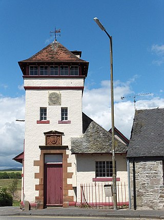
Thornhill is a village in the Scottish council area of Stirling. It lies 14 miles north west of Stirling itself, south of Callander, east of Aberfoyle and west of Doune.

Islington was a civil parish and metropolitan borough in London, England. It was an ancient parish within the county of Middlesex, and formed part of The Metropolis from 1855. The parish was transferred to the County of London in 1889 and became a metropolitan borough in 1900. It was amalgamated with the Metropolitan Borough of Finsbury to form the London Borough of Islington in Greater London in 1965.

Dewsbury was a constituency created in 1868 and abolished in 2024.
Ravensthorpe is an area of Dewsbury, in West Yorkshire, England. Historically part of the West Riding of Yorkshire, Ravensthorpe is on the western outskirts of Dewsbury and is part of the "Dewsbury West" ward in the district of Kirklees. The area has always been heavily industrial and was once bustling with textile mills.

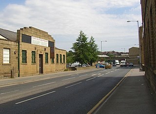
Ravensthorpe railway station serves the Ravensthorpe suburb of Dewsbury in West Yorkshire, England. It is situated on the Huddersfield line between Leeds and Manchester, 8 miles (13 km) north east of Huddersfield.

Dewsbury railway station serves the town of Dewsbury in West Yorkshire, England. Situated 9.25 miles (15 km) south west of Leeds on the main line to Huddersfield and Manchester, the station was opened by the London and North Western Railway in 1848.

East Morton is a village in the civil parish of Keighley, in the Bradford district, in the county of West Yorkshire, England. It lies 2 miles (3 km) north of Bingley and 2.5 miles (4 km) east of Keighley. The small hamlet of West Morton lies 1 mile (1.6 km) to the north west. The village has a population of 1,169 according to the 2011 census.

Agbrigg and Morley was a wapentake of the West Riding of Yorkshire, England. The main purpose of the wapentake was the administration of justice by a local court. At the time of the Domesday survey in 1086, Agbrigg and Morley were separate wapentakes. For example, Methley was in Agbrigg, while Rothwell was in Morley.

Whitley is a civil parish in the unitary authority of Cheshire West and Chester and the ceremonial county of Cheshire, England. It is surrounded by the parishes of Antrobus, Comberbach, Little Leigh and Dutton. It also borders Daresbury in Halton borough as well as Hatton and Stretton in Warrington borough. It is a small village located next to Antrobus.

Agbrigg is a suburb of the city of Wakefield, West Yorkshire, England.
St Luke's Church is in the village of Lower Whitley, in the civil parish of Whitley, Cheshire, England. The church is recorded in the National Heritage List for England as a designated Grade II* listed building. It is an active Anglican parish church in the diocese of Chester, the archdeaconry of Chester and the deanery of Great Budworth. It is one of three parish churches in the parish of Aston-by-Sutton, Little Leigh and Lower Whitley. The other two being St Peter, Aston-by-Sutton and St Michael and All Angels, Little Leigh. The three were previously individual parishes in a united benefice with St Mark, Antrobus.

Stanton in Peak is a village in the Derbyshire Dales district of Derbyshire, It is about seven miles north-west of Matlock, on the north side of Stanton Moor, from Birchover. The name of the civil parish is Stanton with a population taken at the 2011 census of 365. There is a 19th-century parish church, and many stone houses, with mullion windows. There is also a stately home, Stanton Park, a combination of the English Classical style, and later Palladian alterations, which is a private house.

Thornhill Railway station, as it was latterly known since the closure (1930) of its sister Market Place Passenger Station in the town centre; was located between Mirfield and Horbury and Ossett stations.

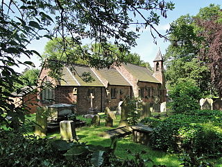
Whitley Lower is a village near Thornhill in Kirklees, West Yorkshire England. The parish church, dedicated to St Mary and St Michael, is part of the united benefice of Thornhill and Whitley which also includes Briestfield. The church was Grade II listed in 1985. In 1891 the civil parish had a population of 879.

Higher Whitley is a village and former civil parish, now in the parish of Whitley, in the unitary authority area of Cheshire West and Chester, in the ceremonial county of Cheshire, England. In 1931 the parish had a population of 339. It is north of Lower Whitley.
Dennis Trotter was an English professional rugby league footballer who played in the 1970s and 1980s. He played at club level for Bradford Northern, as a second-row.
Dewsbury is a town and an unparished area in the metropolitan borough of Kirklees, West Yorkshire, England. It contains 134 listed buildings that are recorded in the National Heritage List for England. Of these, two are listed at Grade I, the highest of the three grades, three are at Grade II*, the middle grade, and the others are at Grade II, the lowest grade. The list consists of the listed buildings in the town and the countryside to the south, and includes the districts, villages and smaller settlements of Boothroyd, Briestfield, Hanging Heaton, Overthorpe, Ravensthorpe, Thornhill, and Whitley Lower.

