Originally Bright's Shade was the home of husband and wife Wiley (born 1838) and Ester Bright, and used as a stopping point for people travelling the creek.[2] Coming from Knox County, they had settled at the mouth of Otter Creek on Goose Creek in 1862.[2] Postmaster Milton L. Albertson took the name for the postoffice that he established there on 1883-08-06, although the USPS removed the possessive and combined the two words into one.[2]
It was located at that and several other points along Goose Creek during its lifetime through to 1984, moving progressively upstream.[2] In 1888 it was a mile upstream, by 1898 a further 1.5 miles (2.4km) at the mouth of the tributary that is now Mud Lick but was then known as Timbertree Creek, and by 1906 reaching its final location four miles upstream at the mouth of tributary Mill Creek.[2]
Clay County is a county located in the U.S. state of Kentucky. As of the 2010 census, the population was 21,730. Its county seat is Manchester. The county was formed in 1807 and named in honor of Green Clay (1757–1826). Clay was a member of the Virginia and Kentucky State legislatures, first cousin once removed of Henry Clay, U.S. Senator from Kentucky and Secretary of State in the 19th century.
Manchester is a home rule-class city in Clay County, Kentucky, in the United States. It is the seat of its county and the home of a minimum- and medium-security federal prison. The city's population was 1,255 at the 2010 census.
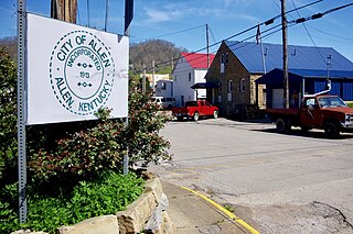
Allen is a home rule-class city in Floyd County, Kentucky, in the United States. The population was 193 at the 2010 census, up from 150 at the 2000 census.
Wayland is a home rule-class city in Floyd County, Kentucky, United States. The population was 426 at the 2010 census, up from 298 at the 2000 census.
Goose Creek is a home rule-class city in Jefferson County, Kentucky, United States. The population was 294 at the 2010 census.
The Tennessee River is the largest tributary of the Ohio River. It is approximately 652 miles (1,049 km) long and is located in the southeastern United States in the Tennessee Valley. The river was once popularly known as the Cherokee River, among other names, as the Cherokee people had their homelands along its banks, especially in what are now East Tennessee and northern Alabama. In addition, its tributary the Little Tennessee River, flowed into it from Western North Carolina and northeastern Georgia, where it also was bordered by numerous Cherokee towns. Its current name is derived from the Cherokee town, Tanasi, which was located on the Tennessee side of the Appalachian Mountains.
The Kentucky River is a tributary of the Ohio River, 260 miles (418 km) long, in the U.S. Commonwealth of Kentucky. The river and its tributaries drain much of the central region of the state, with its upper course passing through the coal-mining regions of the Cumberland Mountains, and its lower course passing through the Bluegrass region in the north central part of the state. Its watershed encompasses about 7,000 square miles (18,000 km2). It supplies drinking water to about one-sixth of the population of the Commonwealth of Kentucky.
The Christina River is a tributary of the Delaware River, approximately 35 miles (56 km) long, in northern Delaware in the United States, also flowing through small areas of southeastern Pennsylvania and northeastern Maryland. Near its mouth the river flows past downtown Wilmington, Delaware, forming the city's harbor for traffic on the Delaware River. The Port of Wilmington, opened in 1923 at the river's mouth, handles international cargo and trade.
Muncy Creek is a tributary of the West Branch Susquehanna River in Sullivan County and Lycoming County, at Pennsylvania, in the United States. It is approximately 34.5 miles (55.5 km) long. The watershed of the creek has an area of 216 square miles (560 km2). The creek's discharge averages 49 cubic feet per second (1.4 m3/s) at Sonestown, but can be up to a thousand times higher at Muncy. The headwaters of the creek are on the Allegheny Plateau. Rock formations in the watershed include the Chemung Formation and the Catskill Formation.
Goose Creek is a 53.9-mile-long (86.7 km) tributary of the Potomac River in Fauquier and Loudoun counties in northern Virginia. It comprises the principal drainage system for the Loudoun Valley.
Chillisquaque Creek is a tributary of the West Branch Susquehanna River in Montour County and Northumberland County, in Pennsylvania, in the United States. It is approximately 20.2 miles (32.5 km) long and flows through Derry Township, Washingtonville, and Liberty Township in Montour County and East Chillisquaque Township and West Chillisquaque Township in Northumberland County. The watershed of the creek has an area of 112 square miles (290 km2). Agricultural impacts have caused most of the streams in the watershed of the creek to be impaired. Causes of impairment include sedimentation/siltation and habitat alteration. The average annual discharge of the creek between 1980 and 2014 ranged from 48.2 to 146.0 cubic feet per second. Its watershed mainly consists of rolling agricultural land. The creek's channel flows through rock formations consisting of sandstone and shale. It is a warmwater stream.
Fishing Creek is a 29.98-mile (48.25 km) long tributary of the Susquehanna River in Columbia County, Pennsylvania, in the United States. It joins the Susquehanna River near the census-designated place of Rupert and the town of Bloomsburg. The watershed has an area of 385 square miles (1,000 km2).
Roaring Creek is a tributary of the Susquehanna River in Columbia County and Montour County, in Pennsylvania, in the United States. It is slightly more than 20 miles (32 km) long and flows through Roaring Creek Township, Locust Township, Catawissa Township, Cleveland Township, and Franklin Township in Columbia County and Mayberry Township in Montour County. The watershed of the creek has an area of 87.3 square miles (226 km2). It has three named tributaries: South Branch Roaring Creek, Lick Run, and Mill Creek. The creek is not considered to be impaired and is not affected by coal mining. However, its watershed has been impacted by human land use. Claystones, conglomerates, sandstones, siltstones, and shales all occur within the watershed. The creek flows through a gorge in its lower reaches, along the border between Columbia County and Montour County.
Coxs Creek is an unincorporated community along U.S. Routes 31E/150 in Nelson County, Kentucky, United States, 4½ miles north of the county seat of Bardstown. It is named for Colonel Isaac Cox of Pennsylvania, who built a "fort" at the site in April 1775 before he fought in the American Revolutionary War, with the help of his brother James. The land had actually been his father's, but David moved back to Virginia before he developed it. More of a station, Cox's 1,000 acres (4.0 km2) was said to be the first pioneer station in Nelson County. Isaac Cox would later be the last white man to be killed by Indians during the time of the great Indian wars in what later became Kentucky.
Bluehole was a post office in Clay County, Kentucky, United States on Buzzard Creek, a tributary of Collins Creek. Established on 1916-08-04, originally it was going to be named Gladys, the name preferred by its first postmaster Charles S. Townsley. However, that name clashed with a postoffice in Lawrence County and his next preference was Bluehole.
Goose Rock is an unincorporated community within Clay County, Kentucky, United States.
Eriline was a post office in Clay County, Kentucky, United States from 1902-12-09 to 1988, with a 32-year hiatus from 1911. It was supposed to be named after Eveline Britton (1861–1939), wife of Van Britton (1855–1911) its first postmaster, but the clerks at the USPS could not read the handwriting on the application form, naming it Eriline instead, and the Brittons did not consider it important enough to make a fuss about the name.
Buchanan, originally named Mouth of Bear, is an unincorporated community located in Lawrence County, Kentucky, United States at the mouth of Bear Creek where it joins the Big Sandy River, five miles downstream from the mouth of Blaine Creek.
Big Creek is a 4.5 miles (7.2 km) long creek in Kentucky, United States whose headwaters are in Leslie County and that flows into the Red Bird River in Clay County. A postoffice and village are named for it. Its own name is likely purely descriptive of its frequent flooding and high water levels, as it is not otherwise one of the biggest tributaries of Red Bird River.
Tuscola, Kentucky was an unincorporated community located on Little Cat Fork in Lawrence County, Kentucky, identified with a post office by that name established in 1902.
This page is based on this Wikipedia article Text is available under the CC BY-SA 4.0 license; additional terms may apply. Images, videos and audio are available under their respective licenses.