Blockley is a village, civil parish and ecclesiastical parish in the Cotswold district of Gloucestershire, England, about 3 miles (5 km) northwest of Moreton-in-Marsh. Until 1931 Blockley was an exclave of Worcestershire.

Ampney St Mary is a small village and civil parish in the Cotswolds, part of the Cotswold District of Gloucestershire, England. According to the 2001 census the parish had a population of 54, increasing to 218 at the 2011 census.
Ashley is a village and civil parish in the Cotswold district of Gloucestershire, England, about 8 miles south-west of Cirencester. According to the 2001 census it had a population of 142, decreasing to 131 at the 2011 census. To the north, across the A433 road, is Trull House.

Aston Subedge is a village and civil parish in the Cotswold district of Gloucestershire, England, close by the border with Worcestershire. According to the 2001 census the population was 55, increasing to 107 at the 2011 census. The village is about 8 miles east of Evesham, and near the village of Weston-sub-Edge.

Barnsley is a village and civil parish in the Cotswold district of Gloucestershire, England, 3.7 miles (6.0 km) northeast of Cirencester. It is 125 kilometres (78 mi) (geodesically) west of London.

Bampton, also called Bampton-in-the-Bush, is a settlement and civil parish in the Thames Valley about 4+1⁄2 miles (7 km) southwest of Witney in Oxfordshire. The parish includes the hamlet of Weald. The 2011 Census recorded the parish's population as 2,564. Bampton is variously referred to as both a town and a village. The Domesday Book recorded that it was a market town by 1086. It continued as such until the 1890s. It has both a town hall and a village hall.

Coln St Aldwyns is a village and civil parish in the Cotswold district of the English county of Gloucestershire.

Birdlip is a village and civil parish, in the Cotswold district, in the county of Gloucestershire, England. It is in the Cotswolds Area of Outstanding Natural Beauty 6 miles (9.7 km) south of Cheltenham and 8 miles (13 km) south east of Gloucester.

Siddington is a village and civil parish in Gloucestershire, England. It is located immediately south of Cirencester. At the 2011 United Kingdom Census, the parish had a population of 1,249.
Hatherop is a village and civil parish in the Cotswolds Area of Outstanding Natural Beauty, about 2.5 miles (4.0 km) north of Fairford in Gloucestershire, England. The River Coln forms part of the western boundary of the parish.
Cold Aston is a village and civil parish in Gloucestershire, England, approximately 18 miles (29 km) to the east of Gloucester. It lies in the Cotswolds, an Area of Outstanding Natural Beauty. In the 2011 census, the population was 255.

Duntisbourne Rouse is a village and civil parish in Gloucestershire, England. It lies in the Cotswolds, an Area of Outstanding Natural Beauty. At the 2001 census, it had a population of 70.

Notgrove is a village and civil parish in Gloucestershire, England, approximately 28.5 to the east of Gloucester. It lies in the Cotswolds, a previously-named Area of Outstanding Natural Beauty, now the Cotswolds National Landscape.
Ebrington is a village and civil parish in Gloucestershire, England, about 2 miles (3.2 km) from Chipping Campden. It has narrow lanes and tiny streets of Cotswold stone houses and cottages, many of which are thatched.

Poulton is a village and civil parish in the English county of Gloucestershire, approximately 24 miles (39 km) to the south-east of Gloucester. It lies in the south of the Cotswolds, an Area of Outstanding Natural Beauty. In the 2001 United Kingdom census, the parish had a population of 398, increasing to 408 at the 2011 census.

Elkstone is a village and civil parish in the English county of Gloucestershire. In the 2001 United Kingdom census, the parish had a population of 203, increasing to 248 at the 2011 census.

North Cerney is a village and civil parish in the English county of Gloucestershire, and lies within the Cotswolds, a range of hills designated an Area of Outstanding Natural Beauty. The village is 4 miles (6.4 km) north of Cirencester within the Churn Valley.
Saintbury is a village and civil parish in the Cotswold District of Gloucestershire, England. The population of the civil parish at the 2011 Census was 83. Saintbury was mentioned in the Domesday Book (1086) as Suineberie.

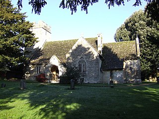
The Anglican Church of St Michael at Brimpsfield in the Cotswold District of Gloucestershire, England was built in 12th century. It is a grade I listed building.

Sezincote or Seasoncote is a settlement and civil parish comprising Sezincote House and its estate, situated about 3 miles from Stow-on-the-Wold in the Cotswold district of Gloucestershire, England. In 2001 the parish had a population of 90. The parish touches Bourton-on-the-Hill, Condicote, Cutsdean, Longborough and Moreton-in-Marsh. Sezincote has a parish meeting.


