Related Research Articles
Bristol is a city, unitary authority area and ceremonial county in South West England, the most populous city in the region. Built around the River Avon, it is bordered by the ceremonial counties of Gloucestershire to the north and Somerset to the south. The county is in the West of England combined authority area, which includes the Greater Bristol area and nearby places such as Bath.

Bristol Temple Meads is the oldest and largest railway station in Bristol, England. It is located 118 miles 31 chains away from London Paddington. It is an important transport hub for public transport in the city; there are bus services to many parts of the city and surrounding districts, with a ferry to the city centre. Bristol's other major station, Bristol Parkway, is a more recent station on the northern outskirts of the conurbation. It is the busiest station in South West England.

Avon was a non-metropolitan and ceremonial county in the west of England that existed between 1974 and 1996. The county was named after the River Avon, which flows through the area. It was formed from the county boroughs of Bristol and Bath, together with parts of the administrative counties of Gloucestershire and Somerset.

Backwell is a village and civil parish in the unitary authority of North Somerset and in 2011 had a population of 4,589. The village lies about 7 miles (11 km) southwest of Bristol, south of the A370 to Weston-super-Mare. The parish includes the hamlets of Backwell Common, Backwell Green, and Backwell Farleigh, and the districts of Backwell West Town and Downside.

Long Ashton is a village and civil parish in Somerset, England. It falls within the unitary authority of North Somerset and is one of a number of large villages just outside the boundary of city of Bristol urban area. The parish has a population of 6,044. The parish includes the hamlet of Yanley, and the residential area of Leigh Woods.

Ashton Court is a mansion house and estate to the west of Bristol in England. Although the estate lies mainly in North Somerset, it is owned by the City of Bristol. The mansion and stables are a Grade I listed building. Other structures on the estate are also listed.

Bristol Harbour is the harbour in the city of Bristol, England. The harbour covers an area of 70 acres. It is the former natural tidal river Avon through the city but was made into its current form in 1809 when the tide was prevented from going out permanently. A tidal by-pass was dug for 2 miles through the fields of Bedminster for the river, known as the "River Avon New Cut", "New Cut", or simply "The Cut". It is often called the Floating Harbour as the water level remains constant and it is not affected by the state of the tide on the river in the Avon Gorge, The New Cut or the natural river southeast of Temple Meads to its source.

Barrow Gurney is a village and civil parish in Somerset, England, situated in the unitary authority of North Somerset on the B3130, midway between the A38 and A370 near the Long Ashton bypass and Bristol Airport, 5 miles (8.0 km) south west of Bristol city centre. The civil parish includes Barrow Common, and has a population of 349.

Flax Bourton is a village and civil parish in Somerset, England. The parish, with a population of 715, is situated within the unitary authority of North Somerset, on the edge of Nailsea Moor on the A370 road 5 miles (8.0 km) south west of Bristol city centre.
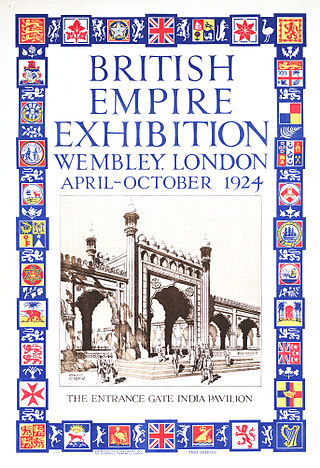
The British Empire Exhibition was a colonial exhibition held at Wembley Park, London England from 23 April to 1 November 1924 and from 9 May to 31 October 1925.

Bedminster, colloquially known as Bemmy, is a district of Bristol, England, on the south side of the city. It is also the name of a council ward which includes the central part of the district.
Brockley is a village and civil parish in Somerset, England. The parish is within the unitary authority of North Somerset, about 3 miles (4.8 km) south of Nailsea, and includes the village of Chelvey. According to the 2011 census it had a population of 277.

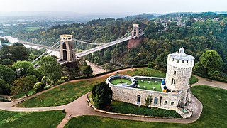
Leigh Woods is a 2-square-kilometre (0.77 sq mi) area of woodland on the south-west side of the Avon Gorge, close to the Clifton Suspension Bridge, within North Somerset opposite the English city of Bristol and north of the Ashton Court estate, of which it formed a part. Stokeleigh Camp, a hillfort thought to have been occupied from the third century BC to the first century AD and possibly also in the Middle Ages, lies within the reserve on the edge of the Nightingale Valley. On the bank of the Avon, within the reserve, are quarries for limestone and celestine which were worked in the 18th and 19th centuries are now derelict.

The Portishead Railway is a branch line railway running from Portishead in North Somerset to the main line immediately west of Bristol, England. It was constructed by the Bristol & Portishead Pier and Railway Company, but it was always operated by its main line neighbour, and was more usually thought of as the Portishead branch or the Portishead railway.

Bower Ashton is a village in south west Bristol on the western boundary with North Somerset, lying within the Southville ward, approximately two miles from the city centre. Ashton Court estate, a 850-acre (3.4 km2) recreational area owned by Bristol City Council lies just to the north, the Long Ashton by-pass to the south and the River Avon to the east.
The 1911 Festival of Empire was the biggest single event held at The Crystal Palace in London since its opening. It opened on 12 May and was one of the events to celebrate the coronation of King George V. The original intention had been that Edward VII would open it in 1910, however, this was postponed after his death shortly before the planned opening day. The Festival contained a display of landscapes and exhibits from the British Empire, mainly the dominion countries, to encourage emigration to those nations; and it contained a large scale pageant dramatising British history. It was described at the time as 'a social gathering of the British family' encouraging the 'firmer welding of those invisible bonds which hold together the greatest empire the world has ever known'. It has since been described as the 'ultimate imperialist propaganda showcase'.

Ashton Gate railway station was a railway station serving the Ashton Gate area of Bristol, England, which included Ashton Gate football ground, the home ground of Bristol City F.C. It was located on the Portishead Railway.

Clifton Bridge railway station is a former railway station in the Bower Ashton district of Bristol, England, near the River Avon. It was opened in 1867 by the Bristol and Portishead Pier and Railway Company as a single platform stop 3.4 miles (5.5 km) along the line from Bristol to Portishead. It was later taken over by the Great Western Railway and had a second platform added.

Pill railway station was a railway station on the Portishead Branch Line, 7.8 miles (12.6 km) west of Bristol Temple Meads, serving the village of Pill in North Somerset, England. The station was opened by the Bristol and Portishead Pier and Railway Company on 18 April 1867. It had two platforms, on either side of a passing loop, with a goods yard and signal box later additions. Services increased until the 1930s, at which point a half-hourly service operated. However the Portishead Branch was recommended for closure by the Beeching report, and the station was closed on 7 September 1964, although the line saw freight traffic until 1981. Regular freight trains through the station began to run again in 2002 when Royal Portbury Dock was connected to the rail network.
Shepherd's Bush is a neighbourhood in the London Borough of Hammersmith and Fulham centred on Shepherd's Bush Green. Originally a pasture for shepherds on their way to Smithfield market, it was largely developed in the late nineteenth and early twentieth centuries. In 1844 the West London Railway officially opened, followed in 1864 by the Metropolitan Railway who built the original Shepherd's Bush station, opening up the area to residential development. Businesses soon followed, and in 1903 the west side of Shepherd's Bush Green became the home of the Shepherd's Bush Empire, a music hall whose early performers included Charlie Chaplin.
References
- 1 2 Burlton 2014, pp. 10–11.
- ↑ Burlton 2014, pp. 14–17.
- ↑ Burlton 2014, p. 21.
- ↑ Burlton 2014, pp. 22–23.
- ↑ "International exhibition became known as a city". Bristol Post. 9 July 2013. Archived from the original on 1 February 2014. Retrieved 5 April 2016.
- ↑ Burlton 2014, p. 24.
- ↑ "Bristol's 'White City'". Bristol Record Office. Retrieved 5 April 2016.
- ↑ Burlton 2014, pp. 26–27.
- ↑ Burlton 2014, pp. 25–29.
- 1 2 Oakley 2006, pp. 57–60.
- ↑ "History of Bower Ashton". 2012. Archived from the original on 4 March 2016. Retrieved 4 November 2015.
- ↑ "Bristol's much heralded 'White City' which became a white elephant". Bristol Post. 14 October 2014. Retrieved 5 April 2016.[ permanent dead link ]
- ↑ Burlton 2014, pp. 28–36.
- ↑ Burlton 2014, pp. 38–39.
- ↑ "Bristol International Exhibition" . Western Mail. 26 May 1914. p. 6. Retrieved 7 April 2016.
- ↑ "Bristol International Exhibition" . Western Daily Press. 19 May 1914. p. 7. Retrieved 7 April 2016.
- ↑ Burlton 2014, pp. 36–39.
- ↑ Burlton 2014, pp. 39–49.
- ↑ Burlton 2014, pp. 49–52.
- ↑ "Bristol International Exhibition: A Progressive Policy" . Western Daily Press. 27 June 1914. p. 7. Retrieved 7 April 2016.
- ↑ "Bristol International Exhibition" . Western Daily Press. No. 7 July 1914. p. 12. Retrieved 7 April 2016.
- ↑ "Bristol International Exhibition 1914". Exhibition Study Group. Archived from the original on 8 January 2016. Retrieved 5 April 2016.
- ↑ Burlton 2014, pp. 52–57.
- ↑ "Bristol International Exhibition" . Western Daily Press. 1 July 1914. p. 5. Retrieved 7 April 2016.
- ↑ "Bristol International Exhibition" . Western Daily Press. 11 August 1914. p. 3. Retrieved 7 April 2016.
- ↑ "Ashton Gate Drill Hall". The Drill Hall Project. Retrieved 5 April 2016.
- ↑ Burlton 2014, pp. 60–90.
- ↑ Burlton 2014, pp. 92–95.
- ↑ "Original 'White City' built in last days of innocence". Western Daily Press. 19 August 2014. Retrieved 1 May 2016.[ permanent dead link ]