
The Old Red Sandstone is an assemblage of rocks in the North Atlantic region largely of Devonian age. It extends in the east across Great Britain, Ireland and Norway, and in the west along the northeastern seaboard of North America. It also extends northwards into Greenland and Svalbard. In Britain it is a lithostratigraphic unit to which stratigraphers accord supergroup status and which is of considerable importance to early paleontology. For convenience the short version of the term, ORS is often used in literature on the subject. The term was coined to distinguish the sequence from the younger New Red Sandstone which also occurs widely throughout Britain.

The geology of Great Britain is renowned for its diversity. As a result of its eventful geological history, Great Britain shows a rich variety of landscapes across the constituent countries of England, Wales and Scotland. Rocks of almost all geological ages are represented at outcrop, from the Archaean onwards.
The Lias Group or Lias is a lithostratigraphic unit found in a large area of western Europe, including the British Isles, the North Sea, the Low Countries and the north of Germany. It consists of marine limestones, shales, marls and clays.
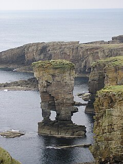
The Yesnaby Sandstone Group is a Devonian lithostratigraphic group in west Mainland Orkney, Scotland. The name is derived from the locality of Yesnaby where the strata are exposed in coastal cliffs.
The geology of Lancashire in northwest England consists in the main of Carboniferous age rocks but with Triassic sandstones and mudstones at or near the surface of the lowlands bordering the Irish Sea though these are largely obscured by Quaternary deposits.

The Norwich Crag Formation is a stratigraphic unit of the British Pleistocene Epoch. It is the second youngest unit of the Crag Group, a sequence of four geological formations spanning the Pliocene to Lower Pleistocene transition in East Anglia. It was deposited between approximately 2.4 and 1.8 million years ago, during the Gelasian Stage.
The Great Scar Limestone Group is a lithostratigraphical term referring to a succession of generally fossiliferous rock strata which occur in the Pennines in northern England and in the Isle of Man within the Tournaisian and Visean stages of the Carboniferous Period.
The geology of West Sussex in southeast England comprises a succession of sedimentary rocks of Cretaceous age overlain in the south by sediments of Palaeogene age. The sequence of strata from both periods consists of a variety of sandstones, mudstones, siltstones and limestones. These sediments were deposited within the Hampshire and Weald basins. Erosion subsequent to large scale but gentle folding associated with the Alpine Orogeny has resulted in the present outcrop pattern across the county, dominated by the north facing chalk scarp of the South Downs. The bedrock is overlain by a suite of Quaternary deposits of varied origin. Parts of both the bedrock and these superficial deposits have been worked for a variety of minerals for use in construction, industry and agriculture.
The Albion Glacigenic Group is a Quaternary lithostratigraphic group present in those parts of Great Britain which lie north of the southern limit of Anglian glaciation, but south of the Devensian glacial limit, and also includes deposits in the Isle of Man and offshore areas. It consists of a wide range of unconsolidated superficial deposits including till, sands, gravels, silts and clay of glacial, glaciofluvial, glaciolacustrine and glaciomarine origin. Its upper boundary is the present day ground surface or unconformable contact with units of the Caledonia Glacigenic Group, the Britannia Catchments Group or the British Coastal Deposits Group. It was previously known as the South Britain Glacigenic Group or Older Drift
The Caledonia Glacigenic Group is a Quaternary lithostratigraphic group present across the whole of Great Britain to the north and west of the furthest limit of Devensian glaciation ie throughout Scotland, Wales and northern England. It consists of a wide range of deposits deriving from the Devensian glaciation of glacial, glaciofluvial, glaciolacustrine and glaciomarine origin. It was previously known as the South Britain Glacigenic Group. Its upper boundary is the present day ground surface or an unconformable contact with the Britannia Catchments Group or the British Coastal Deposits Group.
The British Coastal Deposits Group is a Quaternary lithostratigraphic group present in coastal and estuarine areas around the margins of Great Britain. They are a mix of sands, gravels, silts, clays and peat and, north of a line between the Ribble and Tyne, include glacio-eustatically raised deposits. They lie unconformably on deposits of variously the Britannia Catchments Group, Albion Glacigenic Group, Caledonia Glacigenic Group, Dunwich Group, Crag Group or earlier bedrock. Their upper boundary is the present day ground surface.
The Dunwich Group is a Pleistocene lithostratigraphic group present in England north of the upper Thames and, downstream, a line drawn east from near Marlow to Clacton-on-Sea and which encompasses river terrace deposits of the Proto-Thames and other rivers. It unconformably overlies Triassic to Pleistocene bedrock and superficial deposits. In turn it is often overlain by deposits of the Albion Glacigenic Group and sometimes by those of the Britannia Catchments Group or British Coastal Deposits Group and interfingers in places with those of the Crag Group. No deposits potentially assignable to the group have been identified north of East Anglia or the English Midlands; they are likely to have been destroyed or removed by glacial action.
The Great Britain Superficial Deposits Supergroup is a Neogene to Quaternary lithostratigraphic supergroup present across Great Britain and the Isle of Man. It includes all of the natural superficial deposits found in Great Britain and comprises the Albion Glacigenic Group, Britannia Catchments Group, British Coastal Deposits Group, Caledonia Glacigenic Group, Crag Group, Dunwich Group and Residual Deposits Group. These deposits include till, sands, gravels, silts, head, clay, peat and other materials.
The Residual Deposits Group is a Palaeogene to Quaternary lithostratigraphic group present in those parts of southern and eastern England where the Chalk outcrops and in the Buchan district of northeast Scotland. In the former they consist of the 2 to 10 metres thick remanié deposit, Clay-with-Flints and in the latter the Buchan Gravels Formation which is up to 25 metres (82 ft) thick.
The geology of Northumberland in northeast England includes a mix of sedimentary, intrusive and extrusive igneous rocks from the Palaeozoic and Cenozoic eras. Devonian age volcanic rocks and a granite pluton form the Cheviot massif. The geology of the rest of the county is characterised largely by a thick sequence of sedimentary rocks of Carboniferous age. These are intruded by both Permian and Palaeogene dykes and sills and the whole is overlain by unconsolidated sediments from the last ice age and the post-glacial period. The Whin Sill makes a significant impact on Northumberland's character and the former working of the Northumberland Coalfield significantly influenced the development of the county's economy. The county's geology contributes to a series of significant landscape features around which the Northumberland National Park was designated.
The Arbuthnott-Garvock Group is a Devonian lithostratigraphic group in central Scotland. The name is derived from the village of Arbuthnott in Aberdeenshire and the Hill of Garvock near Laurencekirk. The group comprises the previously separate overlying Garvock Group and the underlying Arbuthnott Group.
This article describes the geology of the Broads, an area of East Anglia in eastern England characterised by rivers, marshes and shallow lakes (‘broads’). The Broads is designated as a protected landscape with ‘status equivalent to a national park’.
The geology of the Isle of Man consists primarily of a thick pile of sedimentary rocks dating from the Ordovician period, together with smaller areas of later sedimentary and extrusive igneous strata. The older strata was folded and faulted during the Caledonian and Acadian orogenies The bedrock is overlain by a range of glacial and post-glacial deposits. Igneous intrusions in the form of dykes and plutons are common, some associated with mineralisation which spawned a minor metal mining industry.
This article describes the geology of the Cairngorms National Park, an area in the Highlands of Scotland designated as a national park in 2003 and extended in 2010. The Cairngorms National Park extends across a much wider area than the Cairngorms massif itself and hence displays rather more varied geology.
