
The Gault Formation is a geological formation of stiff blue clay deposited in a calm, fairly deep-water marine environment during the Lower Cretaceous Period. It is well exposed in the coastal cliffs at Copt Point in Folkestone, Kent, England, where it overlays the Lower Greensand formation, and underlies the Upper Greensand Formation. These represent different facies, with the sandier parts probably being deposited close to the shore and the clay in quieter water further from the source of sediment; both are believed to be shallow-water deposits.
The Lias Group or Lias is a lithostratigraphic unit found in a large area of western Europe, including the British Isles, the North Sea, the Low Countries and the north of Germany. It consists of marine limestones, shales, marls and clays.

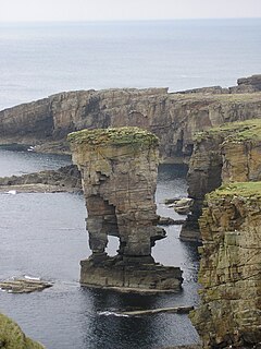
The Eday Group is a Devonian lithostratigraphic group in Orkney, northern Scotland. The name is derived from the island of Eday where the strata are exposed in coastal cliffs.
The Yesnaby Sandstone Group is a Devonian lithostratigraphic group in west Mainland Orkney, Scotland. The name is derived from the locality of Yesnaby where the strata are exposed in coastal cliffs.

The Sherwood Sandstone Group is a Triassic lithostratigraphic group which is widespread in Britain, especially in the English Midlands. The name is derived from Sherwood Forest in Nottinghamshire which is underlain by rocks of this age. It has economic importance as the reservoir of the Morecambe Bay gas field, the second largest gas field in the UK.
The Penarth Group is a Rhaetian age (Triassic) lithostratigraphic group which is widespread in Britain. It is named from the seaside town of Penarth near Cardiff in south Wales where strata of this age are exposed in coastal cliffs southwards to Lavernock Point. This sequence of rocks was previously known as the Rhaetic.
Haffield Breccia, or Clent Breccia, consist of a texturally immature compacted gravel, rich in volcanic clasts with some sedimentary rocks, in a sandy or muddy matrix, which outcrops in the English Midlands, in South Staffordshire, Birmingham and the Malverns. It is thought to have been deposited by during flash floods in rivers that were flowing through a desert, somewhere between 200 and 280 million years ago during the Permian period. The gravel consists of angular fragments, showing that they have not been transported over long distances.
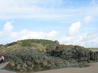
The Gwna Group is a late Precambrian (Ediacaran) / Cambrian lithostratigraphic group in northwest Wales. The name is derived from the Afon Gwna, a river near Bodorgan on Anglesey where the strata are exposed. This rock sequence is also commonly referred to as the Gwna Mélange.
The Heron Group is a Triassic lithostratigraphic group beneath the central and northern North Sea which is composed of alluvial deposits.

The Dent Group is a group of Upper Ordovician sedimentary and volcanic rocks in north-west England. It is the lowermost part of the Windermere Supergroup, which was deposited in the foreland basin formed during the collision between Laurentia and Avalonia. It lies unconformably on the Borrowdale Volcanic Group. This unit was previously known as the Coniston Limestone Group or Coniston Limestone Formation and should not be confused with the significantly younger Coniston Group.
The geology of West Sussex in southeast England comprises a succession of sedimentary rocks of Cretaceous age overlain in the south by sediments of Palaeogene age. The sequence of strata from both periods consists of a variety of sandstones, mudstones, siltstones and limestones. These sediments were deposited within the Hampshire and Weald basins. Erosion subsequent to large scale but gentle folding associated with the Alpine Orogeny has resulted in the present outcrop pattern across the county, dominated by the north facing chalk scarp of the South Downs. The bedrock is overlain by a suite of Quaternary deposits of varied origin. Parts of both the bedrock and these superficial deposits have been worked for a variety of minerals for use in construction, industry and agriculture.

The Exmoor Group is a late Devonian to early Carboniferous lithostratigraphic group in southwest England whose outcrop extends from Croyde in north Devon east across Exmoor to Minehead in west Somerset. The group comprises the following formations the:
The Albion Glacigenic Group is a Quaternary lithostratigraphic group present in those parts of Great Britain which lie north of the southern limit of Anglian glaciation, but south of the Devensian glacial limit, and also includes deposits in the Isle of Man and offshore areas. It consists of a wide range of unconsolidated superficial deposits including till, sands, gravels, silts and clay of glacial, glaciofluvial, glaciolacustrine and glaciomarine origin. Its upper boundary is the present day ground surface or unconformable contact with units of the Caledonia Glacigenic Group, the Britannia Catchments Group or the British Coastal Deposits Group. It was previously known as the South Britain Glacigenic Group or Older Drift
The Caledonia Glacigenic Group is a Quaternary lithostratigraphic group present across the whole of Great Britain to the north and west of the furthest limit of Devensian glaciation ie throughout Scotland, Wales and northern England. It consists of a wide range of deposits deriving from the Devensian glaciation of glacial, glaciofluvial, glaciolacustrine and glaciomarine origin. It was previously known as the South Britain Glacigenic Group. Its upper boundary is the present day ground surface or an unconformable contact with the Britannia Catchments Group or the British Coastal Deposits Group.
The Britannia Catchments Group is a Quaternary lithostratigraphic group present in all parts of Great Britain and including the Isle of Man. It includes a wide range of deposits including alluvium, river terrace deposits, peat, head, cover sand and blown sand of fluvial, lacustrine, mass movement, periglacial and aeolian origin. Its lower boundary is defined as an unconformable contact with the underlying Albion Glacigenic Group, the Caledonia Glacigenic Group, the Dunwich Group, Crag Group or with older bedrock. Its upper boundary is generally the present day ground surface but it interfingers locally with the British Coastal Deposits Group.
The Dunwich Group is a Pleistocene lithostratigraphic group present in England north of the upper Thames and, downstream, a line drawn east from near Marlow to Clacton-on-Sea and which encompasses river terrace deposits of the Proto-Thames and other rivers. It unconformably overlies Triassic to Pleistocene bedrock and superficial deposits. In turn it is often overlain by deposits of the Albion Glacigenic Group and sometimes by those of the Britannia Catchments Group or British Coastal Deposits Group and interfingers in places with those of the Crag Group. No deposits potentially assignable to the group have been identified north of East Anglia or the English Midlands; they are likely to have been destroyed or removed by glacial action.
The Great Britain Superficial Deposits Supergroup is a Neogene to Quaternary lithostratigraphic supergroup present across Great Britain and the Isle of Man. It includes all of the natural superficial deposits found in Great Britain and comprises the Albion Glacigenic Group, Britannia Catchments Group, British Coastal Deposits Group, Caledonia Glacigenic Group, Crag Group, Dunwich Group and Residual Deposits Group. These deposits include till, sands, gravels, silts, head, clay, peat and other materials.
The geology of Northumberland in northeast England includes a mix of sedimentary, intrusive and extrusive igneous rocks from the Palaeozoic and Cenozoic eras. Devonian age volcanic rocks and a granite pluton form the Cheviot massif. The geology of the rest of the county is characterised largely by a thick sequence of sedimentary rocks of Carboniferous age. These are intruded by both Permian and Palaeogene dykes and sills and the whole is overlain by unconsolidated sediments from the last ice age and the post-glacial period. The Whin Sill makes a significant impact on Northumberland's character and the former working of the Northumberland Coalfield significantly influenced the development of the county's economy. The county's geology contributes to a series of significant landscape features around which the Northumberland National Park was designated.
This article describes the geology of the Broads, an area of East Anglia in eastern England characterised by rivers, marshes and shallow lakes (‘broads’). The Broads is designated as a protected landscape with ‘status equivalent to a national park’.
