Related Research Articles

Alaska is a non-contiguous U.S. state on the northwest extremity of North America. It is in the Western United States region. The only other non-contiguous U.S. state is Hawaii. Alaska is also considered to be the northernmost, westernmost, and easternmost state in the United States. It borders the Canadian territory of Yukon and the province of British Columbia to the east. It shares a western maritime border, in the Bering Strait, with Russia's Chukotka Autonomous Okrug. The Chukchi and Beaufort Seas of the Arctic Ocean lie to the north, and the Pacific Ocean lies to the south. Technically, it is a semi-exclave of the U.S., and is the largest exclave in the world.

Fairbanks is a home rule city and the borough seat of the Fairbanks North Star Borough, Alaska, United States. Fairbanks is the largest city in the Interior region of Alaska and the second largest in the state. The 2020 Census put the population of the city proper at 32,515 and the population of the Fairbanks North Star Borough at 95,655, making it the second most populous metropolitan area in Alaska after Anchorage. The Metropolitan Statistical Area encompasses all of the Fairbanks North Star Borough and is the northernmost Metropolitan Statistical Area in the United States, located 196 miles by road south of the Arctic Circle.

Delta Junction, officially the City of Delta Junction, is a small city in the Southeast Fairbanks Census Area, Alaska, United States. As of the 2010 census, the population was 958, up from 840 in 2000. The 2018 estimate was down to 931. The city is located a short distance south of the confluence of the Delta River with the Tanana River, which is at Big Delta. It is about 160 km (99 mi) south of Fairbanks. Native inhabitants are Tanana Athabaskans.

Tok is a census-designated place (CDP) in Southeast Fairbanks Census Area, Alaska, United States. The population was 1,243 at the 2020 census, slightly down from 1,258 in 2010.

Nenana (Lower Tanana: Toghotili; is a home rule city in the Yukon-Koyukuk Census Area of the Unorganized Borough in Interior Alaska. Nenana developed as a Lower Tanana community at the confluence where the tributary Nenana River enters the Tanana. The population was 378 at the 2010 census, down from 402 in 2000.

The Alaska Range is a relatively narrow, 600-mile-long (950 km) mountain range in the southcentral region of the U.S. state of Alaska, from Lake Clark at its southwest end to the White River in Canada's Yukon Territory in the southeast. Denali, the highest mountain in North America, is in the Alaska Range. The range is part of the American Cordillera.

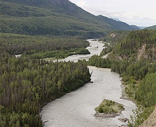
The Susitna River is a 313-mile (504 km) long river in the Southcentral Alaska. It is the 15th largest river in the United States, ranked by average discharge volume at its mouth. The river stretches from the Susitna Glacier to Cook Inlet's Knik Arm.

The Nenana River is a tributary of the Tanana River, approximately 140 miles (230 km) long, in central Alaska in the United States. It drains an area on the north slope of the Alaska Range on the south edge of the Tanana Valley southwest of Fairbanks.
The Matanuska River (Dena'ina: Ch'atanhtnu; Ahtna: Ts'itonhna’) is a 75-mile (121 km) long river in Southcentral Alaska, United States. The river drains a broad valley south of the Alaska Range eponymously known as the Matanuska Valley.

The George Parks Highway, usually called simply the Parks Highway, runs 323 miles (520 km) from the Glenn Highway 35 miles (56 km) north of Anchorage to Fairbanks in the Alaska Interior. The highway, originally known as the Anchorage-Fairbanks Highway, was completed in 1971, and given its current name in 1975.

The Alaska Railroad is a Class II railroad that operates freight and passenger trains in the state of Alaska. The railroad's mainline runs between Seward on the southern coast and Fairbanks, near the center of the state. It passes through Anchorage and Denali National Park, to which 17% of visitors travel by train.

The Seward Highway is a highway in the U.S. state of Alaska that extends 125 miles (201 km) from Seward to Anchorage. It was completed in 1951 and runs through the scenic Kenai Peninsula, Chugach National Forest, Turnagain Arm, and Kenai Mountains. The Seward Highway is numbered Alaska Route 9 (AK-9) for the first 37 miles (60 km) from Seward to the Sterling Highway and AK-1 for the remaining distance to Anchorage. At the junction with the Sterling Highway, AK-1 turns west towards Sterling and Homer. About eight miles (13 km) of the Seward Highway leading into Anchorage is built to freeway standards. In Anchorage, the Seward Highway terminates at an intersection with 5th Avenue, which AK-1 is routed to, and which then leads to the Glenn Highway freeway.

The Port of Alaska (POA) is a deep-water port in Anchorage, Alaska, with three bulk carrier berths, two petroleum berths, and one barge berth. The name was changed from "Port of Anchorage" to the "Port of Alaska" in 2017. It is an enterprise department of the Municipality of Anchorage. It is distinguished from other types of municipal departments largely because it generates enough revenue to support its operations without being a burden to Anchorage property tax payers, and it also pays a fee-in-lieu of taxes to help run city government.
This article discusses transportation in the U.S. state of Alaska.
Anchorage, officially the Municipality of Anchorage, is the most populous city in the U.S. state of Alaska. With a population of 291,247 at the 2020 census, it contains nearly 40 percent of the state's population. The Anchorage metropolitan area, which includes Anchorage and the neighboring Matanuska-Susitna Borough, had a population of 398,328 in 2020, accounting for more than half the state's population. At 1,706 sq mi (4,420 km2) of land area, the city is the fourth-largest by area in the U.S.

Chatanika is a small unincorporated community located in the Fairbanks North Star Borough, Alaska, United States, north-northeast of the city of Fairbanks. The community runs along an approximately 20-mile (32 km) stretch of the Steese Highway, the majority of which sees the highway paralleled by the Chatanika River. The community consists of sparsely scattered residential subdivisions, several roadside businesses, a boat launch where the Steese Highway crosses the Chatanika River, relics of past gold mining operations in the area and the Poker Flat Research Range operated by the Geophysical Institute of the University of Alaska Fairbanks.

Isabel Pass is a 40 mile long gap in the eastern section of the Alaska Range which serves as a corridor for the Richardson Highway about 11 miles from Paxson. It is named after Isabelle Barnette, the wife of E. T. Barnette, who helped found Fairbanks. The pass separates four regions, the Tanana Valley to the north, the Delta Mountains to the east, Copper River Basin to the south, and the Hayes Range to the west.
The Minnesota Drive Expressway is a 7.560-mile-long (12.167 km) south–north expressway located in the city of Anchorage, Alaska, United States. The expressway includes a small portion of O'Malley Road, which is also built to expressway standards. The highway travels from the southern region of Anchorage northward to North Star neighborhood area, and bisects the community of Spenard. The first section of the highway was constructed around 1950, and the entire highway was upgraded to expressway standards by the year of 1985. The entire length of the expressway is listed on the National Highway System, a network of roads important to the country's economy, defense, and mobility.

The Chulitna River (Dena'ina: Ts'ilutnu) is a 110 km long right tributary of the Susitna River in southern part of interior Alaska. Three forks converge to form the river, which itself flows into the Susitna River near Talkeetna.
The 1967 Tanana Valley Flood or 1967 Fairbanks Flood was a severe flood that affected east-central Alaska in August of 1967. The city of Fairbanks, nearby Fort Wainwright, and Nenana saw record breaking water levels and widespread damage. Flooding was recorded over a large swath of the state, from Eagle on the east to Ruby on the west. Many major tributaries to the Yukon River saw flooding, including the Salcha, Chatanika, Tolovana, lower Tanana, and Birch Creek rivers. The worst flooding occurred in the White Mountains northeast of Fairbanks, although this area is sparsely populated.
References
- 1 2 "Broad Pass". Geographic Names Information System . United States Geological Survey, United States Department of the Interior.
- ↑ Cross, Whitman. Memoir of George H. Eldridge (PDF). Geological Society of America.
- ↑ Fred H. Moffit (1916). Broad Pass Region, Alaska (PDF) (Report). United States Geological Survey.
- ↑ "Alaska Railroad". History. Retrieved 21 March 2024.
- ↑ "Alaska Department of Transportation". Parks Highway. Retrieved 21 March 2024.
| | This Alaska-related article is a stub. You can help Wikipedia by expanding it. |