Bromley Palace

Last updated

Bromley Palace
South Face of Bromley Palace (02).jpg
The south face of Bromley Palace
Location Bromley, England
Coordinates 51°24′12″N0°01′17″E / 51.4034°N 0.0215°E / 51.4034; 0.0215
Built1100
Listed Building – Grade II
Designated10 January 1955
Reference no.1281268
Bromley London UK location map.svg
Red pog.svg
Shown in Bromley

Bromley Palace (also known as the Bishop's Palace) is a manor house at Bromley in the London Borough of Bromley. It was the bishop's palace of the Bishops of Rochester from the 12th century to 1845. The building, which is now part of Bromley Civic Centre, is a Grade II listed building. [1]

Contents

History of the site

Bromley Palace, 19th century Bromley Palace.PNG
Bromley Palace, 19th century

In the 8th century, King Æthelbert II of Kent granted 6 "sulings" [2] of land, which came to be known as the Manor of Bromley, to Eardwulf, Bishop of Rochester. [3] In 862 Æthelberht III, king of Wessex and Kent, granted 10 sulings in Bromley to his minister Dryhtwald. [4] In 967, King Edgar I of England again granted 10 sulings of land to Bishop Ælfstan in return for a large sum in gold and silver. [5]

In the year 987, a dispute between King Ethelred II and the Bishop of Rochester led to the land being seized and given to one of the king's ministers (Æthelsine) though a royal act of contrition led to its return in 998. [6] After the conquest, another expropriation was attempted by Bishop Odo of Bayeux (half-brother of William the Conqueror himself) and Archbishop Lanfranc (of Canterbury) had to intervene to restore the land to the diocese. [7] [8]

The Manor of Bromley was described as "poor....neither pasture nor arable land being worth much". [9] It is thought that a manor house was first built here around the year 1100. One source claims that the architect was Bishop Gundulph but this seems unlikely because he had a reputation for commissioning buildings of "massive and enduring character" and records show that Bromley Palace had fallen into dilapidation by the time of Bishop Waleran, who died in 1184. [10] As a result, Waleran's successor, Gilbert de Glanville, ordered the manor house to be rebuilt – "in a more commodious manner". A historian had this to say about the original manor house:

The first house and gardens probably did not cover a larger space than two acres, and were surrounded by a moat. The masonry supporting the ancient drawbridge, the remains of which consisted of a rude mass of flint and chalk, cemented together by mortar which had become as hard as stone, was discovered....about forty-five yards north of the present house; and....to the south....foundation walls, the lower portions of which were constructed of blocks of chalk. [11]

The grounds of the palace contained a Holy Well and Oratory dedicated to Saint Blaise and the site became a place of pilgrimage for centuries. [12]

The pulhamite waterfall in the grounds of the palace, now Grade II listed Pulhamite Waterfall in Bromley Palace Park (01).jpg
The pulhamite waterfall in the grounds of the palace, now Grade II listed

In 1648, during the English Civil War – and due to an Act of Parliament which ordered the disposal of certain church property – the manor of Bromley was sold to Augustine Skinner. [13] The manor house was again returned to the Diocese of Rochester (and its rightful incumbent, Bishop John Warner) in 1660, on the restoration of Charles II. [14]

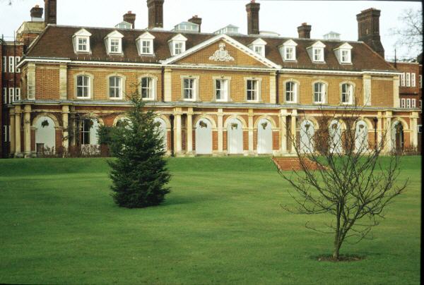
In 1669, Bishop Sprat had the existing chapel (which was "wainscotted eight foote high with oake") pulled down and rebuilt (the new chapel was consecrated in 1701), and improvements were made to the grounds of the palace. Further additions and improvements were made to the manor by Bishops Francis Atterbury (served 1713–1723) and Joseph Wilcocks (served 1731–1756). But by 1774 the palace had fallen into disrepair and Bishop John Thomas ordered it to be pulled down and rebuilt – see illustration. [15] [16]

In 1845 the palace passed out of the hands of the Bishops of Rochester when it was sold to Coles Child, a wealthy local businessman. [1] He had the house remodelled in 1863 (reputedly by Richard Norman Shaw) and 1903/1920s (reputedly by Ernest Newton). [17]

The 107th edition of Burkes Peerage, (2003), states the Coles were Lords of the Manor of Bromley, and lived in the Palace. The actor Sir Coles John Jeremy Child, (1944-2022), was a member of the family. [18]

The ice house in the grounds of the palace park, now Grade II listed The Ice House at Bromley Palace Park (01).jpg
The ice house in the grounds of the palace park, now Grade II listed

In the 1920s it became a girls' finishing school and in 1935 Stockwell College of Education, a teacher training college when extensions were added. During the Second World War (from 1940 to 1945) members of the Stockwell College of Education were temporarily relocated to Watcombe Park, Devon. While the Stockwell College were away, the Bishop's Otter College, Chichester whose own buildings were requisitioned by the Air Ministry, temporarily moved into Bromley Palace until 1944. [19] [20]

More extensions were added in 1960 when Kent County Council – then the county authority - took control. It became a grade II listed building in 1973. [1] The college closed in 1980 and, as part of a wider regeneration scheme to create a new Civic Centre, the London Borough of Bromley moved their headquarters from the town hall to the palace in 1982. [21]

The faux-medieval folly in the palace grounds, now Grade II listed Folly at Bromley Palace Park (01).jpg
The faux-medieval folly in the palace grounds, now Grade II listed

A small area of the original parkland survives immediately around the palace. It comprises lawns, a lake, belts of mature trees, a boat house, pulhamite rockeries, an ice house (building) and a folly. [22]

See also

Related Research Articles

<span class="mw-page-title-main">Beckenham</span> Human settlement in England

Beckenham is a town in Greater London, England, within the London Borough of Bromley. Until 1965 it was part of the historic county of Kent. It is located 8.4 miles (13.5 km) south-east of Charing Cross, situated north of Elmers End and Eden Park, east of Penge, south of Lower Sydenham and Bellingham, and west of Bromley and Shortlands. Its population at the 2011 census counted 46,844 inhabitants.

<span class="mw-page-title-main">Mottingham</span> Area of south-east London

Mottingham is a district of south-east London, England, which straddles the border of both the London Borough of Bromley and the Royal Borough of Greenwich. It is located south west of Eltham Town Centre, 1.5 miles. It was historically within the county of Kent.

<span class="mw-page-title-main">Plumstead</span> Human settlement in England

Plumstead is an area in southeast London, within the Royal Borough of Greenwich, England. It is located east of Woolwich.

<span class="mw-page-title-main">Greenwich</span> Town in south-east London, England

Greenwich is a town in south-east London, England, within the ceremonial county of Greater London. It is situated 5.5 miles (8.9 km) east-southeast of Charing Cross.

<span class="mw-page-title-main">Thomas Sprat</span> English churchman and writer (1635–1713)

Thomas Sprat, FRS was an English churchman and writer, Bishop of Rochester from 1684.

<span class="mw-page-title-main">Bromley</span> Area of south east London

Bromley is a large town in Greater London, England, within the London Borough of Bromley. It is 9+12 miles southeast of Charing Cross, and had an estimated population of 88,000 as of 2023.

<span class="mw-page-title-main">Strood</span> Town in Medway in South East England

Strood is a town in the unitary authority of Medway in Kent, South East England. The town forms a conurbation with neighbouring towns Chatham, Rochester, Gillingham and Rainham. It lies on the northwest bank of the River Medway at its lowest bridging point.

Edward Hasted was an English antiquarian and pioneering historian of his ancestral home county of Kent. As such, he was the author of a major county history, The History and Topographical Survey of the County of Kent (1778–99).

<span class="mw-page-title-main">Bobbing, Kent</span> Human settlement in England

Bobbing is a village and civil parish in the Swale district of Kent, England, about a mile north-west of Sittingbourne, and forming part of its urban area. The hamlet of Howt Green and village of Keycol are included within the parish. According to the 2011 census Bobbing parish had a population of 1,969.

<span class="mw-page-title-main">Cliffe Woods</span> Human settlement in England

Cliffe Woods is a small estate on the Hoo Peninsula in the unitary authority of Medway in South East England. It was, until 1998, part of Kent and is still ceremonially associated via the Lieutenancies Act. It forms part of the parish of Cliffe and Cliffe Woods.

<span class="mw-page-title-main">Halling, Kent</span> Human settlement in England

Halling is a village on the North Downs in the northern part of Kent, England. Consisting of Lower Halling, Upper Halling and North Halling, it is scattered over some 3 miles (5 km) along the River Medway parallel to the Pilgrims' Way which runs through Kent.

<span class="mw-page-title-main">Ospringe</span> Human settlement in England

Ospringe is a village and area of Faversham in the English county of Kent. It is also the name of a civil parish, which since 1935 has not included the village of Ospringe.

<span class="mw-page-title-main">St. Blaise's Well</span>

St Blaise's Well is a holy well located in the grounds of the old Bishop's Palace, now part of Bromley Civic Centre in Bromley, London.

Sir Thomas Browne was a Member of Parliament and Chancellor of the Exchequer. Browne's tenure as Chancellor occurred during the Great Bullion Famine and the Great Slump in England. He was executed for treason on 20 July 1460.

Simpson's Manor, or Simpson's Place, was a moated medieval manor house in Bromley, Kent, England, with evidence of habitation going back to the reign of Edward I. It was demolished around 1870 but survives in the name of a (minor) local road – Simpson's Place.

<span class="mw-page-title-main">All Saints Church, Frindsbury</span> Church in Kent , England

All Saints, Frindsbury, is a parish church serving the combined parish of Frindsbury with Upnor and Chattenden. The church dates from 1075 and lies in the north-west corner of the Medway Towns, historically part of Kent, England. It is a Grade II* listed building, National Heritage List number 1107886.

<span class="mw-page-title-main">Norton, Buckland and Stone</span> Human settlement in England

Norton, Buckland and Stone is a small rural civil parish 1 mile (1.6 km) east of Teynham and 3 miles (4.8 km) west of the centre of Faversham in the borough of Swale, Kent, England. It is bypassed by the M2 to the south and traverses the historic A2, on the route of the Roman road of Watling Street.

<span class="mw-page-title-main">Well Hall</span> Human settlement in England

Well Hall is a place to the north of Eltham in the Royal Borough of Greenwich in southeast London, England, with no present formal boundaries and located 13.5 km (8.4 mi) east-southeast of Charing Cross. In the past Well Hall was the grounds of a manor house, and then a hamlet. Today it is a largely residential suburb and housing estate absorbed by the development of Eltham and London. It is centred on the main road between Eltham and Woolwich, on which many shops and businesses are located. Several major A roads including the South Circular Road and A2 road pass through the area, as does a railway line, serving Eltham station which is located in Well Hall. The Postcode that covers Well Hall and most of the Eltham area is SE9, and the 020 dialing covers the entire Royal Borough of Greenwich. Well Hall is split across two electoral wards, Eltham West on the west side of Well Hall Road, and Eltham North on the east side of Well Hall Road. In 2015 the population of these two wards combined was recorded as 24,621, although the wards cover a larger area than just Well Hall.

Stockwell College of Education was a teacher-training college based in South London, England. It was located in Stockwell, South London from 1860 to 1935 and then relocated to the grounds of Bromley Palace, Bromley until its closure in 1980.

<span class="mw-page-title-main">St Botolph's Church, Ruxley</span> Church in London Borough of Bromley, United Kingdom

St Botolph's Church is a church building in Ruxley, in the London Borough of Bromley, southeast London, England. It was constructed in the thirteenth century and dedicted to Botwulf of Thorney. St Botolph's was used as a church for around 300 years but was deconsecrated in 1557. The church was then used a farm building for over 400 years and the remains of an oast house are still adjacent to it. In the 1960s archaeological work was carried out on the site and found evidence of an older wooden building, suggesting there may have been an older Saxon church in the same location. Today the church is a Grade II listed building and a scheduled ancient monument on the grounds of Ruxley Manor Garden Centre, although many features are still intact, the church is in disrepair and English Heritage have agreed to pay a grant to help preserve the building.

References

  1. 1 2 3 Historic England. "The Old Palace, Bromley (1281268)". National Heritage List for England . Retrieved 26 April 2020.
  2. Clinch (quoting Lysons) records that, in parts of the Domesday Book, a suling (aka sulin, or sowling) is described as an area of land of about 220 acres.
  3. Hasted records that the grant was listed in an apograph in Dering library (at Surrenden manor nr. Pluckley, Kent – owned by Sir Edward Dering). Lysons confirms this grant as occurring in the 8th century while Dunkin records the grant as "6 furlongs". However no charter can be found online to confirm this grant (as at Apr 2010).
  4. Anglosaxon charter s331 Archived July 20, 2007, at the Wayback Machine .
  5. Hasted, Edward. The History and Topographical Survey of the County of Kent: Volume 1, 550–570
  6. Clinch, George. Antiquarian Jottings, pp 5–6.
  7. Clinch, George. p6.
  8. See also the "Trial of Penenden Heath" – the inquiry ordered into the activity Of Bishop Odo by William I.
  9. Clinch, George. p7.
  10. Clinch, George. pp 10–11)
  11. "The Church and Manor of Bromley", a research paper by Dr W. T. Beeby (from Clinch. Antiquarian Jottings, p11).
  12. Williams, Barrie. St Blaise's Well, Bromley, Kent. The Holy Wells Journal, Issue 6 - Summer 1998. Archived from the original on 6 October 2006. Retrieved 26 April 2020.
  13. See List of Parliamentray ordinances – Oct 1646.
  14. Clinch, George. p10.
  15. Clinch, George. pp11-12.
  16. Hasted's "History of kent" [vol. i. p, 90] contains a large engraving of the old Bishop's Palace as it was before the year 1756.
  17. "Ernest Newton". Chislehurst Society. Retrieved 26 April 2020.
  18. Burke's Peerage, Baronetage and Knightage, 107th ed., vol. 1, ed. Charles Mosley, Burke's Peerage Ltd, 2003, p. 776
  19. "Bishop Otter College". University of Chichester. Archived from the original on 14 August 2023. Retrieved 14 September 2023.
  20. Edwards, Elizabeth, Women in Teacher Training Colleges, 1900-1960, London: Routledge, pp. 58–61, ISBN   0-415-21476-9
  21. "A Bromley walk". London Footprints. Retrieved 26 April 2020.
  22. Historic England. "Victorian Folly of 'Medieval Ruins' in Bromley Palace Park, Rafford Way - Bromley (1186785)". National Heritage List for England . Retrieved 26 April 2020.

Further reading