Bronx Park East station

Last updated

 Bronx Park East
  NYCS-bull-trans-2-Std.svg NYCS-bull-trans-5-Std.svg
MTA NYC logo.svg New York City Subway station (rapid transit)
Bronx Pk East IRTWP SB plat jeh.jpg
Southbound platform
Station statistics
AddressBirchall Avenue & Sagamore Street
Bronx, NY 10462
Borough The Bronx
Locale Van Nest/Pelham Parkway
Coordinates 40°50′56″N73°52′05″W / 40.849°N 73.868°W / 40.849; -73.868
Division [1]
Line IRT White Plains Road Line
Services    2   NYCS-SSI-alltimes.svg (all times)
   5   NYCS-SSI-rushpeak.svg (limited weekday rush hour service in the peak direction)
TransitAiga bus trans.svg NYCT Bus: Bx22, Bx39
Structure Elevated
Platforms2 side platforms
Tracks3
Other information
OpenedMarch 3, 1917;107 years ago (1917-03-03)
Opposite-
direction
transfer
Yes
Traffic
2022470,109 [2] Increase2.svg 11.5%
Rank387 out of 423 [2]
Services
Preceding station MTA NYC logo.svg New York City Subway Following station
Pelham Parkway
2   NYCS-SSI-alltimes.svg 5   NYCS-SSI-rushpeak.svg
NYCS-bull-trans-2-Std.svg
Local
East 180th Street
2   NYCS-SSI-alltimes.svg 5   NYCS-SSI-rushpeak.svg
Location
NYCS map blank.svg
Map pointer.svg
USA New York City location map.svg
Map pointer.svg
USA New York location map.svg
Map pointer.svg
Track layout

Contents

BSicon dMFADEg.svg
BSicon udSTR.svg
BSicon dMFADEg.svg
BSicon udSTR.svg
BSicon dMFADEg.svg
BSicon udSTR.svg
BSicon udSTRf.svg
BSicon udSTR.svg
BSicon udSTRg.svg
BSicon PLTl.svg
BSicon udSTR.svg
BSicon udSTR.svg
BSicon udSTR.svg
BSicon PLTr.svg
BSicon PLTl.svg
BSicon udSTR.svg
BSicon udSTR.svg
BSicon udSTR.svg
BSicon PLTr.svg
BSicon numN330.svg
BSicon PLTl.svg
BSicon udSTR.svg
BSicon udSTR.svg
BSicon udSTR.svg
BSicon PLTr.svg
BSicon PLTl.svg
BSicon udSTR.svg
BSicon udSTR.svg
BSicon udSTR.svg
BSicon PLTr.svg
BSicon uvUSTr.svg
BSicon udSTR.svg
BSicon udSTRc2.svg
BSicon uv-ABZg3.svg
BSicon udSTR.svg
BSicon udSTR.svg
BSicon dMFADEf.svg
BSicon udSTR+1.svg
BSicon udSTRc4.svg
BSicon udSTRf.svg
BSicon udSTR.svg
BSicon udSTRg.svg
BSicon dMFADEf.svg
BSicon udSTR.svg
BSicon dMFADEf.svg
BSicon udSTR.svg
BSicon dMFADEf.svg
BSicon udSTR.svg
Street map

Bronx Park East station

Station service legend
SymbolDescription
NYCS-SSI-alltimes.svg Stops all times
NYCS-SSI-rushpeak.svg Stops rush hours in the peak direction only

The Bronx Park East station is a local station on the IRT White Plains Road Line of the New York City Subway. Located in the Bronx on Birchall Avenue at Sagamore Street, it is served by the 2 train at all times and by the 5 train during rush hours in the peak direction.

History

This station was built under the Dual Contracts. It opened on March 3, 1917, as part of an extension of the IRT White Plains Road Line from East 177th Street–East Tremont Avenue to East 219th Street–White Plains Road, providing the Bronx communities of Williamsbridge and Wakefield with access to rapid transit service. Service on the new portion of the line was operated as a four-car shuttle from 177th Street due to the power conditions at the time. [3] [4] [5] The city government took over the IRT's operations on June 12, 1940. [6] [7]

It was renovated in 2007 at a cost of $12.92 million. [8]

Station layout

Platform level Side platform
Northbound local NYCS-bull-trans-2-Std.svg toward Wakefield–241st Street (Pelham Parkway)
NYCS-bull-trans-5-Std.svg PM rush toward Nereid Avenue (Pelham Parkway)
Peak-direction express NYCS-bull-trans-5-Std.svg does not stop here (select AM rush hour trips)
Southbound local NYCS-bull-trans-2-Std.svg toward Flatbush Avenue–Brooklyn College via Seventh (East 180th Street)
NYCS-bull-trans-5-Std.svg AM rush toward Flatbush Avenue–Brooklyn College via Lexington (East 180th Street)
Side platform
MezzanineFare control, station agent, MetroCard machines
GroundStreet levelEntrances/exits

This elevated station has three tracks and two side platforms. [9] Old signs at the center exit stairs and have been painted over, but those on the southbound platform are still visible through the paint. Covered windows in the concrete wall are also present.[ citation needed ]

This station and the Pelham Parkway station are the only stations on the White Plains Road Line to be built in decorative concrete structures. The entrances at this station were built in this manner as Sagamore Street was the new main entrance to Bronx Park. [10]

South of this station, one can view the IRT Dyre Avenue Line just off to the east. Continuing south, the Unionport Yard is also to the east past the connection to the Dyre Avenue Line. The East 180th Street Yard is to the west just prior to entering the next station, East 180th Street. [9]

The 2006 artwork here is called B is for Birds in the Bronx by Candida Alvarez. [11] [12]

Exits

The tiled mezzanine has windows and standard "Uptown" and "Downtown" mosaics. The mezzanine itself is made of stucco over concrete and is massive. There are exits to all corners of Birchell Avenue and Sagamore Street except for the southwest corner, which had its exit sealed for unknown reasons. [13]

Related Research Articles

<span class="mw-page-title-main">2 (New York City Subway service)</span> New York City Subway service

The 2 Seventh Avenue Express is a rapid transit service in the A Division of the New York City Subway. Its route emblem, or "bullet", is colored red since it uses the IRT Broadway–Seventh Avenue Line through most of Manhattan.

<span class="mw-page-title-main">Whitlock Avenue station</span> New York City Subway station in the Bronx

The Whitlock Avenue station is a local station on the IRT Pelham Line of the New York City Subway. It is served by the 6 train at all times and is located at Whitlock Avenue and Westchester Avenue in the Bronx.

<span class="mw-page-title-main">West Farms Square–East Tremont Avenue station</span> New York City Subway station in the Bronx

The West Farms Square–East Tremont Avenue station is a local station on the IRT White Plains Road Line of the New York City Subway. Located at the intersection of East Tremont Avenue and Boston Road in the West Farms neighborhood of the Bronx, it is served by the 2 train at all times, and the 5 train at all times except late nights and rush hours in the peak direction.

<span class="mw-page-title-main">East 180th Street station</span> New York City Subway station in the Bronx

The East 180th Street station is an elevated express station on the IRT White Plains Road Line of the New York City Subway. Located at the intersection of East 180th Street and Morris Park Avenue in the Bronx, it is served by the 2 and 5 trains at all times.

<span class="mw-page-title-main">Pelham Parkway station (IRT White Plains Road Line)</span> New York City Subway station in the Bronx

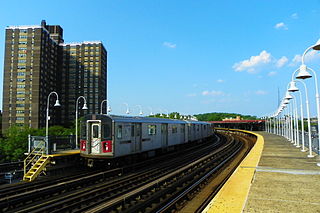
The Pelham Parkway station is a local station on the IRT White Plains Road Line of the New York City Subway. Located in the Bronx at the intersection of Pelham Parkway and White Plains Road, it is served by the 2 train at all times and by the 5 train during rush hours in the peak direction.

<span class="mw-page-title-main">Gun Hill Road station (IRT White Plains Road Line)</span> New York City Subway station in the Bronx

The Gun Hill Road station is an express station on the IRT White Plains Road Line of the New York City Subway. Located in the Bronx at the intersection of Gun Hill and White Plains Roads, it is served by the 2 train at all times and by the 5 train during rush hours in the peak direction; limited a.m. rush hour 5 trains from Manhattan also terminate at this station in the northbound direction only.

The IRT Dyre Avenue Line is a New York City Subway rapid transit line, part of the A Division. It is a branch of the IRT White Plains Road Line in the northeastern section of the Bronx, north of East 180th Street. As of 2013, it has a daily ridership of 34,802.

<span class="mw-page-title-main">IRT White Plains Road Line</span> New York City Subway line

The White Plains Road Line is a rapid transit line of the A Division of the New York City Subway serving the central Bronx. It is mostly elevated and served both subway and elevated trains until 1952. The original part of the line, the part opened as part of the first subway was called the West Farms Division, and the extension north to 241st Street as part of the Dual Contracts was called the White Plains Road Line. Eventually, however, the two parts came to be known as the White Plains Road Line.

<span class="mw-page-title-main">Wakefield–241st Street station</span> New York City Subway station in the Bronx

The Wakefield–241st Street station is a terminal station on the IRT White Plains Road Line of the New York City Subway, located at the intersection of 241st Street and White Plains Road in the Wakefield neighborhood of the Bronx. It is served by the 2 train at all times. This station is geographically the northernmost station in the entire New York City Subway system.

<span class="mw-page-title-main">Nereid Avenue station</span> New York City Subway station in the Bronx

The Nereid Avenue station is a local station on the IRT White Plains Road Line of the New York City Subway, located at the intersection of Nereid Avenue and White Plains Road in the Bronx. It is served by the 2 train at all times and by the 5 train during rush hours in the peak direction. Nereid Avenue is the northern terminal for all peak-direction rush-hour 5 trains that use this branch. However, all 2 trains terminate at the next stop, Wakefield–241st Street.

<span class="mw-page-title-main">Eastchester–Dyre Avenue station</span> New York City Subway station in the Bronx

The Eastchester–Dyre Avenue station is the northern terminal station of the IRT Dyre Avenue Line of the New York City Subway, at Dyre Avenue and Light Street in the Eastchester neighborhood of the Bronx. It is served by the 5 train at all times.

<span class="mw-page-title-main">Baychester Avenue station</span> New York City Subway station in the Bronx

The Baychester Avenue station is a station on the IRT Dyre Avenue Line of the New York City Subway, located at the intersection of Baychester and Tillotson Avenues in the Bronx. It is served by the 5 train at all times.

<span class="mw-page-title-main">Gun Hill Road station (IRT Dyre Avenue Line)</span> New York City Subway station in the Bronx

The Gun Hill Road station is a station on the IRT Dyre Avenue Line of the New York City Subway, located at the intersection of Gun Hill Road and Seymour Avenue in the northeast Bronx. It is served by the 5 train at all times.

<span class="mw-page-title-main">Pelham Parkway station (IRT Dyre Avenue Line)</span> New York City Subway station in the Bronx

The Pelham Parkway station is a station on the IRT Dyre Avenue Line of the New York City Subway. Located at the intersection of Pelham Parkway North and the Esplanade in the Bronx, it is served by the 5 train at all times. This station was built as part of the New York, Westchester and Boston Railway (NYW&B), and opened in 1912. This station closed in 1937 with the NYW&B, but reopened in 1941 as a subway station after the portion of the line in the Bronx was purchased by New York City.

<span class="mw-page-title-main">Allerton Avenue station</span> New York City Subway station in the Bronx

The Allerton Avenue station is a local station on the IRT White Plains Road Line of the New York City Subway. Located in the shopping district of Allerton, Bronx, at Allerton Avenue and White Plains Road, it is served by the 2 train at all times and by the 5 train during rush hours in the peak direction.

<span class="mw-page-title-main">Burke Avenue station</span> New York City Subway station in the Bronx

The Burke Avenue station is a local station on the IRT White Plains Road Line of the New York City Subway. Located in the Bronx at the intersection of Burke Avenue and White Plains Road, it is served by the 2 train at all times and by the 5 train during rush hours in the peak direction.

<span class="mw-page-title-main">233rd Street station</span> New York City Subway station in the Bronx

The 233rd Street station is a local station on the IRT White Plains Road Line of the New York City Subway. It is located in the Bronx at the intersection of 233rd Street and White Plains Road. It is served by the 2 train at all times and by the 5 train during rush hours in the peak direction.

<span class="mw-page-title-main">225th Street station</span> New York City Subway station in the Bronx

The 225th Street station is a local station on the IRT White Plains Road Line of the New York City Subway. Located in Williamsbridge, Bronx, at the intersection of 225th Street and White Plains Road, it is served by the 2 train at all times and by the 5 train during rush hours in the peak direction.

<span class="mw-page-title-main">219th Street station</span> New York City Subway station in the Bronx

The 219th Street station is a local station on the IRT White Plains Road Line of the New York City Subway. Located at the intersection of 219th Street and White Plains Road in the Bronx, it is served by the 2 train at all times and by the 5 train during rush hours in the peak direction.

References

  1. "Glossary". Second Avenue Subway Supplemental Draft Environmental Impact Statement (SDEIS) (PDF). Vol. 1. Metropolitan Transportation Authority. March 4, 2003. pp. 1–2. Archived from the original (PDF) on February 26, 2021. Retrieved January 1, 2021.
  2. 1 2 "Annual Subway Ridership (2017–2022)". Metropolitan Transportation Authority. 2022. Retrieved November 8, 2023.
  3. "Annual report. 1916-1917". HathiTrust. Interborough Rapid Transit Company. December 12, 2013. hdl:2027/mdp.39015016416920 . Retrieved September 5, 2016.
  4. "New Subway Line Opened: White Plains Extension is Now Running to 238th Street" (PDF). The New York Times. April 1, 1917. ISSN   0362-4331. Archived (PDF) from the original on March 24, 2020. Retrieved August 17, 2015.
  5. "White Plains Road Extension of Subway Opened to the Public; New Branch, Which Runs from 177th to 219th Street, Gives the Williamsbridge and Wakefield Sections of the East Bronx Rapid Transit for the First Time" (PDF). The New York Times. March 4, 1917. ISSN   0362-4331. Archived (PDF) from the original on March 23, 2020.
  6. "City Transit Unity Is Now a Reality; Title to I.R.T. Lines Passes to Municipality, Ending 19-Year Campaign". The New York Times. June 13, 1940. ISSN   0362-4331. Archived from the original on January 7, 2022. Retrieved May 14, 2022.
  7. "Transit Unification Completed As City Takes Over I. R. T. Lines: Systems Come Under Single Control After Efforts Begun in 1921; Mayor Is Jubilant at City Hall Ceremony Recalling 1904 Celebration". New York Herald Tribune. June 13, 1940. p. 25. ProQuest   1248134780.
  8. MTA 2006 Adopted Budget - February Financial Plan - Part 3 (PDF) (Report). Metropolitan Transportation Authority. 2006. p. 46. Archived from the original (PDF) on May 24, 2019. Retrieved March 27, 2020.
  9. 1 2 Dougherty, Peter (2006) [2002]. Tracks of the New York City Subway 2006 (3rd ed.). Dougherty. OCLC   49777633 via Google Books.
  10. Report of the Public Service Commission for the First District of the State of New York. New York State Public Service Commission. 1916. p. 156.
  11. "MTA - Arts & Design - B is for Birds in the Bronx, 2006". web.mta.info. Archived from the original on March 23, 2020. Retrieved October 2, 2016.
  12. "www.nycsubway.org: Artwork: B is for Birds in the Bronx (Candida Alvarez)". www.nycsubway.org. Archived from the original on November 12, 2016. Retrieved October 2, 2016.
  13. "Bronx Park East Neighborhood Map" (PDF). new.mta.info. Metropolitan Transportation Authority. April 2018. Retrieved February 28, 2019.

Commons-logo.svg Media related to Bronx Park East (IRT White Plains Road Line) at Wikimedia Commons