
New South Wales is a state on the east coast of Australia. It borders Queensland to the north, Victoria to the south, and South Australia to the west. Its coast borders the Coral and Tasman Seas to the east. The Australian Capital Territory is an enclave within the state. New South Wales' state capital is Sydney, which is also Australia's most populous city. In March 2019, the population of New South Wales was over 8 million, making it Australia's most populous state. Just under two-thirds of the state's population, 5.1 million, live in the Greater Sydney area. The demonym for inhabitants of New South Wales is New South Welshmen; but some have protested this term while there is no commonly accepted alternative.

Brooklet is a city in Bulloch County, Georgia, United States. It is located roughly 9 miles (14 km) east of Statesboro. As of the 2010 census, the city had a population of 1,395.

This is a list of local government areas (LGAs) in New South Wales, sorted by region. As of November 2020 there were 128 local government areas in New South Wales, listed below in alphabetical order by region. There is also the Unincorporated Far West Region which is not part of any local government area, in the sparsely inhabited Far West, and Lord Howe Island, which is also unincorporated but self-governed by the Lord Howe Island Board.
The City of Botany Bay was a local government area in the eastern region of Sydney, in the state of New South Wales, Australia. The area encompassed the suburbs to the north of Botany Bay, such as Botany. First proclaimed in 1888 as the "Borough of Botany", the council became the "Municipality of Botany" from 1906 to 1996, when it was proclaimed a city as the "City of Botany Bay".
The State of Origin series is an annual best-of-three rugby league series between two Australian state representative sides, the New South Wales Blues and the Queensland Maroons.

The Auburn City Council was a local government area in the Greater Western Sydney region of New South Wales, Australia. Prior to its 2016 merger, the council area was located about 15 kilometres (9.3 mi) west of the Sydney central business district and had a culturally diverse population. Notable features in the area included the Gallipoli Mosque, located in the suburb of Auburn. The suburb of Sydney Olympic Park, the site of the main venues of the 2000 Summer Olympics, was located in the council area.

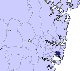
The Fairfield City Council is a local government area in the west of Sydney, in the state of New South Wales, Australia. The council was first incorporated as the "Municipal District of Smithfield and Fairfield" on 8 December 1888, and the council's name was changed to the "Municipality of Fairfield" in 1920, before being proclaimed a city in 1979. The City of Fairfield comprises an area of 102 square kilometres (39 sq mi) and as of the 2016 census had a population of 198,817. The Mayor of the City of Fairfield is Cr. Frank Carbone, the first popularly-elected independent mayor of Fairfield.

Marrickville Council was a local government area located in the inner west region of Sydney, Australia. It was originally created on 1 November 1861 as the "Municipality of Marrickville". On 12 May 2016, Marrickville Council was merged with Ashfield and Leichhardt councils into the newly formed Inner West Council.

The City of Parramatta Council is a local government area located west of central Sydney in the Greater Western Sydney region. Parramatta Council is situated between the City of Ryde and Cumberland, where the Cumberland Plain meets the Hornsby Plateau, approximately 25 kilometres (16 mi) west of the Sydney central business district, in the state of New South Wales, Australia.
Brooklet may refer to the following places:

Ballina Shire is a local government area in the Northern Rivers region of New South Wales, Australia. The Shire was formed on 1 January 1977 by the amalgamation of the Municipality of Ballina and Tintenbar Shire. The Shire is located adjacent to the Tasman Sea and the Pacific Highway. The Council seat is located in the town of Ballina. The population of the Ballina Shire area was 44,208 in June 2018.

The New South Wales State Heritage Register, also known as NSW State Heritage Register, is a heritage list of places in the state of New South Wales, Australia, that are protected by New South Wales legislation, generally covered by the Heritage Act 1977 and its 2010 amendments. The register is administered by the Heritage Council of NSW via Heritage NSW, a division of the Government of New South Wales Department of Premier and Cabinet.

The Municipality of Petersham was a local government area of Sydney, New South Wales, Australia. The small municipality was proclaimed as a borough in 1871 and was centred on the suburbs of Lewisham, Petersham and Stanmore. It was bounded by Parramatta Road in the north, Cardigan and Liberty Streets in the east, Stanmore and New Canterbury Roads in the south, and Old Canterbury Road in the west. The municipality was divided into three wards: South Kingston, Annadale and Sydenham, all the names of early farms. The boundaries remained fairly stable, with only minor changes on the east and western sides. The borough became a municipality in 1906. In 1949 under the Local Government (Areas) Act 1948, Petersham council was merged with the larger neighbouring Marrickville Council which was located immediately to the south.

The Municipality of Darlington was a local government area of Sydney, New South Wales, Australia. The municipality was proclaimed in 1864 and, with an area of 0.2 square kilometres, was the smallest municipal council in Sydney. It included the entire suburb of Darlington, excepting a small block between Golden Grove and Forbes streets, which was administered by the Municipality of Redfern in Golden Grove Ward. The council was amalgamated, along with most of its neighbours, with the City of Sydney to the north with the passing of the Local Government (Areas) Act 1948. From 1968 to 1982 and from 1989 to 2004, the area was part of the South Sydney councils.

The Municipality of Paddington was a local government area of Sydney, New South Wales, Australia. The municipality was proclaimed on 17 April 1860 and, with an area of 1.7 square kilometres, included the entire suburb of Paddington and parts of Edgecliff. The council was amalgamated with the City of Sydney to the east with the passing of the Local Government (Areas) Act 1948, although the former council area was transferred in 1968 to the Municipality of Woollahra, transferred to the City of South Sydney in 1989 and was then split in 2003 between the City of Sydney and the Municipality of Woollahra.

The Municipality of Bexley was a local government area in the St George region of Sydney, New South Wales, Australia. The municipality was proclaimed as the Borough of Bexley on 28 June 1900 when it formally separated from the Municipal District of Hurstville, and included the modern suburbs of Bexley, Bexley North and Kingsgrove, with parts of Carlton, Bardwell Park, Bardwell Valley, Rockdale and Kogarah. From 1 January 1949, the council was amalgamated into the Municipality of Rockdale, with the passing of the Local Government (Areas) Act 1948.

The Municipality of St Peters was a local government area of Sydney, New South Wales, Australia. It was originally proclaimed as the Municipal District of St Peters on 13 January 1871. With an area of 4.2 square kilometres, it included the modern suburbs of St Peters, Tempe and Sydenham. The council was amalgamated with the Municipality of Marrickville, along with the Municipality of Petersham, with the passing of the Local Government (Areas) Act 1948, and is now part of the Inner West Council.

The Municipality of Mascot was a local government area in the inner south of Sydney, New South Wales, Australia. The municipality was proclaimed as the Borough of North Botany on 29 March 1888 and was renamed to the Municipality of Mascot, in order to differentiate itself from their southern neighbour, from 31 October 1911. It included the modern suburbs of Eastlakes and Daceyville, with parts of Mascot and Pagewood. From 1 January 1949, the council was amalgamated into the Municipality of Botany, with the passing of the Local Government (Areas) Act 1948.

The Municipality of Lidcombe was a local government area in the Western region of Sydney, New South Wales, Australia. The municipality was proclaimed as the Borough of Rookwood on 8 December 1891 and was renamed to the Municipality of Lidcombe, a portmanteau of two mayor's names, in order to differentiate itself from the expanding necropolis, from 15 October 1913. It included the modern suburbs of Rookwood, Lidcombe, Homebush Bay, Berala and parts of Newington, Silverwater, Homebush West and Regents Park. From 1 January 1949, the council was amalgamated into the Municipality of Auburn, with the passing of the Local Government (Areas) Act 1948.
The 2017–18 Women's National Cricket League season was the 22nd season of the Women's National Cricket League, the women's domestic limited overs cricket competition in Australia. The tournament started on 6 October 2017 and finished on 24 February 2018.
