
Virginia is a city in Cass County, Illinois, United States. The population was 1,611 at the 2010 census. It is the county seat of Cass County.

Delanson is a village in Schenectady County, New York, United States. The population was 377 at the 2010 census. Delanson is in the southeastern portion of the town of Duanesburg.

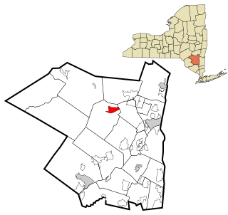
Olive is an interior town in Ulster County, New York, United States. The town is west of Kingston, New York and is inside the Catskill Park. The population was 4,419 at the 2010 census.
Shokan is a hamlet located in the Town of Olive in Ulster County, New York, United States, within the Catskill Park. The population was 1,183 at the 2010 census.

West Hurley is a hamlet in Ulster County, New York, United States. The population was 1,939 at the 2010 census.
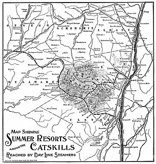
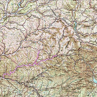
The Ulster and Delaware Railroad (U&D) was a railroad located in the state of New York. It was often advertised as "The Only All-Rail Route to the Catskill Mountains." At its greatest extent, the U&D extended 107 miles (172 km) from Kingston Point on the Hudson River through the Catskill Mountains to its western terminus at Oneonta, passing through the counties of Ulster, Delaware, Schoharie and Otsego.

Boiceville Railroad Station was built by the Ulster and Delaware Railroad to serve the community of Boiceville, New York. Located at MP 21.3, Boiceville was the westernmost depot to be removed as a result of the construction of the Ashokan Reservoir. Although the community of Boiceville was submerged, the station site remains above the reservoir level, at a point just west of where the old railroad right of way slips under the waters of the reservoir, and just east of where it diverges from the new line.

The Ashokan Reservoir is a reservoir in Ulster County, New York. It is at the eastern end of the Catskill Park, and is one of several in the region created to provide the City of New York with water. It is the city's deepest reservoir at 190 feet (58 m) near the dam at the former site of Bishop Falls.

Ashokan was a former railroad station located in the Shokan section of the town of Olive, Ulster County, New York, United States. Located 16.2 miles (26.1 km) from the terminus at Kingston Point in Kingston, it was located along the Ulster and Delaware Railroad, later the Catskill Mountain Branch of the New York Central Railroad. The station opened on June 8, 1913, when the railroad abandoned their former alignment due to the construction of the Ashokan Reservoir. The railroad moved the station depot at Brown's Station to Ashokan for service.

The Catskill Mountain Railroad is a heritage tourist railroad based in Kingston, New York, that began operations in 1982. The railroad leases a 4.7-mile portion of the former New York Central Railroad Catskill Mountain branch from Kingston to Stony Hollow, New York. The tracks are owned by Ulster County, New York, which bought them in 1979 from the bankruptcy estate of the Penn Central Railroad. The railroad's current permit with Ulster County expired on December 31, 2021. However, the Ulster County Legislature voted 17 to 5 on December 21, 2021, to extend the CMRR's permit until December 31, 2023.

Cold Brook is a former railroad station in the Boiceville section of the town of Olive, Ulster County, New York, United States. Located on Cold Brook Road, just north of New York State Route 28A next to Esopus Creek, Cold Brook station served the New York Central Railroad's Catskill Mountain Branch, formerly the Ulster and Delaware Railroad. The station was located 22.1 miles (35.6 km) northwest of Kingston Point station in the city of Kingston.
The Delaware and Northern Railroad was a small railroad in Delaware County, New York that was founded in 1905, and was planned to go from East Branch, where it would make a connection with the New York, Ontario and Western Railway, to Arkville, where it would connect with the Ulster and Delaware. This line followed close to the banks of the East Branch of the Delaware River, and had plans of expansion, but never made it far, only getting to Arkville. The line was scrapped in 1942, when the Pepacton Reservoir took over its right-of-way, and forced the D&N to go out of business.

Brown's Station was a hamlet in the Esopus Valley of southeastern Ulster County, New York, United States. It was submerged by the waters of the Ashokan Reservoir, an artificial lake built between 1906 and 1915 to supply fresh water to New York City.

The Schoharie Reservoir is a reservoir in the Catskill Mountains of New York State that was created to be one of 19 reservoirs that supplies New York City with water. It was created by impounding Schoharie Creek. Portions of it lie in the towns of Conesville and Gilboa in Schoharie County, Roxbury in Delaware County, and Prattsville in Greene County.

The Catskill Aqueduct, part of the New York City water supply system, brings water from the Catskill Mountains to Yonkers where it connects to other parts of the system.

The Loop is the 1.79-mile (2.88 km) long circuit of elevated rail that forms the hub of the Chicago "L" system in the United States. As of 2012, the branch has served 74,651 passengers every weekday. The Loop is so named because the elevated tracks loop around a rectangle formed by Lake Street, Wabash Avenue (east), Van Buren Street (south), and Wells Street (west). The railway loop has given its name to Chicago's downtown, which is also known as the Loop.

Villa Grove is an unincorporated community and a U.S. Post Office in Saguache County, Colorado, United States. The Villa Grove Post Office has the ZIP Code 81155.
Olivebridge is a hamlet in the town of Olive, Ulster County, New York, United States, within Catskill Park and the Catskill Mountains.

Cecil Township is a civil township in Bottineau County in the U.S. state of North Dakota. As of the 2000 census, its population was 28.
Cambridge is an extinct town in Saline County, in the U.S. state of Missouri. The GNIS classifies it as a populated place.
