Browne's Addition, Spokane

Last updated
Browne's Addition
Campbell House Spokane 2018.jpg
The historic Campbell House
Browne's Additioncropped.png
Location within the city of Spokane
Coordinates: 47°39′20.0″N117°26′29.8″W / 47.655556°N 117.441611°W / 47.655556; -117.441611
CountryUnited States
StateWashington
County Spokane
CitySpokane
Population
 (2017 [1] )
  Total2,959
Demographics 2017
   White 74.8%
  Latinx7.1%
  Black5.9%
  Asian/Native Hawaiian/Pacific Islander6.2%
Time zone UTC-8 (PST)
  Summer (DST) UTC-7 (PDT)
ZIP Codes
99201
Area code 509

Browne's Addition, often referred to shorthand as just Browne's, is a neighborhood in Spokane, Washington. It is located directly west of Downtown Spokane and is one of the oldest and densest neighborhoods in the city. The area is known for its numerous historic mansions, many of which have been converted into multi-family apartments. The terrain is flat in the neighborhood despite the degree of topographical relief in the immediate surrounding area. Latah Creek cuts a deep valley to the west, separating Browne's Addition from the Sunset Hill portion of the West Hills neighborhood and the Spokane River gorge drops off dramatically to the north into the Peaceful Valley neighborhood. The South Hill area of Spokane rises to the southwest.

Contents

Browne's Addition is known as one of Spokane's centers of culture, with its collection of historic structures, vibrant culinary and nightlife scene, numerous community festivals, and for being the location of the Northwest Museum of Arts and Culture.

Geography

Bridges crossing Latah Creek from Browne's Addition (left) to the West Hills. Bridges crossing Latah Creek.jpg
Bridges crossing Latah Creek from Browne's Addition (left) to the West Hills.

Browne's Addition is immediately to the west of Downtown Spokane. There is something of an interface area between Downtown and Browne's in the Carnegie Square area, which straddles the border between the two neighborhoods on Riverside and 1st Avenues. [2] Spokane Fire Department Station 4 is located on the Browne's Addition side of this interface, surrounded by the off-and-on-ramps of the Maple Street Bridge. [3]

The Spokane River cuts a deep gorge to the north of Browne's Addition, with the Peaceful Valley neighborhood occupying the area between the slope and the river itself. Latah Creek, which flows into the Spokane River a few hundred feet northwest of Browne's Addition, cuts a similarly deep valley to the west of the neighborhood, forming the border between Browne's Addition and the High Bridge Park portion of the Latah/Hangman neighborhood. Sunset Boulevard, which crosses Latah Creek to connect the Sunset Hill area of the West Hills neighborhood with Browne's Addition, Downtown Spokane and the rest of the city, acts as the southern border of the neighborhood. Though, the elevated railroad tracks running adjacent to and immediately south of Sunset Boulevard are the official boundary between Browne's Addition and the Cliff/Cannon Neighborhood of the South Hill. [3]

Riverside Avenue passes from Downtown Spokane through the northern edge of the neighborhood, providing an arterial and thoroughfare through the neighborhood down into Peaceful Valley and on into the West Hills. Pacific Avenue and Second Avenue provide the main east-to-west thoroughfares through the neighborhood, with both coming to an end on the western edge of Browne's Addition. Sunset Boulevard on the south, like Riverside on the north, is a thoroughfare that goes through and beyond the neighborhood. There are no true north-south arterials in the neighborhood, due to the gorge cut by the river to the north and the elevated railroad tracks to the south. Cannon Street acts as the closest thing to a north-south arterial in the neighborhood, as its roundabout intersection with Pacific Avenue can be considered to be the heart of the neighborhood. [4]

The City Line bus rapid transit route is, as of 2021, under construction in Browne's Addition. It will connect the neighborhood, on its western end, to Spokane Community College in Chief Garry Park via Downtown Spokane and Gonzaga University. It is expected to open in 2023, though infrastructure for the line has been constructed in the neighborhood as of 2021. [5]

Coeur d'Alene Park, named for nearby Coeur d'Alene, Idaho is located in the middle of the neighborhood. It takes up four square blocks centered on Third Avenue and Hemlock Street and provides basketball courts, tennis courts, a playground, restrooms, picnic facilities and a gazebo in the center. Tall, old ponderosa pine trees are common throughout the park and neighborhood. [6]

History

The Loewenberg-Roberts House, a historic mansion that now operates as a bed and breakfast and events center Roberts Bed & Breakfast (6063397770).jpg
The Loewenberg-Roberts House, a historic mansion that now operates as a bed and breakfast and events center

The Spokane people inhabited the area that is now known as Browne's Addition for thousands of years prior to the arrival of European settlers. The area was part of the tribe's wintering ground. Development and growth in the neighborhood, particularly on tribal burial grounds, continues to be a point of contention as of 2020. [7]

Browne's Addition was Spokane's first neighborhood. [8] It is home to numerous historical structures that date back to the early days of Spokane. Its namesake, J.J. Browne, arrived in Spokane in 1878. Browne, along with A.M. Cannon, namesake of the Cliff/Cannon neighborhood to the south, bought a quarter of the Spokane townsite from its founder, James Glover. They later added 160 acres to the west of the townsite that would eventually become the Browne's and Cannon's Additions. [9]

Chinese immigrants played a critical, if forgotten, role in the early city of Spokane and the Browne's Addition neighborhood. Racial enmity between white and Chinese settlers was problematic. There was a Chinese cemetery on the western edge of Pacific Avenue in the 1880s, though the graves were later exhumed and the remains moved to China. [9]

The Northwest Museum of Arts and Culture Spokane Museum of Art and Culture.JPG
The Northwest Museum of Arts and Culture

Browne's Addition was home to many of the mining magnates from the surrounding region, who sought out the ability to live luxuriously away from, but within reach of, the rowdy mining areas from which they profited. As a result, many large mansions were built in the neighborhood, including the historic Campbell House. [10] Many of these mansions remain today, with some still serving as single-family housing but the majority have moved onto other uses. Some, like the Campbell House on the campus of the Northwest Museum of Arts and Culture are preserved for their historic value, while others like the Patsy Clark Mansion, have become commercial spaces. Most, however, serve as multi-family apartment-style dwellings, a trend which began in the 1920s. [8]

As urban decay took hold in the middle of the 20th century, Browne's Addition's fortunes turned. No longer was it the home for the wealthiest in the community; its mansions became divided up into apartments and some smaller dwellings were torn down to make room for multi-family housing. Crime and drug addiction became rampant to the point that the neighborhood was often referred to as "Browne's Addiction." [8]

Since the 1990s that stigma has faded as the neighborhood has seen reinvestment. It is now the most culturally diverse neighborhood in Spokane and home to residents of all income levels, with some condominiums selling for $600,000 and some apartments renting for $300 per month as of 2009. That same year, the American Planning Association listed Browne's Addition as one of its ten best neighborhoods in the country. [4] The revitalization of the neighborhood has not come without controversy, however, as many residents see the new developments as detrimental to the historic nature of the neighborhood. [11]

Historic places

Browne's Addition is home to six individual properties listed on the National Register of Historic Places, many of which are also listed as contributing to the NRHP's Browne's Addition Historic District which comprises most of the area of the neighborhood.

[12] Name on the RegisterImageDate listed [13] LocationDescription
1 Amman
Amman Amman Building NRHP 87000086 Spokane County, WA.jpg
Amman
February 12, 1987
(#87000086)
W. 1516 Riverside
47°39′25″N117°26′01″W / 47.656944°N 117.433611°W / 47.656944; -117.433611 (Amman)
Built in 1904.
2 Campbell House
Campbell House Campbell House Spokane 2018.jpg
Campbell House
May 31, 1974
(#74001979)
W. 2316 1st Ave.
47°39′25″N117°26′45″W / 47.656944°N 117.445833°W / 47.656944; -117.445833 (Campbell House)
Built in 1898, this house is now part of the Northwest Museum of Arts and Culture.
3 Patsy Clark Mansion
Patsy Clark Mansion Patsy Clark Mansion1.JPG
Patsy Clark Mansion
October 31, 1975
(#75001873)
W. 2208 2nd Ave.
47°39′19″N117°26′39″W / 47.655278°N 117.444167°W / 47.655278; -117.444167 (Patsy Clark Mansion)
4 Coeur d'Alene Park
Coeur d'Alene Park Coeur d'Alene Park NRHP100003228 Spokane County, WA.jpg
Coeur d'Alene Park
December 12, 2018
(#100003228)
2111 W 2nd Ave.
47°39′13″N117°26′41″W / 47.6536°N 117.4447°W / 47.6536; -117.4447 (Coeur d'Alene Park)
5 Finch House
Finch House Finch House 2.JPG
Finch House
July 12, 1976
(#76001917)
W. 2340 1st Ave., S. 104 Poplar
47°39′27″N117°26′48″W / 47.6575°N 117.4467°W / 47.6575; -117.4467 (Finch House)
Built circa 1897, this home was designed by Kirtland Cutter & Karl G. Malmgren of Cutter & Malmgren.
6 Sunset Boulevard Bridge
Sunset Boulevard Bridge Sunset Boulevard Bridge.jpg
Sunset Boulevard Bridge
July 16, 1982
(#82004293)
Spans Latah Creek
47°39′00″N117°26′48″W / 47.65°N 117.446667°W / 47.65; -117.446667 (Sunset Boulevard Bridge)
Built 1911-14. Historic Bridges and Tunnels in Washington TR. Extends into West Hills.

Demographics

As of 2017, 2,959 people live in Browne's Addition across 1,977 households. 86.4% of households are rented, well above the citywide average of 45.3%. People aged 19 and under account for 9.9% of the population, while those 65 and above account for 11.8% of the population, both of which are below their citywide averages. Browne's Addition is known for its young, but adult, population. The median household income is $28,760 and the unemployment rate is 8.2%. In terms of education, 13.5% of the population has nothing more than a high school diploma, well below the citywide average, and 41.8% have a bachelor's degree or above, well above the citywide average. 94.4% of the population was born in the United States. Of the foreign born residents, 27.8% are from Japan, 23.8 from Ethiopia, 11.5% from Vietnam and 7.9% from Norway. [1]

It is known as a hip neighborhood for young adults, with many students and service-industry workers calling it home. [14]

Education

Browne's Addition is served by Spokane Public Schools. There are no schools in the neighborhood. It is part of the Roosevelt Elementary district, located in the adjacent Cliff/Cannon neighborhood. Roosevelt feeds into Sacajawea Middle School in the Comstock neighborhood and then into Lewis and Clark High School. [15] [16]

Transportation

Surface streets

Hemlock Street looking south towards Coeur d'Alene Park Hemlock Street, Browne's Addition, Spokane, WA (53796319161).jpg
Hemlock Street looking south towards Coeur d'Alene Park

Located directly west of downtown Spokane, the neighborhood is well integrated in the city's street grid plan. The neighborhood has three principal arterial streets, Maple Street, Walnut Street, and Sunset Boulevard. Only Sunset Boulevard traverses the neighborhood, doing so diagonally across its southern boundary, while Maple Street and Walnut Street only briefly transit the neighborhood on its northeast corner, where there is a junction that forms the Maple Street/Walnut Street couplet. Riverside Avenue is classified by the city as a major collector street in the neighborhood, running east to west across the neighborhoods northern boundary. The rest of the streets are considered to be local access roads. [17]

Public transit

The Spokane Transit Authority, the region's public transportation provider, serves Browne's Addition with three fixed schedule bus lines. [18]

RouteTerminiService operation and notesStreets traveled
1
City Line
Browne's Addition Chief Garry Park
Spokane Community College
Bus rapid transit routeCannon St, 4th Ave, 1st Ave, 2nd Ave
20
SFCC
Downtown Spokane
STA Plaza
West Hills
Spokane Falls Community College
High-frequency routeRiverside
60
Airport via Browne's Addition
Downtown Spokane
STA Plaza
West Hills
Spokane International Airport
Basic-frequency routeRiverside, Maple, Pacific, Spruce, Fourth, Cannon, Sunset
61
Hwy 2 via Browne's Addition
Downtown Spokane
STA Plaza
Airway Heights, Washington
Fairchild Air Force Base
Basic-frequency routeRiverside, Maple, Pacific, Spruce, Fourth, Cannon, Sunset

Related Research Articles

<span class="mw-page-title-main">Neighborhoods in Spokane, Washington</span>

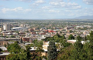
Neighborhoods in Spokane, Washington are officially grouped by the Spokane City Council into three main city council districts: 1, 2, and 3. Each city council district contains multiple, official neighborhoods that are recognized with a neighborhood council. Informally, neighborhoods are colloquially grouped by local geographical, geological, cultural, or historical features The list of neighborhoods below is organized based on the official designations by the City of Spokane. Unofficial neighborhoods and districts are listed within the official neighborhood in which they are located.

<span class="mw-page-title-main">High Bridge Park</span> Park in Spokane, Washington, United States of America

High Bridge Park is a 200 acres (810,000 m2) public park located at Riverside Ave. and A St. in Latah/Hangman, Spokane, Washington. It is open daily, without charge.

<span class="mw-page-title-main">West Central, Spokane</span> Neighborhood in Spokane, Washington, U.S.

West Central is a neighborhood in Spokane, Washington. As the name suggests it is located centrally on the west side of the city. Downtown Spokane is immediately east of the neighborhood, and spreads into West Central along Monroe Street in the Kendall Yards area. The neighborhood is diverse, with single and multi-family residential zones dating back to the early days of Spokane, a new mixed use development on the site of a former rail yard, the Spokane County Courthouse campus and associated government buildings and a few commercial districts. The Spokane River gorge winds around the southern and western edge of the neighborhood. It is home to Nettleton's Addition Historic District, which was added to the National Register of Historic Places in March 2006, and is also the largest historic district on the Washington State Heritage Register.

<span class="mw-page-title-main">Bemiss, Spokane</span> Neighborhood in Spokane, Washington, United States

Bemiss is a neighborhood in Spokane, Washington. It is located within City Council District 1, which covers the northeastern section of the city. The neighborhood is bounded by Wellesley Avenue to the north, Market Street to the east, Illinois Avenue and the Spokane River to the south, and Perry Street and Napa Street to the west. It is located to the southeast of the Hillyard neighborhood and is often grouped into greater Hillyard.

<span class="mw-page-title-main">Chief Garry Park, Spokane</span> Neighborhood in Spokane, Washington, United States

Chief Garry Park is a neighborhood in Spokane, Washington. It is located immediately south of the Spokane River. It is named for Spokane Garry and a park that has taken his name. The neighborhood was first established in 1912 but it wasn't until 1932 that it was officially named for Chief Garry.

<span class="mw-page-title-main">Logan, Spokane</span> Spokane Neighborhood in Washington, United States

Logan is a neighborhood in Spokane, Washington. It is located immediately northeast of Downtown Spokane and is home to Gonzaga University. The Spokane River runs along its eastern and southern edge. Due to its proximity to the city center, Logan is home to some of the oldest and densest areas in the city. It is known for its tree-lined streets, historic buildings and population of college students. In addition to numerous individual properties, there are two historic districts listed on the National Register of Historic Places located within Logan: the Desmet Avenue Warehouse Historic District and the Mission Avenue Historic District.

<span class="mw-page-title-main">Peaceful Valley, Spokane</span> Spokane Neighborhood in Washington, United States

Peaceful Valley is a neighborhood in Spokane, Washington. It sits directly below Downtown Spokane on the Spokane River under its falls. The neighborhood snakes along the thin floodplain on the valley floor of the Spokane River Gorge. It is the smallest neighborhood in the city by both area and population, but due to its central location and unique character it is quite notable. The neighborhood has a working class and bohemian culture.

<span class="mw-page-title-main">Rockwood, Spokane</span> Spokane Neighborhood in Washington, United States

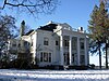
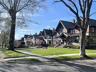
Rockwood is a neighborhood in Spokane, Washington. It is located on the south side of the city to the southeast of Downtown Spokane and expanding southeasterly from close to the city center. Its proximity to downtown makes it one of Spokane's older neighborhoods, with mature trees lining most of its streets. Due to its location on the hill leading up from the Spokane River Valley, the street grid breaks down in many places around Rockwood. The most notable of these is along the winding Rockwood Boulevard, which was designed by the Olmsted Brothers and weaves its way from the northwesternmost corner of the neighborhood through the center and across to the eastern border, highlighting the basalt bluffs and other natural topography.

<span class="mw-page-title-main">Manito/Cannon Hill, Spokane</span> Neighborhood in Spokane, Washington, United States

Manito/Cannon Hill is a neighborhood on the South Hill of Spokane, Washington. It is named after the two public parks that dominate its setting: Manito Park and Cannon Hill Park. Manito/Cannon Hill is a predominantly residential neighborhood made up mostly by single-family homes and city park land.

<span class="mw-page-title-main">Cliff/Cannon, Spokane</span> Neighborhood in Spokane, Washington, United States

Cliff/Cannon is a neighborhood in Spokane, Washington. It is located immediately south of Downtown, Spokane, and on the lower reaches of the broader South Hill. The neighborhood is home to a medical district with Sacred Heart and Deaconess both having their main hospital campuses along Cliff/Cannon's denser northern edge. To the south the neighborhood becomes more residential. City parks break up the residential zoning of the southern half of Cliff/Cannon. It is adjacent to the Cannon Hill area of the neighboring but separate Manito/Cannon Hill neighborhood. The Marycliff-Cliff Park Historic District, a National Historic District listed on the National Register of Historic Places, is located within the neighborhood.

<span class="mw-page-title-main">Latah/Hangman, Spokane</span> Spokane Neighborhood in Washington, United States

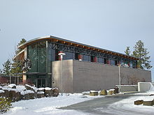
Latah/Hangman is a neighborhood in Spokane, Washington.

<span class="mw-page-title-main">Emerson/Garfield, Spokane</span> Spokane Neighborhood in Washington, United States

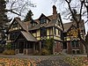
Emerson/Garfield is a neighborhood in Spokane, Washington. It is located immediately north of Downtown Spokane's North Bank and extends out into the inner northwestern portion of the city. Emerson/Garfield is a diverse neighborhood with residential, commercial and civic zones all bordering one another, with density ranging from single-family homes to multi-use buildings. Due to its location in the central area of Spokane, Emerson/Garfield is criss-crossed by numerous arterials and thoroughfares. Along those main roads are numerous commercial and retail districts of importance to both the neighborhood and city as a whole.

<span class="mw-page-title-main">Comstock, Spokane</span> Neighborhood in Washington, United States

Comstock is a neighborhood in Spokane, Washington. It is located on the south side of the city in a broader area commonly known as the South Hill. The neighborhood is primarily single-family residential, and a mix of homes built during the streetcar era and then built during the post-World War II housing boom. The neighborhood is also home to a few commercial districts, including the regionally important Manito Shopping Center, two schools, the eponymous Comstock Park, sports fields and a golf course.

<span class="mw-page-title-main">Southgate, Spokane</span> Spokane Neighborhood in Washington, United States

Southgate is a neighborhood in Spokane, Washington. It is located in the southwestern corner of the City of Spokane and part of the broader area known locally as the South Hill. Southgate is one of the newer neighborhoods in the city, with development first taking hold in the post-World War II housing boom and continuing into the present day. It is a mix of single-family residential, multi-family residential and commercial districts. The neighborhood has grown as Spokane has expanded southward, with multiple annexations expanding Southgate and the city since 2000 and as recently as 2016.

<span class="mw-page-title-main">Grandview/Thorpe, Spokane</span> Spokane Neighborhood in Washington, United States

Grandview/Thorpe is a neighborhood in Spokane, Washington. Located in southwestern Spokane, the neighborhood takes its name from two roads that pass through. Grandview Boulevard, so named because of its location at the top of a ridge from which large swaths of Spokane, the Spokane Valley and surrounding mountains to the north and east such as Mount Spokane, can be seen, is located in the northern part of the neighborhood. Thorpe Road traverses a gully in the central and southern portion of the neighborhood.

<span class="mw-page-title-main">West Hills, Spokane</span> Spokane Neighborhood in Washington, United States

West Hills is a neighborhood in Spokane, Washington. As the name suggests, the neighborhood is located on hillsides to the west of downtown Spokane. The neighborhood also extends far to the west along the West Plains to incorporate the Spokane International Airport and surrounding land. As the city has grown over the decades, the West Hills neighborhood has expanded uphill and onto the plains to the west. That history of incremental growth, combined with the hilly topography of the area cut by numerous watercourses, has broken up the neighborhood into multiple, distinct areas with swaths of undeveloped land mixed in between.

<span class="mw-page-title-main">Audubon/Downriver, Spokane</span> Spokane Neighborhood in Washington, United States

Audubon/Downriver is a neighborhood in Spokane, Washington, located on the northwest side of the city. There is a diversity of land use in the neighborhood, with single-family residential areas dating from the early 20th century through the Post–World War II economic expansion era, regionally important commercial districts, smaller neighborhood retail areas, numerous schools, large parks, a golf course, conservation areas and part of Riverside State Park along the Spokane River. The neighborhood is the site of the corporate offices for Rosauers Supermarkets, a regional grocery store chain with stores located across the Northwestern United States.

<span class="mw-page-title-main">Northwest, Spokane</span> Spokane Neighborhood in Washington, United States

Northwest is a neighborhood in Spokane, Washington, located in the northwestern portion of the city. Largely single-family residential, Northwest is also home to Spokane's VA Medical Center, the Dwight Merkel Sports complex, a large public sports facility, and portions of Riverside State Park along the Spokane River. The neighborhood contains developments that span from the post-World War II housing boom in the east to more contemporary, suburban-style developments in the west. It was also home to Joe Albi Stadium from 1950 until 2022, which served as the Spokane region's main high school sports stadium over its seven decades of use.

<span class="mw-page-title-main">Sunset Boulevard Bridge</span> Bridge in Washington, U.S.

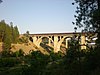
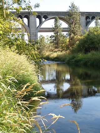
The Sunset Boulevard Bridge, also known as the Latah Creek Bridge, is a deck arch bridge in the northwestern United States that spans Latah Creek in Spokane, Washington. The bridge connects the neighborhoods of Browne's Addition on the east, and Downtown Spokane just beyond that, with West Hills to the west. Latah Creek, which passes under the bridge, separates the two neighborhoods. It was built 113 years ago in 1911 by the city of Spokane, and was designed by Morton McCartney & J.F. Cunningham, with J.F. Greene serving as the construction engineer.

<span class="mw-page-title-main">Ninth Avenue Historic District</span> Historic district in Spokane, Washington

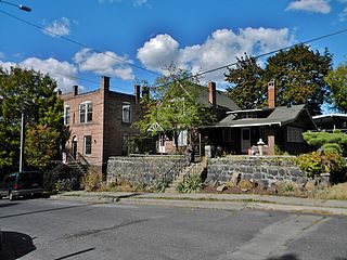
The Ninth Avenue Historic District is a National Register of Historic Places (NRHP) listed historic district located along and around Ninth Avenue in the Cliff/Cannon neighborhood of Spokane, Washington. It stretches from Monroe Street on the east to Chestnut Street on the west, running the length of Ninth Avenue and extending to include portions of Eighth, 10th and 11th Avenues, mostly in the western half of the district.

References

  1. 1 2 "Browne's Addition Neighborhood Snapshot" (PDF). spokanecity.org. City of Spokane. Retrieved 30 October 2021.
  2. "Carnegie Square". historicspokane.org. City - County of Spokane Historic Preservation Office. Retrieved 30 October 2021.
  3. 1 2 "Browne's Addition Map" (PDF). spokanecity.org. City of Spokane. Retrieved 30 October 2021.
  4. 1 2 "Browne's Addition: Spokane, Washington". planning.org. American Planning Associated. Retrieved 30 October 2021.
  5. Brown, Sydney (8 October 2021). "Spokane's city transit line will have to wait another year, slated to open July 2023". The Spokesman-Review. Retrieved 30 October 2021.
  6. Rebstock, Tracy L. "Spokane's First Park: Coeur d'Alene Park". spokanehistorical.org. Spokane Historical. Retrieved 30 October 2021.
  7. Wohlfeil, Samantha (16 January 2020). "A small development at the edge of Browne's Addition has come under fire, in part because of its proximity to a tribal burial site". The Inlander. Retrieved 30 October 2021.
  8. 1 2 3 Wnek, Zachary. "Tour | Browne's Addition". spokanehistorical.org. Spokane Historical. Retrieved 30 October 2021.
  9. 1 2 "Browne's Addition Neighborhood Profile" (PDF). spokanecity.org. City of Spokane. Retrieved 30 October 2021.
  10. "Campbell House". northwestmuseum.org. Northwest Museum of Arts and Culture. Retrieved 30 October 2021.
  11. Prager, Mike. "Browne's Addition looking for extra historic protections". The Spokesman-Review. No. 28 November 2016. Retrieved 30 October 2021.
  12. Numbers represent an alphabetical ordering by significant words. Various colorings, defined here, differentiate National Historic Landmarks and historic districts from other NRHP buildings, structures, sites or objects.
  13. The eight-digit number below each date is the number assigned to each location in the National Register Information System database, which can be viewed by clicking the number.
  14. Vent, Terence (24 May 2018). "Historic Browne's Addition holds onto its roots: Neighborhood council seeks balance between old, new". The Spokesman-Review. Retrieved 30 October 2021.
  15. "Elementary School Boundary Map" (PDF). spokaneschools.org. Spokane Public Schools. Archived from the original (PDF) on 2021-11-28. Retrieved 14 June 2022.
  16. "High School Boundary Map" (PDF). spokaneschools.org. Spokane Public Schools. Archived from the original (PDF) on 2021-07-10. Retrieved 14 June 2022.
  17. "City of Spokane Arterial Street Map" (PDF). City of Spokane. Retrieved July 17, 2024.
  18. "STA System Map" (PDF). spokanetransit.com. Spokane Transit Authority. Retrieved 18 June 2022.