Brownsville-Brent-Goulding, Florida

Last updated
Brownsville-Brent-Goulding
Former CDP
USA Florida location map.svg
Red pog.svg
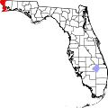
Brownsville-Brent-Goulding
Location within the state of Florida
Coordinates: 30°26′14″N87°13′50″W / 30.43722°N 87.23056°W / 30.43722; -87.23056 Coordinates: 30°26′14″N87°13′50″W / 30.43722°N 87.23056°W / 30.43722; -87.23056
Country United States
State Florida
County Escambia
Population
 (1950)
  Total20,269
Time zone UTC-6 (Central (CST))
  Summer (DST) UTC-5 (CDT)

Brownsville-Brent-Goulding was a Census-designated place in Escambia County, Florida during the 1950 United States Census, which consists of the communities of Brent, Brownsville, Goulding and West Pensacola. [1] [2] The population in 1950 was 20,269. [3]

The census area's name was reduced to just "Brownsville" during the 1960 Census, when the population increased to 38,417. [4] During the 1970 census, the census area was reduced and was reassigned to West Pensacola, with a recorded population of 20,924. [5] The communities of Brent and Goulding were not returned separately by census enumerators until 1980. [6]

Geography

The census area of Brownsville-Brent-Goulding was located northwest of Pensacola and northeast of Warrington, the only existing CDP in the county enumerated since the concept began in 1950. [7]

Related Research Articles

<span class="mw-page-title-main">Escambia County, Florida</span> County in Florida, United States

Escambia County is the westernmost and oldest county in the U.S. state of Florida. It is in the state's northwestern corner. At the 2020 census, the population was 321,905. Its county seat and largest city is Pensacola. Escambia County is included within the Pensacola-Ferry Pass-Brent, Florida, Metropolitan Statistical Area. The county population has continued to increase as the suburbs of Pensacola have developed.

<span class="mw-page-title-main">Santa Rosa County, Florida</span> County in Florida, United States

Santa Rosa County is a county located in the northwestern portion of the U.S. state of Florida. As of 2020, the population is 188,000. The county seat is Milton, which lies in the geographic center of the county. Other major communities within Santa Rosa County are Navarre, Pace, and Gulf Breeze. Navarre is the most populated community with a population of approximately 45,000 residents. Santa Rosa County is included in the Pensacola Metropolitan Statistical Area, which also includes Escambia County.

<span class="mw-page-title-main">Brent, Florida</span> Census-designated place in Florida, United States

Brent is a census-designated place (CDP) in Escambia County, Florida, United States. The population was 21,804 at the 2010 census. It is a principal city of the Pensacola-Ferry Pass-Brent Metropolitan Statistical Area. The community is named after Francis Celestino Brent, who played an integral role in the development of Pensacola.

<span class="mw-page-title-main">Century, Florida</span> Town in Florida, United States

Century is a town in Escambia County, Florida, United States. Per the 2020 census, the population was 1,713. It is part of the Pensacola–Ferry Pass–Brent Metropolitan Statistical Area.

<span class="mw-page-title-main">Goulding, Florida</span> Census-designated place in Florida, United States

Goulding is a census-designated place (CDP) in Escambia County, Florida, United States. The population was 4,102 at the 2010 census. It is part of the Pensacola–Ferry Pass–Brent Metropolitan Statistical Area.

<span class="mw-page-title-main">Pensacola, Florida</span> City in Florida, United States

Pensacola is the westernmost city in the Florida Panhandle, and the county seat and only incorporated city of Escambia County, Florida, United States. At the 2020 United States census, the population was 54,312. Pensacola is the principal city of the Pensacola Metropolitan Area, which had an estimated 502,629 residents in 2019.

<span class="mw-page-title-main">Warrington, Florida</span> CDP in Florida, United States

Warrington is a census-designated place (CDP) in Escambia County, Florida, United States. Warrington is located between downtown Pensacola and the state line with Alabama; it is 6 miles (10 km) away from both.

<span class="mw-page-title-main">West Pensacola, Florida</span> Census-designated place in Florida, United States

West Pensacola is a census-designated place (CDP) in Escambia County, Florida, United States. The population was 21,339 at the 2010 census. It is part of the Pensacola–Ferry Pass–Brent Metropolitan Statistical Area. The CDP area includes the community of Brownsville.

<span class="mw-page-title-main">Brownsville, Florida</span> Census-designated place in Florida, United States

Brownsville is an unincorporated community and census-designated place (CDP) in metropolitan Miami, Florida, United States. As of the 2010 census, the population was 16,583, up from 15,313 in 2010. After three decades of population loss, Brownsville gained population for the first time in over 40 years in the 2010 US Census.

<span class="mw-page-title-main">Princeton, Florida</span> Census-designated place in Florida, United States

Princeton is a census-designated place (CDP) and unincorporated community in Miami-Dade County, Florida, United States. The population was 39,208 at the 2020 census, up from 22,038 at the 2010 census.

<span class="mw-page-title-main">Deep South</span> Cultural region of the United States

The Deep South or the Lower South is a cultural and geographic subregion of the Southern United States. The term was first used to describe the states which were most dependent on plantations and slavery prior to the American Civil War. Following the war, the region suffered economic hardship and was a major site of racial tension during and after the Reconstruction era. Before 1945, the Deep South was often referred to as the "Cotton States" since cotton was the primary cash crop for economic production. The civil rights movement in the 1950s and 1960s helped usher in a new era, sometimes referred to as the New South.

<span class="mw-page-title-main">Florida Panhandle</span> Northwest region of Florida

The Florida Panhandle is the northwestern part of the U.S. state of Florida; it is a salient roughly 200 miles (320 km) long and 50 to 100 miles wide, lying between Alabama on the north and the west, Georgia on the north, and the Gulf of Mexico to the south. Its eastern boundary is arbitrarily defined. In terms of population, major communities include Tallahassee, Pensacola, and Panama City.

<span class="mw-page-title-main">Pensacola metropolitan area</span> Metropolitan statistical area in Florida, United States

The Pensacola metropolitan area is the metropolitan area centered on Pensacola, Florida. It is also known as the Pensacola-Ferry Pass-Brent Metropolitan Statistical Area, a metropolitan statistical area (MSA) used for statistical purposes by the United States Census Bureau and other agencies. The Pensacola Standard Metropolitan Statistical Area was first defined after the 1960 United States Census, with Pensacola as the principal city, and included Escambia and Santa Rosa counties. Ferry Pass and Brent, which are unincorporated census-designated places in Escambia County, were added as principal cities after the 2000 Census. The population of the MSA in the 2020 census was 511,502.

The history of Pensacola, Florida, begins long before the Spanish claimed founding of the modern city in 1698. The area around present-day Pensacola was inhabited by Native American peoples thousands of years before the historical era.

Woodlawn-Rockdale-Milford Mills was a Census-designated place in Baltimore County during the 1960 United States Census, which consists of the communities of Milford Mill, Rockdale and Woodlawn. The population in 1960 was 19,254.

<span class="mw-page-title-main">Race and ethnicity in censuses</span>

Many countries and national censuses currently enumerate or have previously enumerated their populations by race, ethnicity, nationality, or a combination of these characteristics. Different countries have different classifications and census options for race and ethnicity/nationality which are not comparable with data from other countries. In addition, many of the race and ethnicity concepts that appear on national censuses worldwide have their origins in Europe or in the views of Europeans, rather than in the views of the locals of these countries.

Brownsville is an unincorporated community in Escambia County, Florida, United States. It is located within the census-designated place of West Pensacola. It was enumerated as a Census-Designated Place in 1960, when the population recorded was 38,417. The ZIP code for Brownsville is 32505.

Bond-South City was a census-designated place in Leon County, Florida during the 1950 and 1960 censuses, which consists of the communities of Bond and South City.

The Alabama and Florida Railroad was a line of rail track connecting Pensacola, Florida with Montgomery, Alabama during the late 1850s and early 1860s. The portion of the line in Alabama was first owned by the Alabama and Florida Rail Road Company, while the portion of the line in Florida was owned by the Alabama and Florida Railroad.

References

  1. West Pensacola Profile: Hometown Locator. Retrieved 2010-08-06
  2. 1950 Census of Population Alabama-Georgia
  3. American peoples encyclopedia. Goggle Books. (snippet view only) 1951. Retrieved 2010-08-06.
  4. Encyclopædia Britannica. Google Books (snippet view only). 1963. Retrieved 2010-08-06.
  5. 1970 U.S. census: Florida. Retrieved 2010-08-06.
  6. 1980 census of population. Retrieved 2010-08-06.
  7. 1950 Census of Population Alabama-Georgia