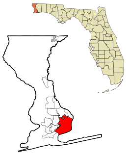
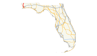
Escambia County is the westernmost and oldest county in the U.S. state of Florida, located in the northwestern corner of the state. At the 2010 census, the population is 297,619. Its county seat and largest city is Pensacola.

Escambia County is a county located in the south central portion of the U.S. state of Alabama. As of the 2010 census, the population was 38,319. Its county seat is Brewton.

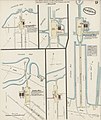
Century is a town in Escambia County, Florida, United States. The population was 1,698 at the 2010 United States Census. It is part of the Pensacola–Ferry Pass–Brent Metropolitan Statistical Area.
Pensacola is the westernmost city in the Florida Panhandle, and the county seat of Escambia County, Florida. As of 2019, the population was estimated to be 52,975. Pensacola is the principal city of the Pensacola Metropolitan Area, which had an estimated 502,629 residents as of 2019. Pensacola is one of the largest metropolitan areas in the Gulf Coast region.

The Florida Panhandle is the northwestern part of the U.S. state of Florida; it is a strip of land roughly 200 miles (320 km) long and 50 to 100 miles wide, lying between Alabama on the north and the west, Georgia on the north, and the Gulf of Mexico to the south. Its eastern boundary is arbitrarily defined. In terms of population, major communities include Tallahassee, Pensacola, and Navarre.

The Alabama and Gulf Coast Railway is a Class II railroad owned by Genesee & Wyoming. It operates 348 miles (560 km) of track from the Pensacola, Florida export terminals, west of downtown, north to Columbus, Mississippi, with trackage rights along BNSF Railway to Amory, Mississippi. A branch uses trackage rights along Norfolk Southern from Kimbrough, Alabama west and south to Mobile, Alabama, with separate trackage at the end of the line in Mobile.

Muscogee is a ghost town located twenty miles northwest of Pensacola, Florida, United States, in Escambia County, along the Perdido River. Named after the Muscogee Lumber Company, formed by Georgia lumber men, the European-American town was founded in 1857 by a group of lumbermen to harvest timber from the surrounding pine forests. They and the following company clearcut the timber, and once the forests were gone, lumbering ended in this area.

Perdido Key is an unincorporated community in Escambia County, Florida, United States, between Pensacola, Florida and Orange Beach, Alabama. "Perdido" means "lost" in the Spanish and Portuguese languages. The community is located on and named for Perdido Key, a barrier island in northwest Florida and southeast Alabama. The Florida district of the Gulf Islands National Seashore includes the east end of the island, as well as other Florida islands. No more than a few hundred yards wide in most places, Perdido Key stretches some 16 miles (26 km) from near Pensacola to Perdido Pass Bridge near Orange Beach.

Cantonment is a town in Escambia County, Florida. It is a suburb of Pensacola, and is located in the Pensacola metropolitan Area. Cantonment is located north of Gonzalez, and south of Molino. It is centered around U.S. Route 29, and extends to the Perdido River to the west, and the Escambia River to the east.

The Pensacola metropolitan area is the metropolitan area centered on Pensacola, Florida. It is also known as the Pensacola-Ferry Pass-Brent Metropolitan Statistical Area, a metropolitan statistical area (MSA) used for statistical purposes by the United States Census Bureau and other agencies. The Pensacola Standard Metropolitan Statistical Area was first defined after the 1960 United States Census, with Pensacola as the principal city, and included Escambia and Santa Rosa counties. Ferry Pass and Brent, which are unincorporated census-designated places in Escambia County, were added as principal cities after the 2000 Census. The population of the MSA in the 2010 census was 448,991. The estimated population of the MSA was 502,629 in 2019.
State Road 173, locally known as Blue Angel Parkway, is a major thoroughfare in the Pensacola, Florida metropolitan area. SR 173 has its southern terminus at the western entrance to NAS Pensacola, and runs south–north through West Pensacola to its northern terminus at State Road 297.
The history of Pensacola, Florida, begins long before the Spanish claimed founding of the modern city in 1698. The area around present-day Pensacola was inhabited by Native American peoples thousands of years before the historical era.
Interstate 10 (I-10) is a part of the Interstate Highway System that runs from Santa Monica, California, to Jacksonville, Florida. In Alabama, the Interstate Highway runs 66.269 miles (106.650 km) from the Mississippi state line near Grand Bay east to the Florida state line at the Perdido River. I-10 is the primary east–west highway of the Gulf Coast region of Alabama. The highway connects Mobile, the largest city in South Alabama, with Pascagoula, Mississippi, to the west and Pensacola, Florida, to the east. Within the state, the highway connects Mobile and Mobile County with the Baldwin County communities of Daphne and Fairhope. I-10 connects Mobile and Baldwin County by crossing the northern end of Mobile Bay and the southern end of the Mobile-Tensaw River Delta via the George Wallace Tunnel in Mobile and the Jubilee Parkway viaduct system between Mobile and Daphne.
U.S. Route 29 in the State of Florida is the westernmost south-to-north U.S. route in the state. It runs 43.6 miles (70.2 km) from downtown Pensacola north to the Alabama state line entirely within Escambia County. US 29 runs as a four-lane highway through much of the panhandle, becoming six lanes through and near several towns. The highway's hidden state road designation is entirely State Road 95.
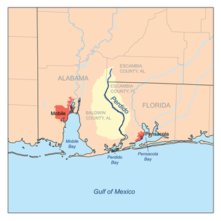
Perdido Bay is a bay at the mouth of and draining the Perdido River, a designated Outstanding Florida Waters river, in Baldwin County, Alabama and Escambia County, Florida, United States. It is essentially a coastal lagoon enclosed by barrier islands, with an inlet, Perdido Pass.
State Road 298, known locally as Lillian Highway, is a mostly east–west thoroughfare in Pensacola, Florida. It runs from its intersection with U.S. Highway 98 and Dog Track Road, skirting Perdido Bay on its way east to its terminus at the West Pensacola spur of SR 295. SR 298 passes under the mainline of SR 295 without an interchange. It serves as a major route through the communities of Myrtle Grove and West Pensacola.
State Road 97 is a south-north two-lane highway entirely in Escambia County, Florida. It runs from County Road 95A, just southeast of U.S. Highway 29 in Molino, to the Alabama state line near Atmore, where it becomes State Route 21. The road runs through the community of Walnut Hill and serves primarily to connect Pensacola to the northwest Escambia County and Atmore areas. In combination with SR 21, the road also provides a connection to Interstate 65.
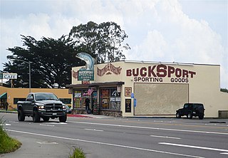
Bucksport was a town in Humboldt County, California. The original location was 2.5 miles (4 km) southwest of downtown Eureka, on Humboldt Bay about 5 miles (8 km) northeast of entrance. at an elevation of 16 feet (4.9 m). Prior to American settlement a Wiyot village named Kucuwalik stood here.

Andersonia is an unincorporated community in Mendocino County, California. It is located near U.S. Route 101 on the South Fork of the Eel River 1 mile (1.6 km) north-northwest of Piercy, at an elevation of 541 feet.

Foshee is an unincorporated community in Escambia County, Alabama, United States between Brewton and Pollard on U.S. Route 29. Foshee was founded as a sawmill town and named after Stewart J. Foshee, who owned several sawmills in Escambia County. Russell A. Alger and Martin Sullivan founded the Alger-Sullivan Lumber Company in the late 1890s and began logging around Foshee. They used lumber from the mill to build a new sawmill in Florida, which eventually grew into the town of Century. A post office was operated in Foshee from 1914 to 1924.