
The River Etherow is a river in northern England, and a tributary of the River Goyt. Although now passing through South Yorkshire, Derbyshire and Greater Manchester, it historically formed the ancient county boundary between Cheshire and Derbyshire. The upper valley is known as Longdendale. The river has a watershed of approximately 30 square miles (78 km2), and the area an annual rainfall of 52.5 inches (1,330 mm).

For the river in the West Midlands, see River Tame, West Midlands.

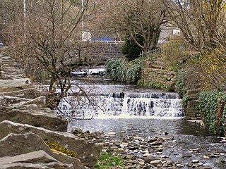
The River Colne in West Yorkshire is formed at the confluence of two brooks that originate in the Pennines close to Marsden. It flows in an easterly direction through the Colne Valley and Huddersfield towards Cooper Bridge where it flows into the River Calder.

Shaw and Crompton is a civil parish in the Metropolitan Borough of Oldham, Greater Manchester, England, which contains the town of Shaw and lies on the River Beal at the foothills of the South Pennines. It is located 2.3 miles (3.7 km) north of Oldham, 3.6 miles (5.8 km) south-east of Rochdale and 8.7 miles (14 km) north-east of Manchester.

The West Pennine Moors is an area of the Pennines covering approximately 90 square miles (230 km2) of moorland and reservoirs in Lancashire and Greater Manchester, England. It is a Site of Special Scientific Interest.

The River Roddlesworth is a river in Lancashire, England, a tributary of the River Darwen.

Eagley Brook is a small river of Lancashire and Greater Manchester in England.

Dean Brook is a river in Smithills, Bolton, Greater Manchester, historically within Lancashire.

Bradshaw Brook is a river draining parts of Lancashire and Greater Manchester in Northern England.

Pendleton Brook is a small river in Lancashire. The brook rises on Pendleton Moor and flows through the village of Pendleton, travelling north west to Higher Standen, then west past Standen Hall. From there, Pendleton Brook flows south of Clitheroe before meeting the River Ribble near Siddows.

Crompton Moor is an area of moorland in the South Pennines, in North West England. It lies along the northeastern outskirts of Shaw and Crompton, in the Metropolitan Borough of Oldham, Greater Manchester.

Bashall Brook is a minor river in Lancashire, England. It is 7.09 miles (11.41 km) long and has a catchment area of 6.86 square miles (1,777.68 ha).

Piethorne Brook is a watercourse in Greater Manchester. It is a tributary of the River Beal.

Old Brook is a small watercourse in Shaw and Crompton in the Metropolitan Borough of Oldham, Greater Manchester in the northwest of England. It flows from Crow Knowl on Crompton Moor to the River Beal. Its main feature is a waterfall at Pingot Quarry.
Whitewell Brook is a minor river in Lancashire, England. It is 4.34 miles (6.99 km) long and has a catchment area of 7.67 square miles (19.86 km2).

The Peak District Boundary Walk is a circular 190-mile (310 km) walking trail, starting and finishing at Buxton and broadly following the boundary of the Peak District, Britain's first national park. The route was developed by the Friends of the Peak District and was launched on 17 June 2017.

Greenfield Valley is a river valley through Saddleworth Moor in England's Peak District National Park. Historically this area of the South Pennines was part of Yorkshire but since 1974 it has been within the eastern edge of the county of Greater Manchester.

