Crompton Moor

Last updated

Crompton Moor
Crompton Moor.jpg
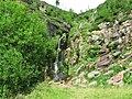
Crompton Moor towards its summit at Crow Knowl
Highest point
Elevation 391 m (1,283 ft)
Coordinates 53°35′27.82″N2°03′42.84″W / 53.5910611°N 2.0619000°W / 53.5910611; -2.0619000 Coordinates: 53°35′27.82″N2°03′42.84″W / 53.5910611°N 2.0619000°W / 53.5910611; -2.0619000
Geography
Greater Manchester UK relief location map.jpg
Red triangle with thick white border.svg
Crompton Moor
Location of Crompton Moor in Greater Manchester
Location Shaw and Crompton,
Greater Manchester,
England
Parent range South Pennines
OS grid SD960105
Geology
Mountain type Commons, Site of Biological Interest
Climbing
Easiest route Crompton Way

Crompton Moor (archaically known as High Moor [1] ) is an area of moorland in the South Pennines, in North West England. It lies along the northeastern outskirts of Shaw and Crompton, in the Metropolitan Borough of Oldham, Greater Manchester.

Contents

Spanning approximately 160 acres (65 ha), and reaching an elevation of 1,282 feet (391 m) at Crow Knowl, Crompton Moor is one of the largest open spaces run by Oldham Countryside Service. [2] It is a registered common of Greater Manchester, [3] and a Site of Biological Importance since 2003.

The Friends of Crompton Moor [4] are an active conservation group, who work in partnership with Oldham Countryside Service to maintain and protect this locally unique environment.

Most of Crompton Moor is covered in purple moor grass and heather, but there is also a significant amount of pine forest. [2] Wildlife on the moors includes red grouse, golden plover, and the meadow pipit. [2]

An early type of axe known as a palstave has been discovered on Crompton Moor, providing evidence of Bronze Age human activity. [5] During the 18th century Crompton Moor had several farms; dry stone walls still exist from these times as evidence of field division for pasture.

Crow Knowl, at the summit of Crompton Moor, features a transmitter station, Crow Knowl Telecommunications mast, and an Ordnance Survey triangulation station (at grid reference SD960105). Crow Knowl overlooks Rochdale to the northwest, Manchester to the southwest and Denshaw to the east, amongst other parts of Greater Manchester. [6]

Crompton Moor has been the site of several wildfires. A significant fire occurred in 1995, raging for over two weeks and burning a large proportion of the surface vegetation as well as the subsurface peat. Another took place in March 2007.

Brushes Clough and Pingot are former coal and sandstone quarries on Crompton Moor. [7] During the 1970s, quarrying was halted, the land was reclaimed, and thousands of pine trees were planted. The area has since been used for recreation, including hiking, orienteering, cycling and horse riding. [2] [7] Brushes Clough Reservoir was constructed in the 19th century by the Oldham County Borough Council, [8] using stone quarried from this site. After being managed by United Utilities for a number of years, the reservoir and some of the surrounding land is now privately owned. [7]

An unnamed waterfall (provisionally called Crompton Waterfall) cascades off Crompton Moor into the now unused Pingot Quarry forming the Old Brook, a tributary of the River Beal. [2] [7] [9]

Related Research Articles

<span class="mw-page-title-main">Greenfield, Greater Manchester</span> Human settlement in England

Greenfield is a village in the civil parish of Saddleworth in the Metropolitan Borough of Oldham, in Greater Manchester, England. It is 4 miles (6.4 km) east of Oldham, and 13 miles (21 km) northeast of Manchester. It lies in a broad rural area at the southern edge of the South Pennines. To the east of the village Dovestone Reservoir, Chew Reservoir and Greenfield Reservoir lie in the Peak District National Park.

<span class="mw-page-title-main">Shaw and Crompton</span> Civil parish in Greater Manchester, England

Shaw and Crompton is a civil parish in the Metropolitan Borough of Oldham, Greater Manchester, England, which contains the town of Shaw and lies on the River Beal at the foothills of the South Pennines. It is located 2.3 miles (3.7 km) north of Oldham, 3.6 miles (5.8 km) south-east of Rochdale and 8.7 miles (14 km) north-east of Manchester.

<span class="mw-page-title-main">West Pennine Moors</span>

The West Pennine Moors is an area of the Pennines covering approximately 90 square miles (230 km2) of moorland and reservoirs in Lancashire and Greater Manchester, England. It is a Site of Special Scientific Interest.

<span class="mw-page-title-main">Geography of Greater Manchester</span>

The geography of Greater Manchester is dominated by one of the United Kingdom's largest metropolitan areas, and in this capacity the landlocked metropolitan county constitutes one of the most urbanised and densely populated areas of the country. There is a mix of high density urban areas, suburbs, semi-rural and rural locations in Greater Manchester, but overwhelmingly the land use in the county is urban.

<span class="mw-page-title-main">Drinkwater Park</span>

Drinkwater Park is situated in the Irwell Valley on the western border of Prestwich, near Manchester, bounded by the River Irwell to the west, Agecroft Road and Rainsough Brow (A6044) to the south, Butterstile Lane and Carr Clough estate to the east and Bunkers Hill to the north. The park is administered by Forestry England and is part of Prestwich Forest Park, which also incorporates Philips Park, Mere Clough, Prestwich Clough, Forest Bank Park in Pendlebury and Waterdale Meadow.

<span class="mw-page-title-main">Piethorne Brook</span> Stream in Greater Manchester, England

Piethorne Brook is a watercourse in Greater Manchester. It is a tributary of the River Beal.

<span class="mw-page-title-main">Old Brook (England)</span> Watercourse in Greater Manchester

Old Brook is a small watercourse in Shaw and Crompton in the Metropolitan Borough of Oldham, Greater Manchester in the northwest of England. It flows from Crow Knowl on Crompton Moor to the River Beal. Its main feature is a waterfall at Pingot Quarry.

<span class="mw-page-title-main">Brushes Clough Reservoir</span> Body of water

Brushes Clough Reservoir is on Crompton Moor in Shaw and Crompton, Greater Manchester, England. It was created in the 19th century by the damming of Leornardin Brook. The outlet of the reservoir flows through Brushes Clough to merge with Old Brook, a tributary of the River Beal.

<span class="mw-page-title-main">Denshaw</span> Village in Saddleworth, Greater Manchester

Denshaw is a village in the civil parish of Saddleworth in the Metropolitan Borough of Oldham, in Greater Manchester, England. It lies by the source of the River Tame, high amongst the Pennines above the village of Delph, 4.6 miles (7.4 km) northeast of Oldham,3.3 miles (5.3 km) north-northwest of Uppermill and Shaw and Crompton. It has a population of around 500.

<span class="mw-page-title-main">Trent Mill</span> Cotton mill in Greater Manchester, England

Trent Mill was a cotton spinning mill on Duchess Street in Shaw and Crompton, Greater Manchester, England. It was built by F.W. Dixon & Son in 1908. It closed and was taken over by the Lancashire Cotton Corporation in 1929 reopened in 1938 and closed again in 1962, and was demolished in 1967.

<span class="mw-page-title-main">Rutland Mill</span> Cotton mill in Greater Manchester, England

Rutland Mill was a cotton spinning mill on Linney Lane, in Shaw and Crompton, Greater Manchester, England. It was built by F. W. Dixon & Son in 1907 for the Rutland Mill Co. Ltd. It was taken over by the Lancashire Cotton Corporation in 1935. By 1964, it was in the Courtaulds Group. In the late 1980s, as Courtaulds moved operations to other parts of the world, the mill was bought by Littlewoods who demolished it and replaced it with a new automated storage warehouse.

<span class="mw-page-title-main">Hawk Mill, Shaw</span> Cotton mill in Greater Manchester, England

Hawk Mill, Shaw was a cotton spinning mill in Shaw, Oldham, Greater Manchester. It was built in 1908. It was taken over by the Lancashire Cotton Corporation in the 1931 and passed to Courtaulds in 1964. The mill closed in 1967, and was demolished in 1991.

<span class="mw-page-title-main">Dawn Mill, Shaw</span> Cotton mill in Greater Manchester, England

Dawn Mill, Shaw was a cotton spinning mill in Shaw and Crompton, Oldham, Greater Manchester. It was built on the site of Shaw Mill at the "dawn" of the 20th century. Dawn Mill was equipped with mule weft spindles in 1950. It was powered by Engines named Venus and Mars, 1800 hp twin tandem compound engine by George Saxon of Manchester. It was taken over by the Lancashire Cotton Corporation in the 1930s and passed to Courtaulds in 1964. It was sold again and used by distribution company DTS Logistics for storing and distributing clothing. It was demolished in 2006 to make way for an Asda supermarket.

<span class="mw-page-title-main">Newby Mill, Shaw</span> Cotton mill in Greater Manchester, England

Elm Mill, was a four-storey cotton spinning mill in Shaw and Crompton, Greater Manchester, England. It was built in 1890 for the Elm Spinning Company Ltd., and was called Elm Mill until it closed in 1928. It was revived by the Lancashire Cotton Corporation in 1929 and called Newby Mill. LCC and all their assets passed to Courtaulds in 1964. Production at Newby finished in 1970, and it was used for warehousing. Subsequently, named Shaw No 3 Mill, it became part of Littlewood's Shaw National Distribution Centre. It was demolished to make way for housing in 2022.

<span class="mw-page-title-main">Peak District Boundary Walk</span> Long distance footpath in England

The Peak District Boundary Walk is a circular 190-mile (310 km) walking trail, starting and finishing at Buxton and broadly following the boundary of the Peak District, Britain's first national park. The route was developed by the Friends of the Peak District and was launched on 17 June 2017.

<span class="mw-page-title-main">Greenfield Valley</span> Valley at Saddleworth Moor in the Peak District

Greenfield Valley is a river valley through Saddleworth Moor in England's Peak District National Park. Historically this area of the South Pennines was part of Yorkshire but since 1974 it has been within the eastern edge of the county of Greater Manchester.

References

  1. Rathbone, Peter (2000). The Lives of the People of Crompton, Lancashire 1580–1700. Lancashire and Cheshire Antiquarian Society.
  2. 1 2 3 4 5 Steve Duthie (August 2007). "Moors to life". Fourmost magazine. HKR magazines. p. 18.
  3. "The Common Lands of Greater Manchester; A Biological Survey" (PDF). Rural Surveys Research Unit. Archived from the original (PDF) on 26 September 2007. Retrieved 13 August 2007.
  4. "Friends of Crompton Moor | …caring for a beautiful place".
  5. Historic England. "Monument No. 46038". Research records (formerly PastScape). Retrieved 1 August 2008.
  6. Clarke, Rogerson (2006). Walk the South Pennines. Discovery Walking Guides. p. 46. ISBN   1-904946-13-5.
  7. 1 2 3 4 "Crompton Moor Walking Trails" (PDF). oldham.gov.uk. 16 June 2003. Archived from the original (PDF) on 28 September 2007. Retrieved 20 June 2007.
  8. Crompton Urban District Council (1959), Crompton Urban District: Official Guide and Traders' Directory, Jones & Brooks, p. 19
  9. "Crompton Moor History Trail" (PDF). oldham.gov.uk. 16 June 2003. Archived from the original (PDF) on 28 September 2007. Retrieved 20 June 2007.