Brussels–Charleroi Canal

Last updated

Brussels–Charleroi Canal
Location Canal Brussel-Charleroi.PNG
The course of the Brussels–Charleroi Canal
Specifications
Length65 km (40 mi)
History
Construction began1827
Date completed1832
Geography
Start point Brussels, Belgium
End point Charleroi, Belgium

The Brussels–Charleroi Canal (French : Canal Bruxelles-Charleroi, Dutch : Kanaal Brussel-Charleroi), also known as the Charleroi Canal amongst other similar names, is an important canal in Belgium. The canal is quite large, with a Class IV Freycinet gauge, and its Walloon portion is 47.9 kilometres (29.8 mi) long. It runs from Charleroi (Wallonia) in the south to Brussels in the north.

Contents

The canal is part of a north–south axis of water transport in Belgium, whereby the north of France (via the Canal du Centre) including Lille and Dunkirk and important waterways in the south of Belgium including the Sambre valley and the sillon industriel are linked to the port of Antwerp in the north, via the Brussels–Scheldt Maritime Canal, which meets the Brussels–Charleroi Canal at the Sainctelette area of Brussels.

The Ronquières inclined plane is the canal's most remarkable feature and a tourist site. [1]

History

Early proposals

The idea of a waterway to serve the cities of Hainaut, linking them ultimately with Antwerp, was first put forward during the reign of Philip the Good, Duke of Burgundy (1396–1467). In 1436, an edict authorised the modification and deepening of the Senne river, though the project turned out to be more expensive than previously thought. The authorities of Mechelen, the sole city allowed to tax water transport on the Senne, protested extensively at the prospect of the construction of a parallel canal, and the project was abandoned.

During the 16th century, the prospect of a canal was renewed. In 1531, Emperor Charles V authorised the construction of a canal linking Charleroi and Willebroek, though work did not begin immediately. It was not until 1550 that Mary of Habsburg, Governor of the Netherlands, finally ordered work to begin. When work was finished in 1561, the canal linked Brussels to the Rupel river at Willebroek, though it did not continue south past Brussels.

As part of France from 1795 to 1815, proposals to build the canal were hampered by Napoleon's focus on waging expansionist wars.

Construction

During the Industrial Revolution, coal saw a tremendous rise in economic importance. The Sambre and Marne valleys are quite rich in coal, and during the reign of King William I of the Netherlands (1813–1840), concrete plans to extend the canal were at last made.

The project was undertaken by A. J. Barthélemy, member of the lower chamber of the States-General of the Netherlands and adviser to the regent in Brussels. He proposed inclined planes be used instead of locks, but his idea was ahead of its time. An inclined plane is quicker, and wastes less water, than a flight of canal locks, but is more costly to install and run. Jean-François Gendebien, a very prominent Belgian politician (although Belgium was then called the Southern Netherlands and was not independent) supported the idea, though finances had the last say in the matter, resulting in locks being chosen over inclined planes.

Today's canal is actually the fourth version. The first version, built from 1827 to 1832, has a gauge of only 70 tonnes (150,000 lb). Just over 20 years later, in 1854, work began to create a "large gauge" canal (today's medium gauge) of 300 tonnes (660,000 lb) on certain sections, which was completed in 1857. Ambitious enlargements began again with the lock at Flanders' Gate (French: Porte de Flandre, Dutch: Vlaamsepoort) in Brussels, which was expanded to a gauge of 600–800 tonnes (1,300,000–1,800,000 lb).

Later development

As Belgian industry began to flourish in the City of Brussels and its neighbouring municipalities, the land surrounding the canal became increasingly important and diverse. Two very prominent trade routes crossed paths in the valley of Brussels along the waterways, bringing in large numbers of merchants to lower Brussels. One of the major trade routes was from the Rhineland to Flanders, while the other one was from Antwerp to the industrial zone of Hainaut. [2] This area along the water was a booming marketplace crucial to the up-rise of urbanisation, and in turn to the modernisation of Brussels and the other cities connected by the canal. [3]

After a first period of rapid industrialisation that had taken place sometime between the 1750s and 1780s, the opening of the canal greatly increased the traffic of coal and thus the mechanisation of industry, which led to the development of foundries, engineering and metalworking companies. [4] Because of this, life around the canal expanded at very high rates. The canal was state of the art; the connection of waterways and roads allowed this area to become a centre of activity. The growth of international and domestic trade coupled with an increase in capital investment from wealthy landowners and merchants produced tons of jobs in the canal area. [3] The growth of the community continued unabated throughout the 19th century, leading to cramped living conditions near the canal.

After this, Brussels showed no signs of slowing down on its journey to becoming one of the most influential cities in all of Europe. [3] By 1930, Brussels population was up to over 200,000, compared to an estimated 65,000 in 1700. [2] During the early 1980s, the 25 neighbourhoods around the canal were home to one fifth of Brussels' population. The surrounding area holds a sense of youth, as it contributes to Brussels having the youngest population of any city in Belgium. The effects of this mass migration to the lower valley in Brussels can be seen in the diversity of cultures. [5] As the trade economy along the waterways continued to grow and attracted by the industrial opportunities, many workers moved in, first from the other Belgian provinces (mainly rural residents from Flanders) [6] and France, then from Southern European, and more recently from Eastern European and African countries. It has been estimated that the population of immigrants grew from 7% of the total population in the early 1960s to 56% of the total population in the early 2000s. [2]

By 1933, all locks downstream of Clabecq were modified to a capacity of 1,350 tonnes (2,980,000 lb). The last major improvement to the canal was the addition, in 1968, of the Class IV, 1350 tonne inclined plane at Ronquières, just uphill of Lock #5 at Ittre. The inclined plane is considered a masterpiece of civil engineering, while the lock has a rise of 13.5 m (44 ft), one of the highest in Belgium. [1]

Recent history

On 17 December 2005, the body of the former Rwandan cabinet minister Juvénal Uwilingiyimana was found in the canal. He had gone missing on 21 November 2005, and when his body was found, it was naked and badly decomposed. [7] Uwilingiyimana had been indicted by the International Criminal Tribunal for Rwanda for his participation in the 1994 Rwandan genocide. He had been meeting with ICTR officials, and many thought he was to testify against high-ranking officials from the former Hutu regime. [7]

Ronquières inclined plane

The Ronquieres inclined plane, the canal's most remarkable feature Ronquieres JPG01.jpg
The Ronquières inclined plane, the canal's most remarkable feature

The Ronquières inclined plane has a length of 1,432 m (1,566 yd) and lifts boats through 68 m (223 ft) vertically. [8] [9] It consists of two large caissons mounted on rails. Each caisson measures 91 m (299 ft) long by 12 m (39 ft) wide and has a water depth between 3 and 3.7 m (9.8 and 12.1 ft). It can carry one boat of 1,350 tonnes or many smaller boats within the same limits.

The weight of each caisson is held by a counterweight of 5,200 tonnes (11,500,000 lb) that runs beneath the rails. [8] Eight cables per caisson running around winches at the top allow each caisson to be moved independently of the other. They can be moved between the two canal levels at a speed of 1.3 m/s (4 ft/s), boats taking 50 minutes in total to pass through the entire structure. [8]

The inclined plane, while still in use, is now being promoted as a tourist site. [1]

Traffic

Related Research Articles

<span class="mw-page-title-main">Transport in Belgium</span>

Transport in Belgium is facilitated with well-developed road, air, rail and water networks. The rail network has 2,950 km (1,830 mi) of electrified tracks. There are 118,414 km (73,579 mi) of roads, among which there are 1,747 km (1,086 mi) of motorways, 13,892 km (8,632 mi) of main roads and 102,775 km (63,861 mi) of other paved roads. There is also a well-developed urban rail network in Brussels, Antwerp, Ghent and Charleroi. The ports of Antwerp and Bruges-Zeebrugge are two of the biggest seaports in Europe. Brussels Airport is Belgium's biggest airport.

<span class="mw-page-title-main">Scheldt</span> River in France, Belgium and the Netherlands

The Scheldt is a 435-kilometre-long (270 mi) river that flows through northern France, western Belgium, and the southwestern part of the Netherlands, with its mouth at the North Sea. Its name is derived from an adjective corresponding to Old English sceald ("shallow"), Modern English shoal, Low German schol, West Frisian skol, and obsolete Swedish skäll ("thin").

<span class="mw-page-title-main">Lock (water navigation)</span> Device for raising and lowering boats or ships

A lock is a device used for raising and lowering boats, ships and other watercraft between stretches of water of different levels on river and canal waterways. The distinguishing feature of a lock is a fixed chamber in which the water level can be varied; whereas in a caisson lock, a boat lift, or on a canal inclined plane, it is the chamber itself that rises and falls.

<span class="mw-page-title-main">Anderton Boat Lift</span> Two caisson lift lock near Anderton, Cheshire, England

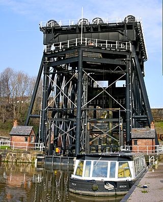
The Anderton Boat Lift is a two-caisson lift lock near the village of Anderton, Cheshire, in North West England. It provides a 50-foot (15.2 m) vertical link between two navigable waterways: the River Weaver and the Trent and Mersey Canal. The structure is designated as a scheduled monument, and is included in the National Heritage List for England; it is also known as one of the Seven Wonders of the Waterways.

<span class="mw-page-title-main">Sambre–Oise Canal</span>

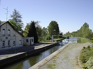
The Canal de la Sambre à l'Oise is a canal in northern France. It forms a connection between the canalised river Sambre at Landrecies and the Oise at La Fère. The canal is 71 kilometres (44 mi) long, and has 38 locks. The junction made at La Fère is with a branch of the Canal de Saint-Quentin, while the Canal latéral à l'Oise is joined 10.5 km further downstream at Chauny. It was used by the standard Freycinet-gauge péniches, 38.50 metres (126.3 ft) long, and 5.05 metres (16.6 ft) in beam, carrying up to 250 tonnes. The canal, also a popular waterway for boats heading south from the Netherlands and Belgium to the central French waterways, had to be closed in 2006 when two aqueducts were found to be in danger of failing. Funding has been put in place by the owner, Voies Navigables de France, and the local authorities, with support from the State. The canal was reopened in July 2021.

<span class="mw-page-title-main">Canal inclined plane</span> Cable railway for changing boat elevation

An inclined plane is a type of cable railway used on some canals for raising boats between different water levels. Boats may be conveyed afloat, in caissons, or may be carried in cradles or slings.

<span class="mw-page-title-main">Foxton Inclined Plane</span> Canal inclined plane in Leicestershire, England

The Foxton Inclined Plane is a canal inclined plane on the Leicester line of the Grand Union Canal about 5 km (3.1 mi) west of the Leicestershire town of Market Harborough, named after the nearby village of Foxton. The plane was built in 1900 as a solution to various operational restrictions imposed by the Foxton Lock flight. However, it was not a commercial success and only remained in full-time operation for ten years. The plane was dismantled in 1926. A project to re-create the plane commenced in the 2000s because the narrowbeam locks remain a bottleneck for leisure boat traffic.

<span class="mw-page-title-main">Boat lift</span> Machine to move boats vertically between waterways

A boat lift, ship lift, or lift lock is a machine for transporting boats between water at two different elevations, and is an alternative to the canal lock.

<span class="mw-page-title-main">Sambre</span> River in France and Belgium

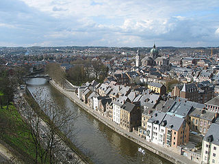
The Sambre is a river in northern France and in Wallonia, Belgium. It is a left-bank tributary of the Meuse, which it joins in the Wallonian capital Namur.

<span class="mw-page-title-main">Monkland Canal</span>

The Monkland Canal was a 12+14-mile-long (19.7 km) canal designed to bring coal from the mining areas of Monklands to Glasgow in Scotland. In the course of a long and difficult construction process, it was opened progressively as short sections were completed, from 1771. It reached Gartcraig in 1782, and in 1794 it reached its full originally planned extent, from pits at Calderbank to a basin at Townhead in Glasgow; at first this was in two sections with a 96-foot (29 m) vertical interval between them at Blackhill; coal was unloaded and carted to the lower section and loaded onto a fresh barge. Locks were later constructed linking the two sections, and the canal was also connected to the Forth and Clyde Canal, giving additional business potential.

<span class="mw-page-title-main">Elbląg Canal</span>

Elbląg Canal is a canal in Poland, in Warmian-Masurian Voivodeship, 80.5 kilometres (50.0 mi) in length, which runs southward from Lake Drużno, to the river Drwęca and lake Jeziorak. It can accommodate small vessels up to 50 tonnes displacement. The difference in water levels approaches 100 metres (330 ft), and is overcome using locks and a system of inclined planes between lakes.

<span class="mw-page-title-main">Strépy-Thieu boat lift</span> Architectural structure, Belgium

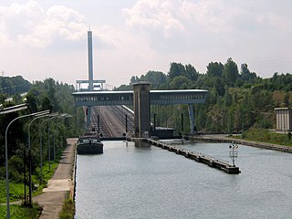
The Strépy-Thieu boat lift lies on a branch of the Canal du Centre in the municipality of Le Rœulx, Hainaut, Belgium. With a height difference of 73.15 metres (240.0 ft) between the upstream and downstream reaches, it was the tallest boat lift in the world upon its completion, and remained so until the Three Gorges Dam ship lift in China was completed in January 2016.

<span class="mw-page-title-main">Canal du Centre (Belgium)</span> Canal in Belgium

The Canal du Centre is a canal in Wallonia, Belgium, which, with other canals, links the waterways of the Meuse and Scheldt rivers. It has a total length of 20.9 km. It connects the artificial lake Grand Large near Nimy, with the Brussels–Charleroi Canal near Seneffe.

<span class="mw-page-title-main">Caisson lock</span> Type of canal lock

The caisson lock is a type of canal lock in which a narrowboat is floated into a sealed watertight box and raised or lowered between two different canal water levels. It was invented in the late 18th century as a solution to the problem posed by the excessive demand for water when conventional locks were used to raise and lower canal boats through large height differences. Such locks, each of which would only raise and lower boats through small height differences of a few feet, would not suffice when large height differences had to be tackled nor when water was in short supply. The caisson was thought to be one solution, although it transpired that the technology of the day was not capable of achieving this type of construction economically.

<span class="mw-page-title-main">Saint-Louis-Arzviller inclined plane</span>

The Saint-Louis-Arzviller inclined plane is an inclined plane on the Marne-Rhine Canal that enables the canal to cross the Vosges Mountains. It is located in the commune of Saint-Louis, between the towns of Saint-Louis and Arzviller in the département of the Moselle.

<span class="mw-page-title-main">Ronquières inclined plane</span>

The Ronquières Inclined Plane is a Belgian canal inclined plane on the Brussels-Charleroi Canal in the province of Hainaut in Wallonia that opened in April 1968 after six years of construction. It is in the municipality of Braine-le-Comte and takes its name from the nearby village of Ronquières.

<span class="mw-page-title-main">Brussels–Scheldt Maritime Canal</span> Canal in Belgium

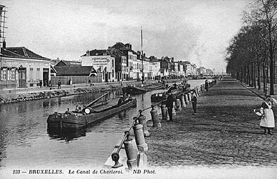
The Brussels–Scheldt Maritime Canal, also known as the Willebroek Canal amongst other similar names, is an important canal in Belgium. The 28-kilometre-long (17 mi) canal has a width of 30 metres (98 ft) and a draught of 2 metres, and connects Brussels with the Scheldt river at Wintam and ultimately the sea.

<span class="mw-page-title-main">Brussels Canal</span> Canal in Brussels, Belgium

The Brussels Canal is a section of waterway in Brussels, Belgium. It generally refers to the northernmost portion of the Brussels–Charleroi Canal and the southernmost section of the Brussels–Scheldt Maritime Canal or Willebroek Canal.

<span class="mw-page-title-main">Port of Brussels</span> Port in Brussels, Belgium

The Port of Brussels is an inland port at a distance of 120 kilometres (75 mi) from the sea. It is accessible for ships up to 4,500 tonnes and push towing convoys up to 9,000 tonnes. Via the Brussels–Scheldt Maritime Canal even sea-going vessels can reach the outer port, and through the Brussels–Charleroi Canal the transit to Wallonia is assured. The port is located in the City of Brussels in the Brussels-Capital Region.

References

Notes

  1. 1 2 3 "Plan incliné de Ronquières" (in French). Association pour la Gestion et l'Exploitation touristiques et sportives des Voies d'Eau du Hainaut. 25 September 2007. Retrieved 5 October 2007.
  2. 1 2 3 State, Paul, F (2015). "Historical Dictionary of Brussels". Rowman and Littlefield Publishers: 491.{{cite journal}}: CS1 maint: multiple names: authors list (link)
  3. 1 2 3 Polasky 1987, p. 19–23.
  4. Charruadas 2005.
  5. Vermeulen, Sofie (2015). The Brussels Canal Zone : Negotiating visions for urban planning. ASP. pp. 77–78.
  6. Buron 2016, p. 80–82.
  7. 1 2 "Canal body 'was Rwandan minister'". BBC News . 23 December 2005. Retrieved 5 October 2007.
  8. 1 2 3 "The inclined plane of Ronquières". Direction générale des services techniques [of Wallonia]. Archived from the original on 11 June 2008. Retrieved 6 October 2007.
  9. Permanent International Association of Navigation Congresses. (1989). Ship lifts: report of a Study Commission within the framework of Permanent ... PIANC. ISBN   978-2-87223-006-8 . Retrieved 14 December 2011.

Bibliography

50°36′31″N4°13′28″E / 50.6087°N 4.2244°E / 50.6087; 4.2244