Bruton Dovecote

Last updated

Bruton Dovecote
Bruton Somerset Dovecote.jpg
Location Bruton, Somerset, England
Coordinates 51°06′29″N2°27′11″W / 51.10806°N 2.45306°W / 51.10806; -2.45306 Coordinates: 51°06′29″N2°27′11″W / 51.10806°N 2.45306°W / 51.10806; -2.45306
Area6 square metres (65 sq ft)
Built16th or 17th century
Owner National Trust
Listed Building – Grade II*
Official nameDovecote about 370 metres South of Bruton Church (also known as Pigeon Tower)
Designated24 March 1961 [1]
Reference no.1056424
Official nameProspect tower 230 m south of King's School
Designated14 February 1953 [2]
Reference no.1019895
Somerset UK location map.svg
Red pog.svg
Location of Bruton Dovecote in Somerset

The Bruton Dovecote is a limestone tower that was built between the 15th and 17th century in Bruton in the English county of Somerset. The structure was once used as a dovecote, and may have been a watchtower or prospect tower prior to this. It is a Grade II* listed building [1] and scheduled monument. [2] [3] [4]

Contents

It has been associated with Bruton Abbey and the Berkley family who owned the estate after the dissolution. It is known that the conversion to house pigeons and doves took place around 1780. It was acquired by the National Trust in 1915 and they have managed the site since then undertaking restoration work.

History

Though the Bruton Dovecote's date of construction is not known precisely, the structure was built some time between the 15th and 17th century. [2] Architectural historian Lydia Greeves suggests that the building was once within the deerpark of Bruton Abbey and was adapted by the monks from a gabled Tudor tower. [5] However, John and Pamela McCann, authors of The Dovecotes of Historical Somerset, claim that the structure was not built until after the Dissolution of the Monasteries in the 1530s. The authors claim that the Berkley family, who acquired the lands of the Abbey, constructed the building as a prospect tower. [6] Dendrochronological dating commissioned by the National Trust found that timber in the door and window frames came from trees felled between 1554 and 1586. [7]

The conversion to be a dovecote took place around 1780. [8] Pigeons and doves were an important food source historically kept for their eggs, flesh, and dung. [9] Although it is now a roofless ruin with some of the windows blocked up, it previously had a chimney and the fireplace can still be seen. [1] The National Trust acquired the freehold from Sir Henry Hugh Arthur Hoare of the Hoare baronets, whose family seat was at Stourhead, in 1915. [10] The tower was subsequently designated as a scheduled monument in 1953 and a listed building (Grade II*) in 1961. [1] [2]

In the 1980s the dovecote was inspected as part of an investigation into an outbreak of psittacosis (also known as parrot disease or parrot fever), a zoonotic infectious disease caused by the bacterium Chlamydophila psittaci , at the adjoining King's School. No cause was found for the infection. [11] In 2010 restoration work was undertaken including repairs to the tops of the walls; these are exposed as the building no longer has a roof. Wall ties were used on the south west corner where the masonry was bulging. [12] In addition, car parking and educational signage was provided. This was partially funded by South Somerset council, Bruton Town Council and the Heritage Lottery Fund to a total of £105,000. [13] [14] [15]

Location

The dovecote stands on Lusty Hill to the south of Bruton overlooking the town. It is approximately 370 metres (1,210 ft) south of the Church of St Mary, [1] and 230 metres (750 ft) south of King's School. [2] It is on the Leland Trail. [16]

Architecture

The square tower was built of local coursed oolitic limestone with Doulting stone dressings. The walls are 2 feet 8 inches (0.81 m) thick at the base, [6] and the tower is 6 square metres (65 sq ft) in plan. [2] The doorway has an ovolo moulded arch which is 5 feet 9 inches (1.75 m) high. This suggests a construction date in the late 16th or early 17th century. Another entrance was made for cattle to enter at a later date but this has been blocked up. Several of the windows have also been filled with stone. [6] On the north-east face there were two-light chamfered mullioned windows on each floor while on the north-west wall they were one- and two-light windows. [1]

It has over 200 pigeon holes, which were installed after the original construction, possibly before 1780. [2] [17] [18] Six tiers of nest boxes remain; however there were previously several more, possibly as many as 850. They are made of regular blocks of tufa each around 8 inches (200 mm) square and 16 inches (410 mm) deep. [6]

See also

Related Research Articles

Dunster Human settlement in England

Dunster is a village, civil parish and former manor within the English county of Somerset, today just within the north-eastern boundary of the Exmoor National Park. It lies on the Bristol Channel coast 2.5 miles (4 km) south-southeast of Minehead and 20 miles (32 km) northwest of Taunton. The United Kingdom Census of 2011 recorded a parish population of 817.

Dovecote A structure built for the purposes of housing birds

A dovecote or dovecot, doocot (Scots) or columbarium is a structure intended to house pigeons or doves. Dovecotes may be free-standing structures in a variety of shapes, or built into the end of a house or barn. They generally contain pigeonholes for the birds to nest. Pigeons and doves were an important food source historically in the Middle East and Europe and were kept for their eggs and dung.

Brewham Human settlement in England

Brewham is a civil parish in Somerset, England, consisting of the villages of North Brewham and South Brewham, on either side of the river in the Brue Valley 3 miles (4.8 km) east of Bruton and 9 miles (14.5 km) south-west of Frome in the South Somerset district. The parish has a population of 441.

Bruton Town in Somerset, England

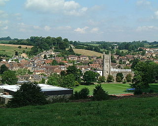
Bruton is a market town, electoral ward, and civil parish in Somerset, England, on the River Brue and the A359 between Frome and Yeovil. It is 7 miles south-east of Shepton Mallet, just south of Snakelake Hill and Coombe Hill, 10 miles north-west of Gillingham and 12 miles south-west of Frome in South Somerset district. The town and ward have a population of 2,907. The parish includes the hamlets of Wyke Champflower and Redlynch. Bruton has a museum of items from the Jurassic era onwards. It includes a table used by the author John Steinbeck on a six-month stay. The Brue is flood-prone – in 1768 it wrecked a stone bridge. The 242.8 mm of rain that fell on 28 June 1917 left a river watermark on a pub wall 20 feet above the mean. In 1984 a protective dam was built upstream.

Marksbury Human settlement in England

Marksbury is a small village and civil parish on the eastern edge of the affluent Chew Valley in Somerset, about 4 miles (6.4 km) from Keynsham and 7 miles (11.3 km) from Bath on the A39 where it meets the A368. The parish, which includes the villages of Hunstrete and Stanton Prior, has a population of 397.

Walton and Ivythorn Hills Hills in Somerset, England

Walton and Ivythorn Hills is a 34.9 hectares biological Site of Special Scientific Interest near Street at the south-eastern end of the Polden Hills in the English county of Somerset. Walton Hill is south of the village of Walton, and Ivythorn Hill is south of Street. Notified in 1953, the site is now owned and managed by the National Trust who acquired the freehold in 1988.

Evercreech Human settlement in England

Evercreech is a village and civil parish 3 miles (4.8 km) south east of Shepton Mallet, and 5 miles (8.0 km) north east of Castle Cary, in the Mendip district of Somerset, England. The parish includes the hamlet of Stoney Stratton and the village of Chesterblade.

West Pennard Human settlement in England

West Pennard is a village and civil parish east of Glastonbury, situated at the foot of Pennard Hill, in the Mendip district of Somerset, England. The parish includes the hamlets of Coxbridge and Woodlands.

Bruton Abbey

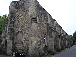
Bruton Abbey in Bruton, Somerset was founded as a house of Augustinian canons in about 1127, and became an abbey in 1511, shortly before its dissolution in 1539. It was endowed with manors, churches and other properties in the area and also in Normandy in France.

Lytes Cary Grade I listed house in Somerset, UK

Lytes Cary is a manor house with associated chapel and gardens near Charlton Mackrell and Somerton in Somerset, England. The property, owned by the National Trust, has parts dating to the 14th century, with other sections dating to the 15th, 16th, 18th, and 20th centuries. "Yet all parts blend to perfection with one another and with the gentle sunny landscape that surrounds them," comments Nikolaus Pevsner. The House is listed as Grade I by English Heritage.

West Pennard Court Barn Grade I listed building in Mendip, UK

West Pennard Court Barn is a late 14th or early 15th century tithe barn which was built for Glastonbury Abbey. The Grade I listed building is between West Pennard and West Bradley in the English county of Somerset.

Stoke sub Hamdon Priory Grade I listed building in Somerset, England

Stoke sub Hamdon Priory is a complex of buildings and ruins which initially formed a 14th-century college for the chantry chapel of St Nicholas, and later was the site of a farm in Stoke-sub-Hamdon, Somerset, England. The only building remaining from the college is a great hall and attached dwelling, dating from the late 15th century. The hall is designated by English Heritage as a Grade I listed building, while the outbuildings and gateway are Grade II listed. The whole site has been scheduled as an ancient monument. A number of the farm buildings are in poor condition, and have been added to the Heritage at Risk Register.

Grade I listed buildings in South Somerset

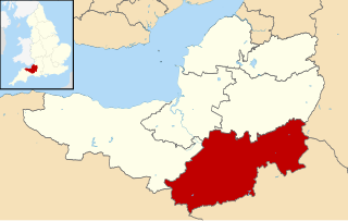
South Somerset is a local government district in the English county of Somerset. The South Somerset district occupies an area of 370 square miles (958 km2), stretching from its borders with Devon and Dorset to the edge of the Somerset Levels. The district has a population of about 158,000, and has Yeovil as its administrative centre.

St Marys Church, Bruton Church in Somerset, England

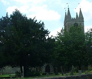
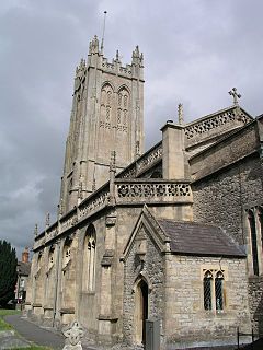
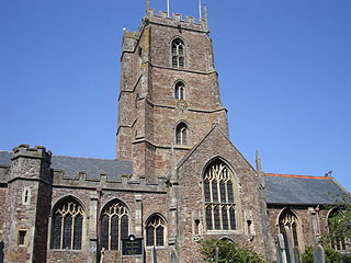
The Church of St Mary in Bruton, Somerset, England was largely built in the 14th century. Like many Somerset churches, it has a very fine tower; less usually it has a second one as well. Simon Jenkins has called Bruton's tower "Somerset architecture at its most powerful." It has been designated a Grade I listed building.

Dunster Priory

Dunster Priory was established as a Benedictine monastery around 1100 in Dunster, Somerset, England.

Church of St Peter and St Paul, Wincanton

The Anglican Church of St Peter and St Paul in Wincanton within the English county of Somerset is a Grade II* listed building. The Church of St Peter and St Paul was almost totally rebuilt 1887-91 by J. D. Sedding, however parts of the tower may be remnants form an earlier church, dating from 1313, on the same site.

Dovecot at Blackford Farm Grade II* listed building

The Dovecot At Blackford Farm in Selworthy on Exmoor within the English county of Somerset was probably built in the 11th century. It is a Grade II* listed building, and scheduled monument.

Scheduled monuments in Somerset Nationally important sites in Somerset, England

There are over 670 scheduled monuments in the ceremonial county of Somerset in South West England. The county consists of a non-metropolitan county, administered by Somerset County Council, which is divided into five districts, and two unitary authorities. The districts of Somerset are West Somerset, South Somerset, Taunton Deane, Mendip and Sedgemoor. The two administratively independent unitary authorities, which were established on 1 April 1996 following the breakup of the county of Avon, are North Somerset and Bath and North East Somerset. These unitary authorities include areas that were once part of Somerset before the creation of Avon in 1974.

References

  1. 1 2 3 4 5 6 Historic England. "Dovecote about 370 metres South of Bruton Church (1056424)". National Heritage List for England . Retrieved 6 April 2015.
  2. 1 2 3 4 5 6 7 Historic England. "Prospect tower 230 m south of King's School (1019895)". National Heritage List for England . Retrieved 7 July 2015.
  3. "Dovecote, about 370 metres South of Bruton Church (also known as Pigeon Tower), Park Wall (North side), Bruton". Somerset Historic Environment Record. Somerset County Council. Retrieved 30 December 2013.
  4. "Bruton Abbey". Pastscape. English Heritage. Retrieved 30 December 2013.
  5. Greeves, Lydia (2013). Houses of the National Trust. London: National Trust Books. p. 364. ISBN   9781907892486.
  6. 1 2 3 4 McCann, John; McCann, Pamela (2003). The Dovecotes of Historical Somerset. Somerset Vernacular Building Group. pp. 165–167. ISBN   0952382431.
  7. Alcock, Nat; Tyers, Cathy (2011). "Tree-Ring Date Lists 2011". Vernacular Architecture. 42: 87–116. doi:10.1179/174962911X13159065475626. S2CID   166829307.
  8. "Tower, S of the church, Bruton". Somerset Historic Environment Record. Somerset County Council. Retrieved 30 December 2013.
  9. Wright, Geoffrey N. (2004). Abbeys and Priories. Shire Publications Ltd. p. 33. ISBN   978-0747805892.
  10. "Acquisitions Up to December 2011". National Trust. Archived from the original (PDF) on 14 July 2014. Retrieved 1 January 2015.
  11. Pether, J.V.S.; Noaha, N. D.; Laua, Y. K.; Taylor, J. A.; Bowiea, J. C. (June 1984). "An outbreak of psittacosis in a boys' boarding school". Journal of Hygiene. 92 (3): 337–343. doi:10.1017/S002217240006455X. PMC   2129321 . PMID   6736642.
  12. Rice, Rene. "Report on Conservation works undertaken on the Dovecote, Bruton". Rene Rice Conservation. Retrieved 30 December 2013.
  13. "Bruton Dovecote" (PDF). South Somerset Council. Archived from the original (PDF) on 24 September 2015. Retrieved 1 January 2015.
  14. "Project Brief" (PDF). South Somerset Council. Archived from the original (PDF) on 1 January 2015. Retrieved 1 January 2015.
  15. Allen, Mike. "Bruton Dovecote" (PDF). 2008/09 Capital Investment Appraisals. South Somerset council. Archived from the original (PDF) on 1 January 2015. Retrieved 1 January 2015.
  16. Ross, David. "Bruton Dovecote". Britain Express. Retrieved 30 December 2013.
  17. "Bruton Dovecote". Somerset Routes. Archived from the original on 30 December 2013. Retrieved 30 December 2013.
  18. "Monument No. 1356376". Pastscape. English Heritage. Retrieved 4 January 2015.

Commons-logo.svg Media related to Bruton Dovecote at Wikimedia Commons