
Kiribati, officially the Republic of Kiribati, is an island country in the Micronesia subregion of Oceania in the central Pacific Ocean. Its permanent population is over 119,000 as of the 2020 census, with more than half living on Tarawa atoll. The state comprises 32 atolls and one remote raised coral island, Banaba. Its total land area is 811 km2 (313 sq mi) dispersed over 3,441,810 km2 (1,328,890 sq mi) of ocean.

The Line Islands, Teraina Islands or Equatorial Islands are a chain of 11 atolls and coral islands in the central Pacific Ocean, south of the Hawaiian Islands. Eight of the atolls are parts of Kiribati. The remaining three—Jarvis Island, Kingman Reef, and Palmyra Atoll—are territories of the United States grouped with the United States Minor Outlying Islands. The Line Islands, all of which were formed by volcanic activity, are one of the longest island chains in the world, stretching 2,350 km (1,460 mi) from northwest to southeast. One of them, Starbuck Island, is near the geographic center of the Pacific Ocean. Another, Kiritimati, has the largest land area of any atoll in the world. Only Kiritimati, Tabuaeran, and Teraina have a permanent population. Besides the 11 confirmed atolls and islands, Filippo Reef is shown on some maps, but its existence is doubted.

The Gilbert Islands are a chain of sixteen atolls and coral islands in the Pacific Ocean, about halfway between Papua New Guinea and Hawaii. They constitute the main part of the nation of Kiribati.
Tabiteuea is an atoll in the Gilbert Islands, Kiribati, farther south of Tarawa. This atoll is the second largest and the most populated of the Gilbert Islands after Tarawa. The atoll consists of one main island, Aanikai in the north, and several smaller islets in between along the eastern rim of the atoll. The atoll has a total land area of 38 km2 (15 sq mi), while the lagoon measures 365 km2 (141 sq mi). The population numbered 5,261 in 2015. The islanders have customary fishing practices related to the lagoon and the open ocean.

Tarawa is an atoll and the capital of the Republic of Kiribati, in the Micronesia region of the central Pacific Ocean. It comprises North Tarawa, which has 6,629 inhabitants and much in common with other more remote islands of the Gilberts group, and South Tarawa, which has 56,388 inhabitants as of 2015, half of the country's total population. The atoll was the site of the Battle of Tarawa during World War II.

Air Kiribati is the flag carrier of the Republic of Kiribati and operates scheduled passenger services to 20 atolls spread over an area of 3.5 million square kilometres (1,400,000 sq mi).

UTC+12:00 is an identifier for a time offset from UTC of +12:00.

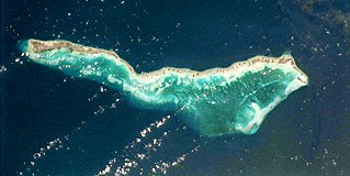
Aranuka is an atoll of Kiribati, located just north of the equator, in the Gilbert Islands. It has an area of 11.6 square kilometres and a population of 1,057 in 2010. By local tradition, Aranuka is the central island of the Gilbert group.
Aranuka Airport is an airport, located approximately one kilometre north of the centre of Buariki village on the island of Buariki, Aranuka, Kiribati.
Takaeang is the second largest island in the Aranuka atoll of Kiribati. It helps form the triangular shape of the atoll by forming the top corner of the triangle. It is connected to the larger island, Buariki, by a sandbank.

Oneeke is the smaller of the two islands which form Kuria in the North Gilbert Islands. It is separated from Buariki, the larger island, by a narrow channel. A fringing reef extends from the island.

Nonouti is an atoll and district of Kiribati. The atoll is located in the Southern Gilbert Islands, 38 km north of Tabiteuea, and 250 km south of Tarawa. The atoll is the third largest in the Gilbert Islands and is the island where the Roman Catholic religion was first established in Kiribati, in 1888.

Onotoa is an atoll of Kiribati. It is situated in the Gilbert Islands in the Pacific Ocean, 65 km (40 mi) from Tamana, the smallest island in the Gilberts. The population of Onotoa in the 2015 census was 1,393.

Sida fallax, known as yellow ilima or golden mallow, is a species of herbaceous flowering plant in the Hibiscus family, Malvaceae, indigenous to the Hawaiian Archipelago and other Pacific Islands. Plants may be erect or prostrate and are found in drier areas in sandy soils, often near the ocean. ʻIlima is the symbol of Laloimehani and is the flower for the islands of Oʻahu, Hawaiʻi, and Abemama, Kiribati.

Makin is the name of an atoll, chain of islands, located in the Pacific Ocean island nation of Kiribati. Makin is the northernmost of the Gilbert Islands, with a population of 1,990.
Buariki may refer to several places in Kiribati:

Buariki is an island in northern Tarawa Atoll in the Gilbert Islands of the Republic of Kiribati. It was the site of the Battle of Buariki in World War II.

The Coral reefs of Kiribati consists of 32 atolls and one raised coral island, Banaba, which is an isolated island between Nauru and the Gilbert Islands. The islands of Kiribati are dispersed over 3.5 million km2 (1.4 million sq mi) of the Pacific Ocean and straddle the equator and the 180th meridian, extending into the eastern and western hemispheres, as well as the northern and southern hemispheres. 21 of the 33 islands are inhabited. The groups of islands of Kiribati are:


