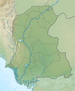
Sindh is a province of Pakistan. Located in the southeastern region of the country, Sindh is the third-largest province of Pakistan by land area and the second-largest province by population after Punjab. It is bordered by the Pakistani provinces of Balochistan to the west and north-west and Punjab to the north. It shares an International border with the Indian states of Gujarat and Rajasthan to the east; it is also bounded by the Arabian Sea to the south. Sindh's landscape consists mostly of alluvial plains flanking the Indus River, the Thar Desert of Sindh in the eastern portion of the province along the international border with India, and the Kirthar Mountains in the western portion of the province.

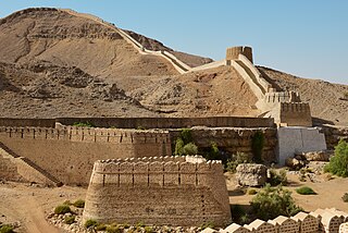
Thatta is a city in the Pakistani province of Sindh. Thatta was the medieval capital of Sindh, and served as the seat of power for three successive dynasties. Its construction was ordered by Jam Nizamuddin II in 1495. Thatta's historic significance has yielded several monuments in and around the city. Thatta's Makli Necropolis, a UNESCO World Heritage Site, is site of one of the world's largest cemeteries and has numerous monumental tombs built between the 14th and 18th centuries designed in a syncretic funerary style characteristic of lower Sindh. The city's 17th century Shah Jahan Mosque is richly embellished with decorative tiles, and is considered to have the most elaborate display of tile work in the South Asia.
The Samma dynasty was a medieval Sindhi dynasty which ruled the Sindh Sultanate from 1351 before being replaced by the Arghun dynasty in 1524.

Las Bela was a princely state in a subsidiary alliance with British India which existed until 1955. The state occupied an area of 18,254 km2 (7,048 sq mi) in the extreme southeast of the Balochistan region, with an extensive coastline on the Arabian Sea to the south. Las Bela was bordered by the princely states of Kalat and Makran to the north and west. To the east lay the province of Sind and to the southeast lay the Federal Capital Territory around the city of Karachi.
Badin is the main city and capital of Badin District in Sindh, Pakistan. It lies east of the Indus River. It is the 105th largest city in Pakistan. Badin is often called 'Sugar State' due to its production of sugar.

Thatta District is located in the southern area, locally called Laar, of the province of Sindh, Pakistan. Its capital is Thatta. It is home to a large necropolis of Makli. In 2013, several talukas were separated to form the new Sujawal District.

Sehwan is a historic city located in Jamshoro District of Sindh province in Pakistan situated on the west bank of the Indus River 80 miles (130 km) north-west of Hyderabad. The city is renowned for being the home of one of Pakistan's most important Sufi shrines, the Shrine of Lal Shahbaz Qalandar. The city also holds the status of taluka under the Jamshoro District. It was previously a part of the Dadu District; however, with the establishment of the Jamshoro District, Sehwan became linked with it.

Dadu District, is a district of Sindh Province, Pakistan. With headquarters the city of Dadu, the district was created in 1931 by merging Kotri and Mahal Kohistan tehsils from Karachi District and Mehar, Khairpur Nathan Shah, Dadu, Johi and Sehwan tehsils from Larkana District. In 2004, several talukas in the south were split off to create the new Jamshoro District. Its boundary touches with four districts of Sindh i.e. Jamshoro, Naushahro Feroze, Shaheed Benazirabad and Kamber Shahdadkot.
Jamshoro District, is a district of Sindh province, Pakistan. Jamshoro city is the capital while Kotri is the largest city of the Jamshoro District. The district borders Dadu district to the north. To the east, the Indus separates it from Shaheed Benazirabad, Matiari and Hyderabad districts. Thatta district lies to the south, and Karachi district to the south west. To the west, the Kheerthar Range separates it from the Sindh and Hub district of Baluchistan.
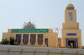
Abdullah Shah Ghazi also known as Abdullah al-Ashtar was a Muslim mystic and Sufi whose shrine is located in Clifton in Karachi, in Sindh province of Pakistan.

Sindh is a province in Pakistan.

Thana Bulla Khan or Thano Bula Khan is a town and Taluka headquarter in Jamshoro District, Sindh, Pakistan. Thana Bula Khan Taluka.
Sufism in Sindh covers the tradition of Sufism in Sindh, which is reputed to be an area of mystics. Sindh is famous for the enormous number of saints and mystics who lived there and preached peace and brotherhood. According to popular legend, 125,000 of them are buried on Makli Hill near Thatta. There is an abundance of Sufi literature produced in Sindh throughout history.
Sann is a small town and union council located in Manjhand taluka of Jamshoro District, Sindh Province, Pakistan. It lies on the western bank of the Indus river, at the mouth of an intermittent stream that brings down water from the Lakhi hills when it rains. The town is located midway between Manjhand and Amri on the main Sehwan-Kotri trunk road.
Naig Valley Sindhi is a valley and as well a hill torrent in Kirthar Mountains, Sindh, Pakistan..The name of the Naig Valley including the village denoted from a hill torrent of Nai Naig which flows throw the valley. The valley is surrounded by the Bhit and Bado mountains. Naig Valley is at a distance of 45 kilometers from Sehwan Sharif, Jamshoro District towards south west. The Date Palm, Pipal and other trees make wonderful view of the valley. The four ancient archaeological and earlier sites of Lakhshmir or Lakhmir-Ji-Mari, Buddhist's stupa, Mai Rohi and mausoleum of Pir Qamber Ali Shah can be observed at the valley.N. G. Majumdar had opined that Lakhmir-Ji-Mari is Chalcolithic site. The ancient route of Jogi's or Sufi's also leads from the valley towards Lahoot Lamakan and Hinglaj.

Sindh Tourism Development Corporation (STDC) (Sindhi: سنڌ ٽوئرزم ڊولپمينٽ ڪارپوريشن) is an organization of the Government of Sindh, Pakistan. STDC is governed by the Board of directors and provides facilities to the national and international tourists. It runs several motels and resorts across the Sindh province. STDC was incorporated on June 5, 1992.
Talti is a town and union council in Sehwan taluka of Jamshoro District, Sindh. It is located in the historical pargana of Baghban, 8 miles north of Sehwan and 2 miles off the main road from Sehwan to Larkano. It also has road connections with nearby Bhan and Bubak. There is a dhandh near Talti that is used as a source of fishery.
Unarpur is a village and deh in Manjhand taluka of Jamshoro District, Sindh. It is located close to the west bank of the Indus river, across from Matiari, on the main road from Kotri to Sehwan. As of 2017, Unarpur has a population of 4,092, in 891 households. It is the seat of a tappedar circle, which also includes the villages of Belo Unerpur, Budhapur, Nai Jetharo, and Wachero.
Shah Hasan, also spelled Shah Hassan, is a village and deh in Johi taluka of Dadu District, Sindh. It is located at the western end of Lake Manchar, about 24 miles west of Sehwan. As of 2017, Shah Hasan has a population of 2,597, in 481 households. It is the seat of a tappedar circle, which also includes the villages of Berah, Dhabhari, Dhori Kunri, Khanwah, Lohri, and Makhan Belo.
Karampur is a village and deh in Sehwan taluka of Jamshoro District, Sindh. Said to have been founded by the Talpur dynasty ruler Mir Karam Ali Talpur, it is located just north of Sehwan on the road to Larkano. The village contains the shrine of Hussain Shah, a Muslim saint who was buried here in the early 20th century.