Talti, Sindh

Last updated

Talti
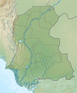
Pakistan Sindh relief map.svg
Red pog.svg
Talti
Location in Sindh
Pakistan relief location map.jpg
Red pog.svg
Talti
Talti (Pakistan)
Coordinates: 26°31′38″N67°48′42″E / 26.527191°N 67.811658°E / 26.527191; 67.811658 [1]
CountryPakistan
Region Sindh
District Jamshoro
Taluka Sehwan
Population
 (2017) [2]
  Total6,716
Time zone UTC+5 (PST)
  Summer (DST) UTC+6 (PDT)

Talti is a town and union council [3] in Sehwan taluka of Jamshoro District, Sindh. [4] [5] It is located in the historical pargana of Baghban, [6] 8 miles north of Sehwan and 2 miles off the main road from Sehwan to Larkano. [4] It also has road connections with nearby Bhan and Bubak. [4] There is a dhandh near Talti that is used as a source of fishery. [4]

As of 2017, Talti has a population of 6,716, in 1,387 households, [2] while the total population of the Talti union council is 37,694. [3] It is the seat of a tappedar circle, which also includes the villages of Bilawalpur, Duridero Jatoi, and Jatoi. [2]

The Sufi saint Makhdoom Bilawal was born here in 1451. [6] Later, around 1520, Talti was the site of the battle where the Samma dynasty was decisively defeated by Shah Beg Arghun, who as a result of the battle became the uncontested ruler of Sindh. [4] In this battle, the Sammas were joined by Sehta and Sodha tribesmen in an alliance facilitated by Makhdoom Bilawal and other local religious leaders. [7] After the battle, Shah Beg encamped at Talti for three days. [7] He had Talti and its small fort razed, its crops destroyed, and its inhabitants massacred. [7]

Around 1874, Talti was described as a small town with an estimated population of about 900: about 250 were Muslims, mostly Khaskheli, and about 650 were Hindus, mostly Lohanos. [4] It had a small police station, a government vernacular school, and a dharamsala. [4] There was no significant industry in the town at the time apart from small-scale production of cloth and rugs. [4] Local trade consisted of ghee, grain, and oil, but there was no major long-distance trade. [4]

Less than 1km east of Talti, by the road to Bubak, is the 18th-century dargah of the Muslim holy man Shahab Uddin Shah Bukhari. [8] The tomb is well-maintained by the locals and was significantly renovated in the 2000s or 10s, and new āina-kāri decoration was also added at the same time. [8]

The 1951 census recorded the village of Talti as having an estimated population of about 690, in about 350 houses. [9] It had a Sanitary Committee at that point. [9]
Related Research Articles

<span class="mw-page-title-main">Sindh</span> Province of Pakistan

Sindh is a province of Pakistan. Located in the southeastern region of the country, Sindh is the third-largest province of Pakistan by land area and the second-largest province by population after Punjab. It is bordered by the Pakistani provinces of Balochistan to the west and north-west and Punjab to the north. It shares an International border with the Indian states of Gujarat and Rajasthan to the east; it is also bounded by the Arabian Sea to the south. Sindh's landscape consists mostly of alluvial plains flanking the Indus River, the Thar Desert of Sindh in the eastern portion of the province along the international border with India, and the Kirthar Mountains in the western portion of the province.

<span class="mw-page-title-main">Dadu, Sindh</span> Pakistani city

Dadu, is a city and the capital of Dadu District located in Sindh, Pakistan. The city is located on the western bank of River Indus and is administratively subdivided into four Union councils. Dadu is famous for its tea.

The Samma dynasty was a medieval Sindhi dynasty which ruled the Sindh Sultanate from 1351 before being replaced by the Arghun dynasty in 1524.

<span class="mw-page-title-main">Sehwan</span> Place in Sindh, Pakistan

Sehwan is a historic city located in Jamshoro District of Sindh province in Pakistan situated on the west bank of the Indus River 80 miles (130 km) north-west of Hyderabad. The city is renowned for being the home of one of Pakistan's most important Sufi shrines, the Shrine of Lal Shahbaz Qalandar. The city also holds the status of taluka under the Jamshoro District. It was previously a part of the Dadu District; however, with the establishment of the Jamshoro District, Sehwan became linked with it.

Samma is a tribe that has origins in Sindh. The Samma are spread across Pakistan and North-West India. The Sandhai Muslims are Samma who converted to Islam. Offshoots of the main branch of Samma include the Jadejas and Chudasamas of India.

<span class="mw-page-title-main">Dadu District</span> District of Sindh in Pakistan

Dadu District, is a district of Sindh Province, Pakistan. With headquarters the city of Dadu, the district was created in 1931 by merging Kotri and Mahal Kohistan tehsils from Karachi District and Mehar, Khairpur Nathan Shah, Dadu, Johi and Sehwan tehsils from Larkana District. In 2004, several talukas in the south were split off to create the new Jamshoro District. Its boundary touches with four districts of Sindh i.e. Jamshoro, Naushahro Feroze, Shaheed Benazirabad and Kamber Shahdadkot.

<span class="mw-page-title-main">Jamshoro District</span> District of Sindh in Pakistan

Jamshoro District, is a district of Sindh province, Pakistan. Jamshoro city is the capital while Kotri is the largest city of the Jamshoro District. The district borders Dadu district to the north. To the east, the Indus separates it from Shaheed Benazirabad, Matiari and Hyderabad districts. Thatta district lies to the south, and Karachi district to the south west. To the west, the Kheerthar Range separates it from the Sindh and Hub district of Baluchistan.

<span class="mw-page-title-main">Matiari District</span> District of Sindh in Pakistan

Matiari District is a district in the Pakistani province of Sindh. Located on the left bank of the Indus River, Matiari became an independent district in 30 May 2004 under the military regime of Pervez Musharraf, when Hyderabad was divided into four districts — Tando Allahyar, Matiari, Tando Mohammad Khan and Hyderabad.

The Battle of Fatehpur was a key episode in the dissolution of the Samma dynasty of Sindh and its replacement by the Arghun dynasty in 1519. The conflict between the Samma dynasty of Sindh and the Arghuns lead to the Battle of Fatehpur.

Bhan Saeedabad also known as Bhan is a small town near Sehwan Sharif, Jamshoro District, Sindh, Pakistan. It has 43,108 inhabitants.

<span class="mw-page-title-main">Makhdoom Bilawal</span> 15th and 16th-century writer and Sufi saint

Makhdoom Bilawal Bin Jam Hassan Samo, was a sufi saint, philosopher and poet from Sindh, Pakistan. He is also referred as Makhdum Bilal or Bilali Makhdum. He was disple of hazrat Dost Ali Sahoni, dost Ali was direct disple of Mir Sayyid Ali Hamadani.

<span class="mw-page-title-main">Thana Bulla Khan</span>

Thana Bulla Khan or Thano Bula Khan is a town and Taluka headquarter in Jamshoro District, Sindh, Pakistan. Thana Bula Khan Taluka.

Sufism in Sindh covers the tradition of Sufism in Sindh, which is reputed to be an area of mystics. Sindh is famous for the enormous number of saints and mystics who lived there and preached peace and brotherhood. According to popular legend, 125,000 of them are buried on Makli Hill near Thatta. There is an abundance of Sufi literature produced in Sindh throughout history.

Jam Mubarak Khan Qabulio Sammo also known as Darya Khan Lashari and Darya Khan Qabulio Sammo, was a general of the Samma Dynasty of Sindh, a statesman and regent at the court of Samma ruler Jam Feroz.

Sann is a small town and union council located in Manjhand taluka of Jamshoro District, Sindh Province, Pakistan. It lies on the western bank of the Indus river, at the mouth of an intermittent stream that brings down water from the Lakhi hills when it rains. The town is located midway between Manjhand and Amri on the main Sehwan-Kotri trunk road.

Syed Bilawal Shah Noorani was a Sufi saint whose shrine is located in Balochistan, a western province of Pakistan.

Bubak is a town and union council in Sehwan taluka of Jamshoro District, Sindh. It is located on the northeastern shore of Lake Manchar, 9 miles west of Sehwan. Besides Sehwan, it is connected by road with Bhan and Talti.

Unarpur is a village and deh in Manjhand taluka of Jamshoro District, Sindh. It is located close to the west bank of the Indus river, across from Matiari, on the main road from Kotri to Sehwan. As of 2017, Unarpur has a population of 4,092, in 891 households. It is the seat of a tappedar circle, which also includes the villages of Belo Unerpur, Budhapur, Nai Jetharo, and Wachero.

Shah Hasan, also spelled Shah Hassan, is a village and deh in Johi taluka of Dadu District, Sindh. It is located at the western end of Lake Manchar, about 24 miles west of Sehwan. As of 2017, Shah Hasan has a population of 2,597, in 481 households. It is the seat of a tappedar circle, which also includes the villages of Berah, Dhabhari, Dhori Kunri, Khanwah, Lohri, and Makhan Belo.

Karampur is a village and deh in Sehwan taluka of Jamshoro District, Sindh. Said to have been founded by the Talpur dynasty ruler Mir Karam Ali Talpur, it is located just north of Sehwan on the road to Larkano. The village contains the shrine of Hussain Shah, a Muslim saint who was buried here in the early 20th century.

References

  1. "Geonames Search". Do a radial search using these coordinates here.
  2. 1 2 3 Population and household detail from block to tehsil level (Jamshoro District) (PDF). 2017. p. 18. Retrieved 25 December 2021.
  3. 1 2 "Union Council wise Thematic Analysis". Department of Health, Government of Sindh. Retrieved 25 December 2021.
  4. 1 2 3 4 5 6 7 8 9 Hughes, A.W. (1874). A Gazetteer of the Province of Sindh. London: George Bell and Sons. pp. 29, 698, 709, 726, 730, 732, 807–8. Retrieved 25 December 2021.
  5. "List of Dehs in Sindh" (PDF). Sindh Zameen. Retrieved 25 December 2021.
  6. 1 2 Kalhoro, Zulfiqar Ali (11 September 2020). "Heroic Saint of Baghban". The Friday Times. Retrieved 25 December 2021.
  7. 1 2 3 Naz, Humera (2020). "Sindh under the Mughals: Some Glimpses from Tarikh-i-Masumi and Mazhar-i-Shahjahani". Pakistan Perspectives. 24 (2): 15. SSRN   3652107 . Retrieved 27 December 2021.
  8. 1 2 Shah, Syed Shakir Ali (2016). "Archaeological Investigations in Manchar Concession Area (Area of Operation)" (PDF). Journal of Multidisciplinary Studies in Archaeology. 4: 790–1. Retrieved 27 December 2021.
  9. 1 2 Census of Pakistan, 1951: Village List (PDF). p. 19 in section "Dadu District". Retrieved 31 December 2021.