Buchberger Leite

Last updated
The Buchberger Leite Buchberger Leite, ( Geotop 272 R 003 ).jpg
The Buchberger Leite
Wilde Wolfsteiner Ohe Buchberger Leite - Wilde Wolfsteiner Ohe.jpg
Wilde Wolfsteiner Ohe
Geotope Geotop Buchberger-Leite.jpg
Geotope

The Buchberger Leite is a gorge near Hohenau in the Lower Bavarian county of Freyung-Grafenau in Bavaria.

Contents

The gorge runs between Freyung and Ringelai. [1]

As early as 1846 Bernhard Grueber and Adalbert Müller, in their book Der bayrische Wald wrote: "One shouldn't forget to visit the nearby Buchberg from Freyung, where the waters of the Ohe rush wildly through a gorge enclosed by vertical walls".

Here, after breaking through the rock formation of the Pfahl, the Wolfsteiner Ohe river carved up its way to 100 metres deep in the dark Pfahl slate rock of the Buchberger Nebenpfahl. [2] The protected area of Buchberger and Reschbachleite (officially: Schutz des Landschaftsteils Buchberger- und Reschbachleite, im Bereich der Gemeinden Freyung, Hohenau, Kumreut und Wasching, Landkreis Wolfstein) on 14 February 1961 has an area of 184 hectares. The white water gorge was designated in 2003 by the Bavarian Environment Ministry as one of the 100 mos beautiful geotopes in Bavaria. Further south its waters empty into the River Ilz.

At the westernmost of the two entrances into the gorge is the Freyung Carbide Works (Carbidwerk Freyung). In its vicinity lie the few remains of Neuenbuchberg Castle. This had been the seat of the Puchbergs since the 13th century but later went to the bishops of Passau. At the Carbide Works the trail runs through a short tunnel, cutting across a bend in the river.

Geotope

The gorge is designated by the Bavarian State Office of the Environment (LfU) as a geo-scientifically valuable geotope (geotope no.: 272R003). [3] It was assessed by the LfU with the official seal of approval to be included in the list of Bavaria’s most beautiful geotopes. [4]

Related Research Articles

<span class="mw-page-title-main">Franconia</span> Cultural region of Germany in Bavaria

Franconia is a region of Germany, characterised by its culture and Franconian dialect. While several Germanic dialects are referred to as Franconian, only the East Franconian dialects are also colloquially referred to as "Franconian", and only the East Franconian dialect area is regarded as Franconia.

Deggendorf is a Landkreis (district) in Bavaria, Germany. It is bordered by the districts of Regen, Freyung-Grafenau, Passau, Rottal-Inn, Dingolfing-Landau and Straubing-Bogen.

Freyung-Grafenau is a Landkreis (district) in Bavaria, Germany. It is bounded by the districts of Passau, Deggendorf and Regen, the Czech Republic and by Austria.

<span class="mw-page-title-main">Grafenau, Bavaria</span> Town in Bavaria, Germany

Grafenau is a town in the Freyung-Grafenau district, in Bavaria, Germany. 32 km north of Passau, the town is situated in the Bavarian Forest and is the base of the Bavarian Forest National Park Authority. Grafenau is a holiday destination with a variety of kinds of accommodation from self-catering apartments to a "holiday village".

<span class="mw-page-title-main">Ichenhausen</span> Town in Bavaria, Germany

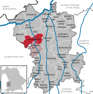
Ichenhausen is a town in the district of Günzburg, in Bavaria, Germany. It is situated on the river Günz, 9 km south of Günzburg.

<span class="mw-page-title-main">Gebsattel</span> Municipality in Bavaria, Germany

Gebsattel is a municipality in the district of Ansbach in Bavaria in Germany. It lies on the Tauber River.

<span class="mw-page-title-main">Mistelgau</span> Municipality in Bavaria, Germany

Mistelgau is a municipality in the district of Bayreuth in Bavaria in Germany. The eponymous village is the seat of both the municipality as well as the municipality association Mistelgau.

<span class="mw-page-title-main">Altenstadt, Swabia</span> Municipality in Bavaria, Germany

Altenstadt is a municipality in the district of Neu-Ulm in Bavaria in Germany.

<span class="mw-page-title-main">Eggenthal</span> Municipality in Bavaria, Germany

Eggenthal is a municipality in the district of Ostallgäu in Bavaria in Germany. It is located in the Allgäu region.

<span class="mw-page-title-main">Westendorf (Allgäu)</span> Municipality in Bavaria, Germany

Westendorf is a municipality in the district of Ostallgäu in Bavaria in Germany.

Buchberger may refer to:

<span class="mw-page-title-main">Dreisesselberg (Bavarian Forest)</span> Mountain in Germany

The Dreisesselberg is a mountain in Bavaria, Germany, in the Bavarian Forest that is 1,333 metres high.

<span class="mw-page-title-main">Ehrenbürg</span>

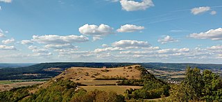
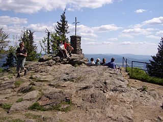
The Ehrenbürg is a double-peaked butte on the edge of the Franconian Jura in Bavaria, Germany. It is in the district of Forchheim in Upper Franconia, in the municipalities of Kirchehrenbach, Leutenbach and Wiesenthau. The north peak is the 513.9 m Walberla, the south peak the 531.7 m Rodenstein. The hill is popularly known as the Walberla.

<span class="mw-page-title-main">Großer Falkenstein</span> Mountain in Germany

The Großer Falkenstein or Great Falkenstein, is a mountain, 1,315 metres (4,314 ft) high, in the Bavarian Forest about five kilometres southeast of Bayerisch Eisenstein in the Falkenstein-Rachel region of the Bavarian Forest National Park.

<span class="mw-page-title-main">Osser</span> Mountain in Germany

The Osser is a mountain on the border between Germany and the Czech Republic, in the Bavarian Forest and Bohemian Forest and which belongs to the Kunisch Mountains.

<span class="mw-page-title-main">Lauter (Itz)</span> River of Bavaria, Germany

Lauter is a river of Bavaria, Germany. It is a right tributary of the Itz in Coburg.

<span class="mw-page-title-main">Alte Burg (Altenstein)</span>

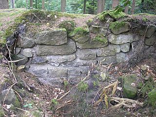
The Alte Burg is an early medieval ringwork between Altenstein and Lichtenstein in the borough of Market Maroldsweisach in the Lower Franconian county of Haßberge in the province of Lower Franconia in Bavaria, Germany.

<span class="mw-page-title-main">Veldenstein Forest</span>

The Veldenstein Forest lies in the east of the Franconian Switzerland-Veldenstein Forest Nature Park between the towns of Pegnitz and Plech.

<span class="mw-page-title-main">Pfahl (Bavarian Forest)</span>

The Pfahl is a 150-kilometre-long quartz vein that runs through the northeastern Bavarian Forest in Germany. From a geomorphological point of view, it represents a residual ridge that has been formed by weathering and erosion over millions of years.

<span class="mw-page-title-main">Danube Gorge (Weltenburg)</span>

The Danube Gorge near Weltenburg is a narrow section of the Danube Valley in the Lower Bavarian county of Kelheim, which has been recognised as a nature reserve and geotope. This section of the valley in the southern Franconian Jura is officially called the Weltenburg Narrows.

References

  1. Verlauf der Wildbachklamm „Buchberger Leite“ retrieved 16 January 2009
  2. Schautafel zur Geologie der Buchberger Leite beim Bayerischen Landesamt für Umwelt retrieved 16 January 2009
  3. Bayerisches Landesamt für Umwelt, Geotop Buchberger Leite NE von Buchberg (retrieved 1 November 2017).
  4. Bavarias schönste Geotope, Buchberger Leite am Bayerischen Pfahl (retrieved 1 November 2017)

48°49′09″N13°30′34″E / 48.819213°N 13.509557°E / 48.819213; 13.509557