Buckhorn Creek (California)

Last updated
Buckhorn Creek
Trail Crossing Buckhorn Creek.png
Thick vegetation lines the banks of Buckhorn Creek for the entirety of its course out of the Berkeley Hills (May 19th, 2022)
Location
CountryUnited States
StateCalifornia
Region Bay Area
District Contra Costa County
Physical characteristics
Mouth Upper San Leandro Reservoir
  coordinates
37°47′18″N122°05′39″W / 37.78845°N 122.09405°W / 37.78845; -122.09405
Length~2.1 miles
Basin features
Cities Moraga, California

Buckhorn Creek is a 2.1 mile long creek in Contra Costa County, California, in the San Francisco Bay Area. [1] It gets its name from the Buckhorn family who settled on the creek in the late 19th century.

Contents

Course

Buckhorn Creek begins on the western slopes of Rocky Ridge in Western Contra Costa County at an elevation of 2,020 feet above sea level. [2] It runs generally west off of Rocky Ridge before abruptly turning to the south where it runs for approximately 1.5 miles to its confluence with Kaiser Creek at the Upper San Leandro Reservoir.

History

The Buckhorn Creek watershed exists near the historical boundary between groups of the Ohlone people, who occupied much of the southern and eastern Bay Area and those of the Bay Miwok, who occupied the northern part of the East Bay and the region about Mount Diablo. For this reason it is difficult to assert that Buckhorn creek was in the "territory" of any one group. Evidence of native activity in Buckhorn Creek canyon itself is sparse, though the area as a whole is rich in archaeological material. Because of its seasonal nature, Buckhorn Creek canyon was likely occupied temporarily by groups of hunters at favorable times, rather than permanently. Local native groups often established their main villages on larger and more consistent water sources like Las Trampas Creek, Lafayette Creek and San Leandro Creek, among many others.

Geography

Looking down Buckhorn Creek Canyon from its source on Rocky Ridge. The region's steep terrain has precluded development in the catchment (July 6th, 2022) View down Buckhorn Creek.png
Looking down Buckhorn Creek Canyon from its source on Rocky Ridge. The region's steep terrain has precluded development in the catchment (July 6th, 2022)

Buckhorn Creek is a tributary to San Leandro Creek, one of the largest streams draining into the San Francisco Bay. It drains a small portion of the Berkeley Hills which are a subrange of the California Coast Ranges. The Buckhorn Creek watershed is characterized by the steep, rounded hills typical of much of the East Bay region. The climate of the area is classified as Cool-summer mediterranean, defined by wet winters and dry summers puncuated by frequent marine fogs. [3]

Though there is little development in the Buckhorn Creek watershed besides fire roads, trails and ranching hardware, nearby communities include Moraga, California and the campus of Saint Mary's College of California. Buckhorn Creek is isolated by rugged terrain and a lack of development in much of the surrounding area.

The Buckhorn Creek watershed is entirely contained within the EBMUD San Leandro watershed, a nearly 50 square mile area of protected land surrounding the Upper San Leandro Reservoir, Lake Chabot and the area west of Rocky Ridge. Access to the Buckhorn Creek watershed is restricted by a permit system. [4] Buckhorn Creek is managed to ensure clean and unpolluted inflow to the Upper San Leandro Reservoir, which is a major source of drinking water for the area's dense population. The creek can be reached via hiking trail at access points at Rancho Laguna Park and Saint Mary's College.

Ecology

A varied landscape of California mixed evergreen forest, Chaparral and grassland in Buckhorn Creek Canyon. Buckhorn Creek sits at the edge of one of the largest stretches of undeveloped land left in the Bay Area. (May 22nd, 2023) Upper Buckhorn Canyon.jpg
A varied landscape of California mixed evergreen forest, Chaparral and grassland in Buckhorn Creek Canyon. Buckhorn Creek sits at the edge of one of the largest stretches of undeveloped land left in the Bay Area. (May 22nd, 2023)

Despite originating in Contra Costa County, home to 1.61 million people, 1,626 per square mile, [5] [6] Buckhorn Creek is almost entirely undeveloped and protected from its source to its outlet. This makes it unique among the streams of the Bay Area, one of California's most densely populated regions with over 7 million people.

White Alder (Alnus rhombifolia) growing along Buckhorn Creek (July 6th, 2022) White Alder on Buckhorn Creek.jpg
White Alder (Alnus rhombifolia) growing along Buckhorn Creek (July 6th, 2022)

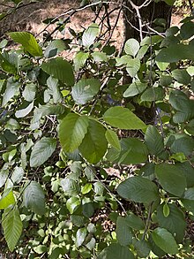
A large proportion of the streams draining into the San Francisco Estuary have undergone significant habitat degradation as a result of the intensive residential and industrial development undertaken in the region in the last century. [7] Buckhorn Creek, however, is unaffected by residential or industrial development and exhibits much more intact habitat than many other streams in the region. Mixed forests of mature Valley oak, Coast Live oak, Black oak, California buckeye and California Bay dominate much of the watershed's lower elevation areas while annual grasslands and chaparral cover the rugged hilltops and exposed slopes.

Wildflowers blooming on the hills above Buckhorn Creek with Rocky Ridge rising in the background (April 6th, 2021) Wildflowers above Buckhorn Creek.png
Wildflowers blooming on the hills above Buckhorn Creek with Rocky Ridge rising in the background (April 6th, 2021)

Buckhorn Creek's flow is heavily dependant on rainfall and can become greatly diminished during the dry period from June to November. During droughts there may only be water in pools in some sections of the stream.

Riparian vegetation along the creek includes arroyo willow, white alder and Fremont cottonwood.

Buckhorn Creek is a crucial source of water for the vibrant wildlife communities inhabiting the area. The creek supports numerous species of birds, both migratory and resident. Great horned owl and Screech owl are commonly seen in the evenings near the creek. Black-tailed deer, coyotes, bobcats, gray foxes and cottontail rabbit among many other species live in the Buckhorn Creek watershed.

In the 1980s and again in the 2000s, in response to persistent drought conditions, proposals were submitted to expand the East Bay's water storage capacity by inundating Buckhorn Creek and Kaiser Creek in what was the be called the "Buckhorn Reservoir". The reservoir would have had a capacity of 143,000 acre-feet and would have inundated the majority of both valleys and all of the habitat contained therein. Fierce opposition from both environmentalist groups and members of the local community caused EBMUD to shelve the project.

Rainbow trout population

Buckhorn Creek supports a population of native Coastal rainbow trout in years where there is enough flow to support the fish over the dry summer season. [7] The Central California Coast Steelhead DPS is federally listed as threatened as a result of habitat loss and degradation, as well as the widespread installation of migration barriers. [8] Rainbow trout migrate from Upper San Leandro Reservoir to Buckhorn Creek to spawn during periods of high water. They have been observed in the lower and upper reaches of the creek on multiple occasions between the 1970s and early 2000s. However, due to its relative low flow and poor instream substrate for spawning, Buckhorn Creek has limited value to trout restoration. [1] [7]

See also

Related Research Articles

<span class="mw-page-title-main">Stevens Creek (California)</span> Creek in Santa Clara County, California

Stevens Creek is a 20.9-mile-long (33.6 km) stream in Santa Clara County, California. The creek originates in the Santa Cruz Mountains on the western flank of Black Mountain in the Monte Bello Open Space Preserve near the terminus of Page Mill Road at Skyline Boulevard. It flows southeasterly through the Stevens Creek County Park before turning northeast into Stevens Creek Reservoir. It then continues north for 12.5 miles (20.1 km) through Cupertino, Los Altos, Sunnyvale and Mountain View before emptying into the San Francisco Bay at the Whisman Slough, near Google's main campus.

<span class="mw-page-title-main">Alameda Creek</span> River in California, United States

Alameda Creek is a large perennial stream in the San Francisco Bay Area. The creek runs for 45 miles (72 km) from a lake northeast of Packard Ridge to the eastern shore of San Francisco Bay by way of Niles Canyon and a flood control channel. Along its course, Alameda Creek provides wildlife habitat, water supply, a conduit for flood waters, opportunities for recreation, and a host of aesthetic and environmental values. The creek and three major reservoirs in the watershed are used as water supply by the San Francisco Public Utilities Commission, Alameda County Water District and Zone 7 Water Agency. Within the watershed can be found some of the highest peaks and tallest waterfall in the East Bay, over a dozen regional parks, and notable natural landmarks such as the cascades at Little Yosemite and the wildflower-strewn grasslands and oak savannahs of the Sunol Regional Wilderness. After an absence of half a century, ocean-run steelhead trout are able to return to Alameda Creek to mingle with remnant rainbow trout populations. Completion of a series of dam removal and fish passage projects, along with improved stream flows for cold-water fish and planned habitat restoration, enable steelhead trout and Chinook salmon to access up to 20 miles (32 km) of spawning and rearing habitat in Alameda Creek and its tributaries. The first juvenile trout migrating downstream from the upper watershed through lower Alameda Creek toward San Francisco Bay was detected and documented in April 2023.

<span class="mw-page-title-main">Los Gatos Creek (Santa Clara County)</span> River in California, United States

The Los Gatos Creek runs 24 miles (39 km) in California through Santa Clara Valley Water District's Guadalupe Watershed from the Santa Cruz Mountains northward through the Santa Clara Valley until its confluence with the Guadalupe River in downtown San Jose. The Guadalupe River then continues onward into San Francisco Bay.

<span class="mw-page-title-main">San Francisquito Creek</span> River in California, United States

San Francisquito Creek is a creek that flows into southwest San Francisco Bay in California, United States. Historically it was called the Arroyo de San Francisco by Juan Bautista de Anza in 1776. San Francisquito Creek courses through the towns of Portola Valley and Woodside, as well as the cities of Menlo Park, Palo Alto, and East Palo Alto. The creek and its Los Trancos Creek tributary define the boundary between San Mateo and Santa Clara counties.

<span class="mw-page-title-main">San Leandro Creek</span> River in California, United States

San Leandro Creek is a 21.7-mile-long (34.9 km) year-round natural stream in the hills above Oakland in Alameda County and Contra Costa County of the East Bay in northern California.

<span class="mw-page-title-main">Wildcat Creek (California)</span> River in California, United States

Wildcat Creek is a 13.4-mile-long (21.6 km) creek which flows through Wildcat Canyon situated between the Berkeley Hills and the San Pablo Ridge, emptying into San Pablo Bay in Contra Costa County, northern California.

<span class="mw-page-title-main">San Pablo Creek</span> River in California, United States

San Pablo Creek is an 18.7-mile-long (30.1 km) creek in Contra Costa County, California, United States, which drains the canyon or valley between the San Pablo Ridge and the Sobrante Ridge, parts of the Pacific Coast Ranges east of San Francisco Bay.

Rodeo Creek is an 8.3-mile-long (13.4 km) intermittent stream in western Contra Costa County, California running through the town of Rodeo to San Pablo Bay.

<span class="mw-page-title-main">Pinole Creek</span> River in California, United States

Pinole Creek is a stream in western Contra Costa County, in the East Bay region of the San Francisco Bay Area, California.

<span class="mw-page-title-main">Marsh Creek (California)</span> River in California, United States

Marsh Creek is a stream in east Contra Costa County, California in Northern California which rises on the eastern side of Mount Diablo and flows 30 miles (48 km) to the Sacramento–San Joaquin River Delta at Oakley, California, near Big Break Regional Shoreline. The creek flows through Marsh Creek State Park (California), where water is impounded to form Marsh Creek Reservoir, then through the city of Brentwood, California.

<span class="mw-page-title-main">Searsville Dam</span> Dam in California, USA

Searsville Dam is a masonry dam in San Mateo County, California that was completed in 1892, one year after the founding of Stanford University, and impounds Corte Madera Creek to form a reservoir known as Searsville Reservoir or Searsville Lake. Searsville Dam is located in the Jasper Ridge Biological Preserve and is owned and operated by Stanford University. Neighboring cities include Woodside and Portola Valley, California.

<span class="mw-page-title-main">Corte Madera Creek (San Mateo County)</span> River in California, United States

Corte Madera Creek is a 7.3-mile-long (11.7 km) creek that flows north-northwest to Searsville Dam and then joins with Bear Creek to form San Francisquito Creek in California.

Cordilleras Creek is a 3.8-mile-long (6.1 km) northward-flowing stream originating in the Pulgas Ridge Open Space Preserve in the foothills of the Santa Cruz Mountains. It forms the border between San Carlos and Redwood City in San Mateo County, California, United States before entering Smith Slough where its waters course to Steinberger Slough and thence to San Francisco Bay.

<span class="mw-page-title-main">Upper San Leandro Reservoir</span>

Upper San Leandro Reservoir is an artificial lake in Alameda County and Contra Costa County, California which provides water for the East Bay Municipal Utility District (EBMUD). It is impounded by the earth-filled San Leandro Dam on San Leandro Creek, located at the southeast end of the lake.

<span class="mw-page-title-main">Las Trampas Creek</span> River in California, United States

Las Trampas Creek is a 12.37 mile long north-east flowing stream in Contra Costa County, California. Its watershed comprises an area of 17,238 acres. It's mean daily flow is approximately 15.4 cfs.

<span class="mw-page-title-main">East Bay Redwoods</span> Isolated population of coast redwoods

The East Bay Redwoods are an isolated population of coast redwoods that exist a considerable distance inland from the coast in the Berkeley Hills in western Contra Costa County, California. Stands of Sequoia sempervirens, the Coast Redwood, occur on the west coast from Big Sur to extreme southwestern Oregon. Their preferred habitat is the temperate and perennially foggy western slopes of the California Coast Ranges; a reliance on marine climates generally restricts their range to a narrow band along the central and northern coasts of California.

<span class="mw-page-title-main">Rocky Ridge (California)</span> Mountain in SF Bay Area

Rocky Ridge is a 2,020 ft (620 m) ridge in the Inner Coast Ranges in western Contra Costa County, California, in the San Francisco Bay Area. Being the second-highest mountain in the county, it is visible from much of the surrounding area. The ridge is a very prominent feature in the geography of the towns of Lafayette, Moraga and Orinda, California.

<span class="mw-page-title-main">Lafayette Creek (California)</span> Stream in Contra Costa County

Lafayette Creek is a 3.78 mi (6.08 km) long creek in Contra Costa County, California in the San Francisco Bay Area. It is a tributary of Las Trampas Creek.

<span class="mw-page-title-main">Tice Creek</span> River

Tice Creek is a minor creek in Contra Costa County, California in the San Francisco Bay Area. It is approximately 4.1 miles (6.6 km) long. It is a tributary of Las Trampas Creek, which itself is a major tributary to Walnut Creek which in turn drains into Suisun Bay. The name comes from the surname of a settler family who settled in the Tice valley.

<span class="mw-page-title-main">Bollinger Canyon Creek</span> Creek in Central California

Bollinger Canyon Creek is an approximately 6.72-mile-long stream in Contra Costa County, California in the San Francisco Bay Area. It is a tributary of San Ramon Creek which is part of the Walnut Creek watershed. The creek derives its name from the surname of a family who settled in the area in the 19th century.

References

  1. 1 2 "Contra Costa County Creeks Inventory" (PDF). www.cccleanwater.org. p. 62.
  2. "Contra Costa County Watershed Atlas" (PDF). www.cccleanwater.org.
  3. "Atlas of the Biodiversity of California". wildlife.ca.gov. Retrieved 2023-12-06.
  4. "San Leandro Creek Watershed | Alameda County Flood Control District" . Retrieved 2023-12-05.
  5. "U.S. Census Bureau QuickFacts: Contra Costa County, California". www.census.gov. Retrieved 2023-12-06.
  6. "Demographics | Contra Costa County, CA Official Website". www.contracosta.ca.gov. Retrieved 2023-12-05.
  7. 1 2 3 Leidy, Robert. "Historical Distribution and Current Status of Steelhead/Rainbow Trout (Oncorhynchus mykiss) in Streams of the San Francisco Estuary, California" (PDF). www.cemar.org.
  8. Fisheries, NOAA (2021-12-06). "Central California Coast Steelhead | NOAA Fisheries". NOAA. Retrieved 2023-12-06.