
East Bay Municipal Utility District (EBMUD), colloquially referred to as "East Bay Mud", is a public utility district which provides water and sewage treatment services for an area of approximately 331 square miles (860 km2) in the eastern side of the San Francisco Bay. As of 2018, EBMUD provides drinking water for approximately 1.4 million people in portions of Alameda County and Contra Costa County in California, including the cities of Richmond, El Cerrito, Hercules, San Pablo, Pinole, Lafayette, Moraga, Orinda, Danville, Oakland, Piedmont, Emeryville, Berkeley, Albany, Alameda, San Leandro, neighboring unincorporated regions, and portions of cities such as Hayward and San Ramon. Sewage treatment services are provided for 685,000 people in an 88-square-mile area (as of 2018). EBMUD currently has an average annual growth rate of 0.8% and is projected to serve 1.6 million people by 2030. Headquartered in Oakland, EBMUD owns and maintains 2 water storage reservoirs on the Mokelumne River, 5 terminal reservoirs, 91 miles (146 km) of water transmission aqueducts, 4,100 miles (6,600 km) of water mains, 6 water treatment plants (WTPs), 29 miles (47 km) of wastewater interceptor sewer lines and a regional wastewater treatment facility (WWTF) rated at a maximum treatment capacity of 320 MGD.
Calaveras Reservoir is located primarily in Santa Clara County, California, with a small portion and its dam in Alameda County, California. In Spanish, Calaveras means "skulls".

The Mokelumne River is a 95-mile (153 km)-long river in northern California in the United States. The river flows west from a rugged portion of the central Sierra Nevada into the Central Valley and ultimately the Sacramento–San Joaquin River Delta, where it empties into the San Joaquin River-Stockton Deepwater Shipping Channel. Together with its main tributary, the Cosumnes River, the Mokelumne drains 2,143 square miles (5,550 km2) in parts of five California counties. Measured to its farthest source at the head of the North Fork, the river stretches for 157 miles (253 km).

Anthony Chabot Regional Park is a regional park in Oakland, Alameda County, California in the United States. It is part of the East Bay Regional Park District system, and covers 5,067 acres (2,051 ha) in the San Leandro Hills adjacent to Oakland, San Leandro and Castro Valley. Popular activities include hiking, cycling and horseback riding. A gun range operated by the Chabot Gun Club was shut down in 2016, following complaints about pollution.

Alameda Creek is a large perennial stream in the San Francisco Bay Area. The creek runs for 45 miles (72 km) from a lake northeast of Packard Ridge to the eastern shore of San Francisco Bay by way of Niles Canyon and a flood control channel. Along its course, Alameda Creek provides wildlife habitat, water supply, a conduit for flood waters, opportunities for recreation, and a host of aesthetic and environmental values. The creek and three major reservoirs in the watershed are used as water supply by the San Francisco Public Utilities Commission, Alameda County Water District and Zone 7 Water Agency. Within the watershed can be found some of the highest peaks and tallest waterfall in the East Bay, over a dozen regional parks, and notable natural landmarks such as the cascades at Little Yosemite and the wildflower-strewn grasslands and oak savannahs of the Sunol Regional Wilderness. After an absence of half a century, ocean-run steelhead trout are able to return to Alameda Creek to mingle with remnant rainbow trout populations. Completion of a series of dam removal and fish passage projects, along with improved stream flows for cold-water fish and planned habitat restoration, enable steelhead trout and Chinook salmon to access up to 20 miles (32 km) of spawning and rearing habitat in Alameda Creek and its tributaries. The first juvenile trout migrating downstream from the upper watershed through lower Alameda Creek toward San Francisco Bay was detected and documented in April 2023.
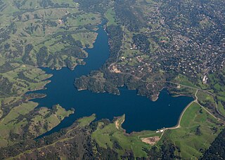
Lake Chabot is a man-made lake covering 317 acres (1.3 km2) in Alameda County, California, United States. Part of the lake lies within Oakland city limits, but most of it lies in unincorporated Castro Valley, just east of San Leandro. It was formed by the damming of San Leandro Creek. The lake was completed in 1875 to serve as a primary source of water for the East Bay.
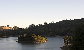
Lake Del Valle is a storage reservoir located 10 miles (16 km) southeast of Livermore, in Alameda County, California. It is within Del Valle Regional Park.

San Antonio Reservoir is located in Alameda County, California, about three miles east-southeast of Sunol. It was built in 1964 by the City and County of San Francisco. Formed by the James H. Turner Dam across San Antonio Creek not far above where it flows into Alameda Creek, its purpose is to store water from the Hetch Hetchy Aqueduct and local wells and watersheds. It has a capacity of 50,500 acre-feet (62,300,000 m3).

San Leandro Creek is a 21.7-mile-long (34.9 km) year-round natural stream in the hills above Oakland in Alameda County and Contra Costa County of the East Bay in northern California.

The San Pablo Reservoir is an open cut terminal water storage reservoir owned and operated by the East Bay Municipal Utility District (EBMUD). It is located in the valley of San Pablo Creek, north of Orinda, California, United States, and south of El Sobrante and Richmond, east of the Berkeley Hills between San Pablo Ridge and Sobrante Ridge.
Briones Reservoir is an open cut terminal water storage reservoir located in western Contra Costa County, in the East Bay region of the San Francisco Bay Area, California.

Cull Canyon Regional Recreation Area (CCRRA) is a regional park located in Castro Valley, Alameda County, California. It is part of the East Bay Regional Park District (EBRPD) system.

Lake Chabot Regional Park is a regional park located in the southern Berkeley Hills in Alameda County, California. It is part of the East Bay Regional Parks system.

The Los Vaqueros Reservoir and watershed is located in the northern Diablo Range, within northeastern Contra Costa County, northern California. It was completed by the Contra Costa Water District (CCWD) in 1998 to improve the quality of drinking water for its 550,000 customers in Central and Eastern Contra Costa County. The reservoir is accessible via Vasco Road, a road which connects Brentwood and Livermore.

Pardee Dam is a 345-foot (105 m)-high structure across the Mokelumne River which marks the boundary between Amador and Calaveras Counties, located in the foothills of the Sierra Nevada approximately 30 miles (48 km) northeast of Stockton.

The Mokelumne Aqueduct is a 95-mile (153 km) water conveyance system in central California, United States. The aqueduct is supplied by the Mokelumne River and provides water to 35 municipalities in the East Bay in the San Francisco Bay Area. The aqueduct and the associated dams, pipelines, treatment plants and hydroelectric system are owned and operated by the East Bay Municipal Utility District (EBMUD) and provide over 90 percent of the water used by the agency.

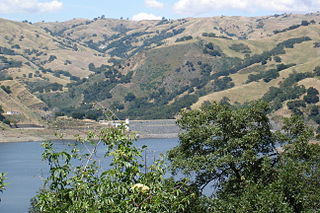
Camanche Dam is an earthfill Dam on the Mokelumne River in the central California, about 20 mi (32 km) from East Lodi. The dam and reservoir lie in the Sierra Nevada foothills in San Joaquin County. Construction of Camanche Dam was started in 1963 and completed in 1964. East Bay Municipal Utilities District (EBMUD) owns and operates it. The purpose of Camanche Dam and reservoir is to provide flood control, water flows for agriculture, habitat for fisheries and recreation for community.

O'Shaughnessy Dam is a 430-foot (131 m) high concrete arch-gravity dam in Tuolumne County, California, United States. It impounds the Tuolumne River, forming the Hetch Hetchy Reservoir at the lower end of Hetch Hetchy Valley in Yosemite National Park, about 160 miles (260 km) east of San Francisco. The dam and reservoir are the source for the Hetch Hetchy Aqueduct, which provides water for over two million people in San Francisco and other municipalities of the west Bay Area. The dam is named for engineer Michael O'Shaughnessy, who oversaw its construction.
Moccasin Dam is a small dam on Moccasin Creek in Tuolumne County, California, in the town of Moccasin, west of Yosemite. It holds the Moccasin Reservoir. The dam, reservoir and associated hydroelectric power plant are part of the Hetch Hetchy Project, which provide water and power to the city of San Francisco. The dam is located near the junction of Highway 120 and Highway 49.

The East Bay Redwoods are an isolated population of coast redwoods that exist a considerable distance inland from the coast in the Berkeley Hills in western Contra Costa County, California. Stands of Sequoia sempervirens, the Coast Redwood, occur on the west coast from Big Sur to extreme southwestern Oregon. Their preferred habitat is the temperate and perennially foggy western slopes of the California Coast Ranges; a reliance on marine climates generally restricts their range to a narrow band along the central and northern coasts of California.


