Related Research Articles

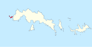
The Larsen Islands are a small group of islands north-west of Moreton Point, the western extremity of Coronation Island, in the South Orkney Islands of Antarctica. They were discovered by Captains George Powell and Nathaniel Palmer on the occasion of their joint cruise in December 1821. The islands were named on Petter Sørlle's chart, based upon his survey of the South Orkney Islands in 1912–1913, in honour of Carl Anton Larsen.

Church Bay is a bay 4.5 nautical miles (8 km) wide, indenting the north coast of South Georgia between Low Rock Point and Cape North. It is separated from Schlieper Bay by the Scree Gap.
Boot Rock is a rock, 30 metres (100 ft) high, which lies 0.1 nautical miles (0.2 km) off the southeast side of Candlemas Island in the South Sandwich Islands. It was charted and named by Discovery Investigations personnel on the Discovery II in 1930.
Castor Rock is the northern of a pair of large off-lying rocks south of Vindication Island, South Sandwich Islands. This rock, with its neighbor Pollux Rock, was named "Castor and Pollux", after the Dioscuri of Greek mythology, during the survey of these islands from RRS Discovery II in 1930. In 1971 the UK Antarctic Place-Names Committee recommended that they be assigned unambiguous names making each individually identifiable, and this has been done by naming the northern one Castor Rock and the southern one Pollux Rock.
Cook Rock is an arched rock, 45 metres (150 ft) high, lying close east of Trousers Rock and 0.3 nautical miles (0.6 km) northeast of Vindication Island in the South Sandwich Islands. It was charted in 1930 by Discovery Investigations personnel on the Discovery II and named for Captain James Cook.
Crosscut Point is a series of jagged rocks forming the north end of Vindication Island in the South Sandwich Islands. It was charted in 1930 by Discovery Investigations personnel on the Discovery II, and so named because numerous crosscutting dikes have withstood weathering and produced this irregular formation.
Trousers Rock is a rock with a prominent wave-cut arch, lying immediately west of Cook Rock and 0.3 nautical miles (0.6 km) northeast of Vindication Island in the South Sandwich Islands. Charted in 1930 and given this descriptive name by DI personnel on the Discovery II.
Pollux Rock is the southern of a pair of large off-lying rocks south of Vindication Island, South Sandwich Islands. This rock, with its neighbour Castor Rock, was named "Castor and Pollux" during the survey of these islands from RRS Discovery II in 1930. In 1971 United Kingdom Antarctic Place-Names Committee (UK-APC) recommended that they be assigned unambiguous names making each individually identifiable, and this has been done by naming the southern one Pollux Rock and the northern one Castor Rock.
Mohaupt Point is the eastern point of Currituck Island, in the Highjump Archipelago, Antarctica. The name "Mohaupt Island" was given by Advisory Committee on Antarctic Names (US-ACAN) in 1956 to the northern portion of Currituck Island, then thought to be a separate feature. Subsequent Soviet expeditions in 1956–57 found that feature to be part of Currituck Island and US-ACAN has reapplied the name to the point described. It is named for H.E. Mohaupt, an air crewman on U.S. Navy Operation Highjump photographic flights in this area in 1946–47.
Gorgon Pool is a lake, or perhaps lagoon, between the Chimaera Flats and Kraken Cove in Candlemas Island, South Sandwich Islands. It was named by the UK Antarctic Place-Names Committee in association with nearby Medusa Pool. The Gorgon is a mythical creature of Homer's Iliad, linked in other mythology with Medusa.
Lucifer Hill is a reddish, cindery, sulphur-streaked hill forming the summit of the northern section of Candlemas Island in the South Sandwich Islands. It was one of the most active volcanic vents in this island chain at the time of HMS Protector's survey in 1964. The name applied by the UK Antarctic Place-Names Committee after Lucifer refers to the diabolical and infernal mythical association of active volcanoes. Clinker Gulch extends from Lucifer Hill to the northern shore of Candlemas.
Medusa Pool is a tidal lagoon that occupies the west side of the central lowlands of Candlemas Island in the South Sandwich Islands. The name, given by the UK Antarctic Place-Names Committee in 1971, is associated in classical mythology with the geomorphologically similar Gorgon Pool nearby, Medusa being one of the gorgons.
Heed Rock is a very small rock, awash at high water and virtually hidden from sight, lying 1 nautical mile (2 km) south of Brown Island in the Wauwermans Islands in the Wilhelm Archipelago, Antarctica. It was shown on an Argentine government chart of 1950, but not named. It was surveyed by the British Naval Hydrographic Survey Unit in 1956–57, and so named by the UK Antarctic Place-Names Committee as a caution to mariners.
Mount Machatschek is a prominent, mainly snow-covered mountain in northern Adelaide Island, Antarctica, about 14 nautical miles (26 km) southwest of Mount Velain. It was mapped from air photos taken by the Ronne Antarctic Research Expedition (1947–48) and the Falkland Islands and Dependencies Aerial Survey Expedition (1956–57), and was named by the UK Antarctic Place-Names Committee after Austrian geomorphologist Fritz Machatschek (1876–1957), who was the joint author with Erich von Drygalski of Gletscherkunde, 1942.
Saw Rock is a rock, 25 m high, lying 0.4 nautical miles (0.7 km) north of Crosscut Point, the north extremity of Vindication Island, in the South Sandwich Islands. Charted in 1930 by DI personnel on the Discovery II and named by them, probably for association with Crosscut Point.
Sarcophagus Point is a point at the southeast side of Sea Serpent Cove on the west coast of Candlemas Island, South Sandwich Islands. The point, with a spine of lava cliffs, almost cuts off Medusa Pool from the sea. It was referred to as "The Sarcophagus" on a sketch-survey of Sea Serpent Cove made by a boat party from RRS Discovery II in 1930.

Sölch Glacier is a glacier on the Pernik Peninsula of the Loubet Coast in Graham Land, flowing west to Salmon Cove just north of Kanchov Peak on the east side of Lallemand Fjord. It was mapped from air photos taken by the Falkland Islands and Dependencies Aerial Survey Expedition, 1956–57, and named by United Kingdom Antarctic Place-Names Committee for Johann Sölch (1883–1951), an Austrian glacial geologist and glaciologist.

Hole Rock is the largest of several rocks lying close north of North Foreland, the northeast cape of King George Island, in the South Shetland Islands. It was charted in 1937 by Discovery Investigations personnel on the Discovery II and so named because a conspicuous hole extends through it.
League Rock is a distinctive rounded rock lying southwest of Box Reef, off the south end of Adelaide Island, Antarctica. It was surveyed by the Royal Navy Hydrographic Survey Unit, 1962–63, and was so named by the UK Antarctic Place-Names Committee because the rock lies one league distant from what was then Adelaide Station.

Limit Rock is a rock awash, lying 2 nautical miles (4 km) east of North Foreland, the northeast cape of King George Island, in the South Shetland Islands on the Southern Ocean. It was charted in 1937 by Discovery Investigations personnel on the Discovery II, and so named because it marks the eastern limit of foul ground surrounding North Foreland.
References
- ↑ "Buddha Rock". Geographic Names Information System . United States Geological Survey, United States Department of the Interior . Retrieved 27 September 2011.
![]() This article incorporates public domain material from "Buddha Rock". Geographic Names Information System . United States Geological Survey.
This article incorporates public domain material from "Buddha Rock". Geographic Names Information System . United States Geological Survey.