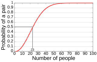
In probability theory, the birthday problem or birthday paradox concerns the probability that, in a set of n randomly chosen people, some pair of them will have the same birthday. By the pigeonhole principle, the probability reaches 100% when the number of people reaches 367. However, 99.9% probability is reached with just 70 people, and 50% probability with 23 people. These conclusions are based on the assumption that each day of the year is equally probable for a birthday.
Hikawa was a district located in Shimane Prefecture, Japan.

Soyuz TM-23 was the 25th manned spacecraft to visit the Soviet Space Station Mir

The location of the geographical centre of Europe depends on the definition of the borders of Europe, mainly whether remote islands are included to define the extreme points of Europe, and on the method of calculating the final result. Thus, several places claim to host this hypothetical centre.

The goodness of fit of a statistical model describes how well it fits a set of observations. Measures of goodness of fit typically summarize the discrepancy between observed values and the values expected under the model in question. Such measures can be used in statistical hypothesis testing, e.g. to test for normality of residuals, to test whether two samples are drawn from identical distributions, or whether outcome frequencies follow a specified distribution. In the analysis of variance, one of the components into which the variance is partitioned may be a lack-of-fit sum of squares.

The European route E 22 is one of the longest European routes. It has a length of about 5,320 km (3,310 mi). Many of the E-roads have been extended into Asia since the year 2000; the E 22 was extended on 24 June 2002.

Kazlų Rūda Municipality is one of 60 municipalities in Lithuania.
Goldpan Provincial Park is a provincial park in British Columbia, Canada, located on the Trans-Canada Highway between Lytton (W) and Spences Bridge (E), on the Thompson River. The park has camping above the highway and a picnic area and riverfront below.
Mehana is a town and commune in Niger.

Pozières is a commune in the Somme department in Hauts-de-France in northern France.

Advanced Landing Grounds (ALGs) were temporary advance airfields constructed by the Allies during World War II during the liberation of Europe. They were built in the UK prior to the invasion and thereafter in northwest Europe from 6 June 1944 to V-E Day, 7 May 1945.

Putkaste is a village in Lääne-Nigula Parish, Lääne County, in western Estonia.
Mustla is a village in Saaremaa Parish, Saare County in western Estonia.
Ridala is a village in Saaremaa Parish, Saare County in western Estonia.
Jihanah District is a district of the Sana'a Governorate, Yemen. As of 2003, the district had a population of 50,747 inhabitants.
Eerikulaid is an island belonging to the country of Estonia.
Härjamaa is an island belonging to the country of Estonia.
Liia is an island belonging to the country of Estonia.
Rohurahu is an island belonging to the country of Estonia.
Kelachay District is a district (bakhsh) in Rudsar County, Gilan Province, Iran. At the 2006 census, its population was 34,268, in 9,878 families. The District has two cities: Kelachay and Vajargah. The District has two rural districts (dehestan): Bibalan Rural District and Machian Rural District.


