
The École Camondo is a five-year private school of product design and interior architecture located in Paris, France, which was created in 1944 and was recognized by the French Ministry of Education in 1989. It is named after the Camondo family, a European family of Jewish financiers and philanthropists.
The City of Adam is a place which appears in the Bible in the Book of Joshua 3:16, where it is described as standing "beside Zarethan" on the east bank of the Jordan. It is called also Damia. According to the Book of Joshua, the flow of the water was arrested, and rose up "upon an heap" at the time of the Israelites' passing over.

Nalpur is a census town in Sankrail CD Block of Howrah Sadar subdivision in Howrah district in the Indian state of West Bengal. It is a part of Kolkata Urban Agglomeration.

South Elgin High School (SEHS), opened August 24, 2005, is a four-year high school located in South Elgin, Illinois, a northwest suburb of Chicago, Illinois, in the United States. It is part of Elgin Area School District U46. The school is located on property formerly owned by the Kenyon Brothers Dairy Farms.
Ramganga is a tributary of the river Ganga, originating in Uttarakhand state, India.
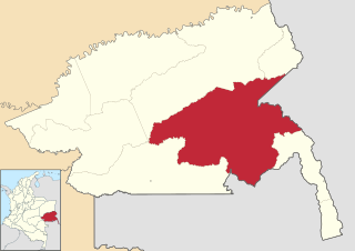
Puerto Colombia is a town and municipality located in the Guainía Department, Republic of Colombia.
The 1941 Eccles rail crash occurred on 30 December 1941 at the east end of Eccles railway station in Lancashire, England.
Huando District is one of nineteen districts of the province Huancavelica in Peru.
Wickenby railway station was a station in Wickenby, Lincolnshire on the line between Lincoln and Grimsby, opened in 1848 and closed in 1965.
Zambrzyce-Plewki is a village in the administrative district of Gmina Rutki, within Zambrów County, Podlaskie Voivodeship, in north-eastern Poland.

Hineno Station is a railway station in Izumisano, Osaka Prefecture, Japan.
Starostwo is a settlement in the administrative district of Gmina Skulsk, within Konin County, Greater Poland Voivodeship, in west-central Poland.

Suchodaniec is a village in the administrative district of Gmina Izbicko, within Strzelce County, Opole Voivodeship, in south-western Poland.
Zorģi is a village in Iecava Municipality in the historical region of Zemgale, and the Zemgale Planning Region in Latvia.
The Conestoga Trail System is an orange-blazed hiking trail that stretches 63 miles (101 km) through Lancaster County, Pennsylvania. The trail begins in the Furnace Hills about 16 miles (26 km) north of the city of Lancaster, where it intersects the Horse-Shoe Trail. It then winds its way south along various creeks through central Lancaster and County Central Park. From there it turns southwest to pass through the scenic and rather challenging river hills before crossing the Susquehanna River to reach the Mason-Dixon Trail in York County.
Karakaya, Söke is a village in the District of Söke, Aydın Province, Turkey. As of 2010 it had a population of 318 people.
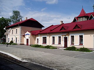
Vorokhta is a railway station that is located in town of Vorokhta, Ivano-Frankivsk Oblast in Ukraine. It is part of the Ivano-Frankivsk administration. The station is located next to the town's center and situated on a segment between Deliatyn and Dilove which is next to the border with Romania.

Axelborg is a building on Vesterbrogade in Copenhagen, Denmark, home to the Danish Agriculture and Food Council. DLG Group is also headquartered in the building. The building was built in 1920 and was originally constructed for a bank. An Irma flagship store opened on the ground floor in 2015.

Tzu Chi University of Science and Technology is a private university in Hualien City, Hualien County, Taiwan.
Saupsdorf is a village in Saxony, Germany, situated in the district of Sächsische Schweiz-Osterzgebirge. It was one of the villages that composed the municipality of Kirnitzschtal. Since 1 October 2012, it has been part of the municipality of Sebnitz.


