Hett is a large hamlet in County Durham, England. It is situated a few miles south of Durham. Hett is largely surrounded by farmland. To the south, rape fields are predominant while at the northern end, cattle are grazed year round. To the north-west of Hett lies Sunderland Bridge, a small hamlet with a population of under 50 people (2004). Hett contains a small pond and a football pitch. It is believed to derive its name from its topography - the village sits on a low rounded hill shaped like a hat.
Aroer is a biblical town on the north bank of the River Arnon to the east of the Dead Sea, in present-day Jordan. The town was an ancient Moabite settlement, and is mentioned in the Bible.

The Harenna shrew is a white-toothed shrew found only in one location in the Bale Mountains in southern Ethiopia. It occurs within an area of less than ten square kilometres, and is listed as a critically endangered species, due to habitat loss and a restricted range.
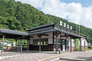
Yachiho Station is a railway station on the Koumi Line in the town of Koumi, Minamisaku District, Nagano Prefecture, Japan, operated by East Japan Railway Company.
Llipata District is one of five districts of the province Palpa in Peru.
Vilca District is one of nineteen districts of the Huancavelica Province in Peru.
Dobra Wola is a village in the administrative district of Gmina Włocławek, within Włocławek County, Kuyavian-Pomeranian Voivodeship, in north-central Poland.

The Roman Catholic Archdiocese of Hyderabad is an archdiocese located in the city of Hyderabad in India.
KIta-Hiroshima Station is a railway station on the Chitose Line located in Kitahiroshima, Hokkaidō, Japan.
Berqayel or Berkayel (برقايل) is one of the largest and the most historical towns in Akkar Governorate in northern Lebanon. Berkail is about 25 km north Tripoli. Berkail is well known by its olive production and green fields. It is a Sunni Muslim community.

Minami-Sakaide Station is a railway station on the Suigun Line in Naka, Ibaraki Prefecture, operated by East Japan Railway Company.

Sørkapp is the southernmost point on Sørkappøya, 8 kilometres (5.0 mi) south of Spitsbergen, the largest island in the Svalbard archipelago, Arctic Norway. It was originally named Point Lookout (1612). The cape itself is 1 kilometre (0.62 mi) long. The point is bordered by the Greenland Sea to the west, the Norwegian Sea to the south and the Barents Sea to the east. The point is within the Sørkapp Bird Sanctuary.
Ataq District is a district of the Shabwah Governorate in Yemen. As of 2003, the district had a population of 37,315 inhabitants.
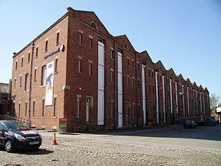
The 1830 warehouse, Liverpool Road, Manchester, is a 19th-century warehouse that forms part of the Liverpool Road railway station complex. It was built in five months between April and September 1830, "almost certainly [to the designs of] the Liverpool architect Thomas Haigh". The heritage listing report attributes the work to George Stephenson and his son, Robert. It has been listed Grade I on the National Heritage List for England since May 1973.

The Rustavi church of the Assumption of Mary better known as Rustavi Sioni is a Georgian Orthodox church in Rustavi, Georgia. It was built in 2000-2011. The project was created by Besarion Menabde, Nikoloz Abashidze and Nikolos Dadiani. The building works were led by Temur Burkiashvili.
Milacemide (INN) is an MAO-B inhibitor and glycine prodrug. It has been studied for its effects on human memory and as a potential treatment for the symptoms of Alzheimer's disease. Early clinical trials did not show positive results however, and the drug is now abandoned.
Iowa Township is a township in Washington County, Iowa, USA.
Hrabové is an urban area of Bytča. It lies in the north-west of Slovakia, in the Bytča District of the Žilina region.
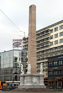
The Liberty Memorial, located in front of Central Station in Copenhagen, Denmark, is a 20 meter tall obelisque erected in memory of the peasant reforms in 1788 which led to the abolition of adscription.
Coal Township is a township in Vernon County, in the U.S. state of Missouri.


